


Our Main Office
Construction Equipment Guide
470 Maryland Drive
Fort Washington, PA 19034
800-523-2200
Tue October 17, 2006 - Midwest Edition
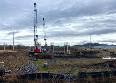
Bids for Phase 2A of the $350-million U.S. 395 Carson City Freeway project are expected to be let by December 2006, according to Jim Gallagos, project manger of the Nevada Department of Transportation (NDOT).
The Carson City Freeway is located just east of Carson City “and involves a nine-mile-limited-access freeway that begins at the north end of U.S. 395 and will end at the U.S. 395/U.S. 50/Spooner Summit Interchange,” explained NDOT Public Information Officer Scott Magruder.
Included in the project’s scope of work are the construction of 9 mi. (14.5 km) of limited access freeway, bridges, overpasses, underpasses, a drainage system, cultural resource investigations, aesthetics, landscaping, re-vegetation of earthen freeway “slopes,” use of landscape boulders, slope contouring, arrowhead landscaping, construction of bicycle paths and pedestrian sidewalks, and the construction of sound walls.
The cultural resource investigations incorporated into the project called for NDOT archaeologists to relocate a very large prehistoric site known since the 1930s because it was partially located within the newly planned right-of-way for U.S. 395.
As part of the environmental clearance program conducted for the project, the Federal Highway Administration (FHWA), working with NDOT, retained the services of the Louis Berger Group Inc. to conduct a series of archaeological investigations at this large prehistoric site.
“The final appearance of the Freeway corridor is important to the success of the project. It not only must be functional from a traffic standpoint, but the corridor must be visually acceptable to the community. Therefore, as part of the planning and design for this project, consideration has been and will continue to be given to the aesthetics of various features throughout the Freeway corridor,” Magruder said.
With regard to landscaping, Magruder pointed out that NDOT has had an ongoing partnership with Carson City and the advocacy group known as Gardeners Reclaiming Our Waysides (GROW).
The NDOT/GROW partnership focuses on what is mutually acceptable for freeway landscaping and how to address the funding source for this element of the project.
Through this collaborative partnership, a plan has been developed to provide for basic landscaping treatment as the freeway is built. The plan also allows for future enhancements and additional landscaping features.
Components of the landscaping plan will include re-vegetation of earthen landscape “slopes,” Magruder said.
The re-vegetation includes seed mixes consisting of native plant species common to freeway surroundings; application of top soil in the most visible areas to enhance vegetative growth; and additional protection of sprayed on seeding mix during the plant establishment period in the more wind prone areas. These seed mixes are for the Carson City Freeway side slopes.
In addition, landscape boulders will be placed on highly visible freeway slopes with 125 boulders donated by Carson City for use on the project. Additional boulders excavated during construction of the Freeway also will be used for landscaping.
Plans also call for the large traffic island areas at freeway interchanges to be contoured and seeded to enhance their appearance and for the large cut slope needed at the north end of the project on Lakeview Hill to be contoured and benched to better blend in with the surrounding terrain.
Magruder also said that power drops will be placed at gateway locations for use in future landscaping efforts and irrigation sleeves also will be placed at gateways and along a multi-use path for use in future irrigation installations associated with landscaping efforts.
Furthermore, he pointed out that NDOT and Carson City are working together to perpetuate and enhance the non-motorized roadway system in the Freeway area.
“New multi-use paths along the freeway will connect to existing facilities, such as bicycle lanes, paths, designated routes, or sidewalks. All new facilities will be compatible with the Carson City Bicycle System Plan. Existing bicycle lanes, paths or routes, where they cross the freeway, will be perpetuated with the proposed improvements. Sidewalks will be provided to accommodate pedestrian movement.”
While Phase 2A will be bid by December 2006, it should be noted that Phase 2A is the third phase of this four-phase project that began in 1999, Gallagos said.
Phase 1A began in 1999 and was completed in 2001. This $15-million phase was awarded to Frettner Construction Co. and called for the construction of four 100-ft.- (30 m) long, two-lane concrete box girder bridges, 1 mi. of box culverts and channels and drainage. The bridges are at Arrowhead Drive, Northgate Lane, Emerson Road and College Parkway.
A half interchange was built at Arrowhead Drive with a northbound off-ramp from the freeway and a southbound freeway on-ramp to the freeway being provided. A connection between Bonanza Road and Arrowhead Drive was built on the east side of the freeway. It is known as the Imus Connector.
Arrowhead Drive also was realigned on the west side of the freeway to allow for an improved intersection with Carson Street. The intersection aligns with Eagle Valley Children’s Home Road and the access road to the future Carson-Tahoe Hospital on the west side of Carson Street.
Additionally, the Arrowhead interchange incorporates the use of traffic roundabouts into the design. Roundabouts were constructed at the intersections of the Arrowhead Drive/Northbound freeway off-ramp/Imus Connector and the Arrowhead/Southbound freeway on-ramp.
Phase 1A included conveyance facilities from Northgate Lane to just south of College Parkway, drainage facilities needed for the realignment of Arrowhead Drive, and a temporary water quality treatment facility to collect sediment produced from Phase 1A construction activities.
The conveyance facilities in this area were constructed with the bridge construction at Arrowhead Drive, Northgate Lane, Emerson Road and College Parkway to avoid disturbance near the bridge foundations at a later date.
During the construction of Phase 1A, the remainders of the drainage facilities were completed and the temporary water quality basins were replaced by a permanent facility within the Lampa Ranch area.
“The drainage system is the result of cooperative planning between NDOT, Carson City, the U.S. Army Corps of Engineers, the U.S. Fish and Wildlife Services, the Nevada Division of Wildlife, and many other agencies,” said Magruder.
“The resulting system will not only provide for the drainage associated with the Carson City Freeway to provide adequate protection of the freeway improvements, but it will also provide substantial flood control benefits for Carson City and a substantial reduction in the limits of flooding as depicted on Federal Emergency Management Agency [FEMA] Flood Insurance Rate Maps as well as a reduction in peak flows and water quality improvements throughout the entire drainage system, and reduce the cost of drainage facility construction now and in the future.”
Phase IB is a $69-million, 4.8-mi. (7.7 km), four-lane stretch of freeway located on the north side of Carson City from U.S. 395 north to U.S. 50 East. The general contractor for Phase 1B was AMES Construction of Salt Lake City.
Gallagos said Phase 1B began in 2003, two years after the completion of Phase 1A because of a lack of funding. It was completed in Spring 2006.
Included in Phase 1B are three additional sets of bridges similar to the bridges constructed during Phase 1A.
Magruder said the completion of Phase 1B has helped to ease traffic congestion on the existing U.S. 395, which is used by more than 40,000 vehicles each day.
Phase 1B also includes major drainage system improvements for flood control, sound walls and a multi-use path for bicyclists and pedestrians,” Magruder added, noting that “federal, state and Carson City gas taxes” helped fund this phase of the project.
Phase 2A, estimated at $60 million, will be let for bids by December 2006. Gallagos said bids for this phase of the project are expected to be opened by March 2007 with construction expected to start by April 2007 and completed by December 2008.
Magruder said Phase 2A will complete the freeway from U.S. 50 East to Fairview Drive.
Phase 2A calls for the construction of the central portion of the Carson City Freeway starting at the U.S. 50 East Single Point Urban Interchange (SPUI), which is the southern terminus of the Phase 1 project, and continue south on a new alignment to a partial interchange at Fairview Drive.
Plans also call for the southern ramps for the U.S. 50 East SPUI to be constructed to provide a full interchange, a partial interchange at Fairview Drive to provide full access to and from the freeway north of Fairview Drive; a grade separation structure at East Fifth Street to allow traffic to pass over the Freeway with no access provide to the Freeway; and the Linear Ditch Park multi-use bicycle and pedestrian path will be realigned to cross the Freeway north of the East Fifth Street grade separation, connecting to the Carson City bicycle path at Butti Way.
Phase 2A plans also include a drainage system to convey roadway drainage and flood flows intercepted by the Freeway alignment to the Kings Canyon Drainage Channel (Lampa Ranch Area constructed in Phase 1) drainage.
Magruder said the drainage system will include detention basins, channels, box culverts and pipes within the Freeway corridor conveying storm runoff flows to water quality basins to provide water quality treatment of the storm water discharges from the freeway and the surrounding drainages before it reaches the Carson River.
Phase 2A will incorporate the South Water Quality Basin, located on the east side of the Freeway, south of Fifth Street. On the west side of the Freeway will be the H Tributary Channel, an 80-ft. (24.4 m) wide trapezoidal channel which extends north of Linear Ditch and conveys flows to the Kings Canyon Drainage Channel.
NDOT has conducted a noise study along the Phase 2 Corridor to determine where noise mitigation measures will be required. No sound walls are planned for Phase 2A of the project.
Phase 2A also will include a 12-ft. (3.6 m) wide multi-use path on the south side of U.S. 50 East from the western project limit at Humboldt Lane to the Pinon Plaza driveway, where it converts to a sidewalk. A similar path was constructed on the north side of the roadway in Phase 1B.
In addition, bicycle lanes and sidewalks will be constructed along Fifth Street, Fairview Drive, Koontz Lane, Clearview Drive and Snyder Avenue. Sidewalks and shoulders will be included with the South Carson Street interchange improvements included in the project.
The Linear Ditch Park multi-use bicycle and pedestrian path will be extended to the freeway as part of Phase 2A. Plans call for the path to travel north parallel to the freeway on the west side, pass under Fifth Street, cross under the Fifth Street grade separation and continue along the top of the drainage channel to connect to Carson City’s multi-use trail system at Butti way. This multi-use path also will connect to the city’s path that will be extended along Fifth Street.
Phase 2B, the fourth and final phase of the project, will complete the project from Fairview Drive to U.S. 50/Spooner Summit Interchange. Bids for this phase will be let during the winter of 2007.
Bids, Gallagos said, will be opened by Spring 2008. Construction of this phase is expected to be completed by the end of 2010.
Estimated by Gallagos at approximately $120 million, Phase 2B will consist of approximately three additional miles of four new lanes of freeway, four concrete over-and underpasses, and a new alignment that will connect to U.S. 50 West at the existing U.S. 50 West-Tahoe Junction/South Carson Street intersection.
Magruder said that while the freeway will be designed for two lanes in each direction, provisions will provide for future widening in the median.
Phase 2B also will call for the construction of the southern ramps for the Fairview Drive Interchange, a full SPUI at the U.S. 50 West-Tahoe Junction/South Carson Street Intersection; grade separation structures at Koontz Lane, Clearview Drive and Snyder Avenue; a drainage system to convey roadway drainage and flood flows intercepted by the Freeway alignment to the King Canyon Drainage Channel, and sound walls.
Phase 2B’s drainage system will consist of three detention basins, each of which also serves as water quality basins; the Bennett Detention Basin, at the intersection of Bennett Avenue and Hillview Drive, the Ponderosa Detention Basin to be located on the north side of the Freeway between Center Drive and Ponderosa Drive; and the Voltaire Detention Basin that will be located in the northeast corner of the South Carson Street Interchange.
In addition, the Edmonds Channel will run 2.1 mi. (3.4 km) along the east side of the Freeway from south of Clearview Drive to Linear Ditch. Just south of Linear Ditch the channel will cross the west side of the Freeway using a reinforced concrete box culvert, which will serve as a combination drainage conveyance and livestock undercrossing.
Magruder also said that the size, depth and visibility of the Voltaire Detention Basin will be specifically designed for aesthetics. These aesthetics will include “curved boundaries, contoured slopes, and native vegetation,” he added.
Continuing, Magruder said, the sound walls in Phase 2B will be constructed along the Freeway Corridor to minimize the impact of traffic noise to residences adjacent to the Freeway.
These sound walls will be similar to those already constructed. They will range from 6 to 18 ft. (1.8 to 5.5 m) in height and reduce noise levels by five decibels to as much as eight decibels.
He also said that 4.5 mi. (7.7 km) of sound walls were completed during the first phase and that three additional miles of sound walls will be constructed in Phase 2B.
Gallagos said project challenges in Phase 1 included “alignment of the northern part of the Freeway within flood plain and floodway. This meant that during construction, water had to be conveyed around the work area.
“The solution was continuous pumping of the water, construction of diversion ditches, and construction of temporary storm drain system blockages,” Gallagos added.
Aesthetics on the sound walls also were a challenge, according to Gallagos.
“The four miles of cast-in-place concrete, 12-foot to 18-foot high sound walls had to be constructed over the bridges while maintaining a continuous pattern stipulated by the landscape architect. The solution was to use reusable form liners that could be custom fitted in transition areas around bridge structures,” he explained.
Gallagos also said that the reconstruction of Carson City’s main sewer line was challenging because “the low point of the valley crosses the Freeway at a flat grade. This meant the sewer system had to be reconstructed within tolerances that provided challenges to the project team.
“Utilities were also challenging because it is done in each phase and it is done concurrent with the new construction in order to expedite the schedule.
“The solution to this challenge was to use a phased schedule for the first two phase of the project, while fast-tracking the project to allow work to be performed concurrently,” Gallagos said.
Magruder added that NDOT and AMES Construction Co. met weekly to discuss ongoing and upcoming construction activities and that NDOT established a project Web site to help keep the pubic informed.
In fact, community outreach plays a major role in the project. For example, in February, when Phase 1B was nearly complete, NDOT invited the public to a 10 kilometer run and a five-kilometer “fun run” or to walk or ride a bicycle on the new, soon-to-be opened part of the Carson City Freeway.
The actual opening of the Carson City Freeway to traffic occurred following a ribbon-cutting ceremony on the Freeway grade near the North Carson Street bridge structure. Nevada Governor Kenny C. Guinn addressed attendees and officially opened the Freeway to traffic.
Magruder noted that the $350-million estimate for all four phases of the project is for both the design and the construction of the project. CEG
Construction Equipment Guide
470 Maryland Drive
Fort Washington, PA 19034
800-523-2200
Construction Equipment Guide covers the nation with its four regional newspapers, offering construction and industry news and information along with new and used construction equipment for sale from dealers in your area. Now we extend those services and information to the internet. Making it as easy as possible to find the news and equipment that you need and want.
Contents Copyrighted 2024, by Construction Equipment Guide, which is a Registered Trademark, registered in the U.S. Patent Office. Registration number 0957323. All rights reserved, nothing may be reprinted or reproduced (including framing) in whole or part without written permission from the publisher. All editorial material, photographs, drawings, letters, and other material will be treated as unconditionally assigned for publication and copyright purposes and are subject to Construction Equipment Guide’s unrestricted right to edit and comment editorially. Contributor articles do not necessarily reflect the policy or opinions of this publication.
Read our privacy policy here.
Mastodon