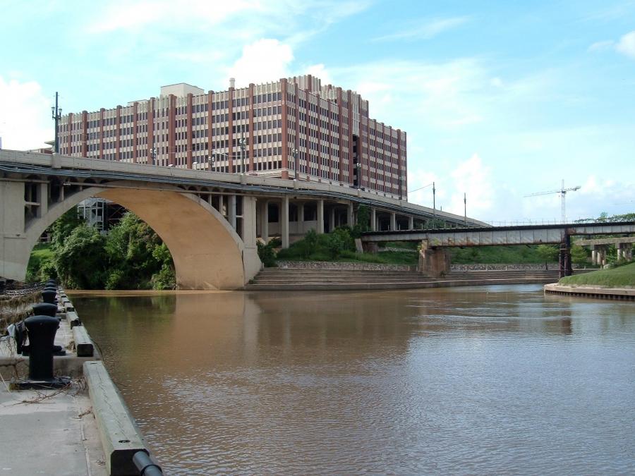
Lined by concrete surfaces to better channel floodwaters, the bayou northwest of downtown draws walkers and bikers to its walkways, but much of the corridor is hardly a scenic gathering place.
HOUSTON (AP) When Bob Lee looks out at the White Oak Bayou, he sees a waterway that could be so much more.
Lined by concrete surfaces to better channel floodwaters, the bayou northwest of downtown draws walkers and bikers to its walkways, but much of the corridor is hardly a scenic gathering place. In contrast, Houstonians flock to nearby Buffalo Bayou Park, where the waterway flows through a natural landscape of trees, plants and grasses.
“It would be so nice to be walking along something that was more like Buffalo Bayou,” said Lee, a resident of Houston's Heights neighborhood for more than 30 years who sits on the White Oak Bayou Association board.
The Houston Chronicle reports that now, aging infrastructure and costly repairs are prompting the Harris County Flood Control District and a local redevelopment authority to take a second look at the White Oak Bayou's design.
They are assessing whether portions of the concrete lining can be replaced or retooled while boosting the bayou's ability to handle floodwaters.
Although the study is just getting underway and improvements could be years away if they occur at all, the study holds the promise of more trails, natural features and meandering channels for the bayou corridor, which in turn could spur economic development.
The effort in part reflects the idea that waterways where flooding must be controlled don't have to be eyesores and in fact can become more natural settings for residents to bike, walk and gather. It follows decades-old conversations about how to shape waterways in a flood-prone region like Houston, where the rapidly growing population has increasingly come to demand improvements in quality of life.
“Pretty is never going to trump functional,” said Ann Lents, chairwoman of the Memorial-Heights Redevelopment Authority, which has partnered with the flood control district on the channel restoration study.
She added: “But because of new techniques, if we can find a way to do both better, I think that will be a great thing.”
Efforts to do more with the waterways that gave Houston one of its nicknames — the Bayou City — are not new.
In the 1960s, some residents, including local conservationist Terry Hershey, saved Buffalo Bayou from a massive plan to straighten, strip and line the waterway with concrete, a fight that was joined by then-Congressman George H.W. Bush.
In the early 1990s, neighborhood advocates led an effort to prevent lining parts of the Sims Bayou with concrete, instead using a special type of structure that looks like a honeycomb and allows plants to grow through and on top, said Evelyn Merz, a co-founder of the Sims Bayou Coalition.
That project was finished in recent years, Merz said, and the bayou retains much of its natural feel.
“Who wants to walk alongside a concrete ditch?” she said. “If you're looking at it from an economic point of view, it's much more beautiful to have a green landscape than a gray one.”
Revisiting the Army Corps of Engineers' designs has caught on in other parts of the country, too. In Los Angeles, local officials are pushing an ambitious $1 billion restoration of the Los Angeles River.
Steve Hupp, water quality director for the Bayou Preservation Association, said the public recognizes such efforts.
“People enjoy voting with their feet basically,” Hupp said. “They like being in those locations because it has more texture, it has more diversity to it.”
But Merz stressed that it can be costly to prevent flooding on a long-term basis and spruce up an area at the same time.
The concrete lining is known to be effective at channeling floodwaters. A pricey project to rip that out and put something else in can be a hard sell.
“It is much more efficient,” Merz said of the concrete. “You can basically move the water out faster, but it's also an old way of thinking.”
Harris County commissioners last month approved the agreement between the flood control district and the Memorial-Heights Redevelopment Authority to conduct the study on parts of the White Oak Bayou.
The authority uses money generated by a local tax-increment reinvestment zone to fund infrastructure improvements, reimburse developers and upgrade parks and public spaces. The zone in this case runs along portions of the bayou from the 610 Loop in the northwest down to around Houston Street, as well as some areas around Memorial Boulevard near Studemont Boulevard and Dunlavy Road.
Any potential project would have to be in the boundaries of the zone, though it has yet to be decided which portions, if any, of White Oak Bayou would be targeted.
The study will look at options for “flood risk management, water quality, environmental concerns, adjacent area redevelopment and regional recreation impact,” according to the agreement.
The authority will pay up to $275,000 for the study. It has yet to be determined who would pay for any actual restoration work, though Matthew Zeve, chief operating officer of the flood control district, said Harris County taxpayer funds would not be used.
Zeve said a draft “scope” of the work that can be done — essentially a broad overview of what to study — has been completed and is being reviewed by the Houston public works department and redevelopment authority officials.
The next step, Zeve said, would be to hire a consultant who could determine how to carry out the engineering plan and provide a cost estimate. Then the district, the authority and others could determine whether to go forward.
For the flood control district, the main focus is seeing how a potential project would affect the White Oak's ability to carry floodwaters through, Zeve said. If a proposal would make flooding along the bayou worse, it would come off the table.
The district is looking at whether a project might be cheaper than paying hundreds of thousands of dollars every year for upkeep.
“Whatever goes in there, how much money in annual maintenance will it save?” Zeve said.
The district spends roughly $1 million per year on maintenance on the White Oak Bayou from where it joins Buffalo Bayou up north to Cole Creek, and officials say most of the costs are for engineering and construction. These expenses would be eliminated by removing the channel's concrete lining, but this would increase “vegetation management and erosion repair” costs, Zeve said.
Zeve said any project spawned by the study would be separate from work currently being performed on the bayou, such as the hike-and-bike trail extension that's part of a public-private project to build parks and trails along Houston's waterways, known as the Bayou Greenways 2020 initiative.
Lee, who also sits on the Bayou Preservation Association Board, knows the study is an incremental step, one that may or may not bring change to the bayou.
Even with the study completed, it could take years to fund and complete the work.
“I think it's going to be one of those things where you're going to have to realistically see, what can we do?” Lee said. “The flood issues are paramount. Money is going to be difficult to find.”
Still, he's encouraged that someday he might be able to see White Oak Bayou shed its concrete.
For more information, visit http://www.houstonchronicle.com.
Today's top stories


