


Our Main Office
Construction Equipment Guide
470 Maryland Drive
Fort Washington, PA 19034
800-523-2200
Mon July 13, 2009 - Midwest Edition
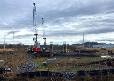
Travelers along U.S. Route 460 through the rugged mountains of Pike County, Ky., will follow a new and improved route when the four-lane highway from Pikeville through Elkhorn City joins up with a planned highway in the mountains of southwestern Virginia.
According to Sam Hale, TEBM PD&P B1, District 12, commuters are eager to start using new sections of the roadway. Initially concerned that the proposed road was going to take their property, Hale said now everyone is anxious to start driving on it. Public meetings and extensive public involvement in the planning/design phase of the project helped soothe concerns. In addition, local residents are familiar with the process, having been through construction on U.S. Route 23 and U.S. Route 119, also Appalachian Project Development roads, and know what to expect. “Local response to the new roadway is positive.”
Coming Around the Mountain
U.S. Route 460 is a spur of U.S. Route 60, beginning where U.S. 60 east turns right a few miles east of downtown Frankfort, Ky., and extending 655 mi. (1,054 km) to Norfolk, Va. Along the way, the sometimes twisty two-lane road passes through Virginia, West Virginia and Kentucky and is considered the primary east-west highway in the northern part of southwest Virginia.
U.S. Route 460 once ended in St. Louis. Between there and Frankfort, it was a major highway during the pre-interstate era. In more recent years, Interstate 64 has superseded U.S. Route 460 as a more direct route, leaving old U.S. Route 460 to become parts of Illinois Routes 15, 142 and 14, as well as State Roads 66 and 62.
The reconstruction project will provide an alternate route for U.S. Route 460 traffic from U.S. Route 23 near Yeager, Ky., to the Breaks Interstate Park near Breaks, Va. The new four-lane, partially controlled access highway will increase travel speeds, decrease travel time and provide a safer route within this corridor.
Interchanges have been proposed at U.S. Route 23, Greasy Creek Road, Kentucky, state Route 195 at Marrowbone and at Kentucky state Route 80 near Elkhorn City. The reconstruction being developed by the Kentucky Transportation Cabinet will tie in at Virginia state Route 80 in Buchanan County, Va. The Virginia Department of Transportation is in the process of developing plans to connect this segment of U.S. Route 460 to the proposed Coalfields Expressway approximately 5 mi. (8 km) into Virginia.
The section from Interstate 81 at Christiansburg, Va., to U.S. Highway 23 in Pikeville, Ky., is Corridor Q in the Appalachian Development Highway System. That was initiated after a 1964 President’s Appalachian Regional Commission report to Congress stating that economic growth in the area was not possible while the region remained isolated. The high cost of building highways through the Appalachian Mountains was prohibitive, leaving residents to rely on a network of narrow, winding two-lane roads that made travel through the mountainous terrain slow and unsafe.
The PARC report and the Appalachian governors made a modern highway system a priority, considering it a key to economic development. Congress subsequently authorized the construction of the Appalachian Development Highway System (ADHS).
The Appalachian Development Act of 1965 was designed to generate economic development in previously isolated areas, supplement the interstate highway system that served cross-country traffic more than local residents and provide access to areas within the regions. Currently, the ADHS is authorized at 3,090 mi. (4,973 km), including 65 mi. (105 km) added in 2004 by public law. By the end of Fiscal Year 2004, approximately 85 percent – 2,627 mi. (4,227 km) – were complete or under construction. Many of the remaining miles are among the most expensive and difficult to build.
Costly Work
According to an Associated Press report, Sara George, spokeswoman for the Kentucky Transportation Cabinet, agrees, stating that this could be one of the costliest road construction projects in Kentucky’s history.
The Transportation Cabinet is an executive branch agency responsible for overseeing the development and maintenance of a safe, efficient, multi-modal transportation system throughout the commonwealth. It manages more than 27,000 mi. (43,452 km) of highways, including 3,600 mi. (5,793 km) of primary roads, 20,500 mi. (32,991 km) of secondary roads and 1,400 interstate and parkway mi. (2,253 km). The agency also provides direction for 230 licensed airports and heliports and oversees all motor vehicle and driver’s licensure in the commonwealth.
Kentucky received $421 million in stimulus funding for transportation projects, of which $368 million was set aside for statewide highway improvements.
Approximately $148 million of the stimulus must be obligated to eligible projects on or before July 1, 2009. However, no stimulus money is being used on this project.
Eighty percent of the funding comes from the Appalachian Regional Commission, with 20 percent matching state funds. The Appalachian Regional Commission was established by Congress in 1965 and encompasses 13 Appalachian states. One of the commission’s four goals is to “Build the Appalachian Development Highway System to reduce Appalachia’s isolation.” The U.S. Route 460 project, along with other corridor routes such as U.S. Route 119 and U.S. Route 23 in Eastern Kentucky, are part of this highway system. The portion improved under this system remains unfinished between Grundy, Va., and Pikesville.
Long-Term Schedule
Work on the $600 million project is underway, scheduled for completion in six years. Hale said the first section of new U.S. Route 460 was awarded in 2002. Work began in 2003 and construction of the last sections is expected to be completed in 2016. Work is currently on schedule for all but a couple of sections due to right-of-way acquisition problems, but Hale doesn’t anticipate a delay with the overall expected completion date, especially with contractors working two shifts most days.
There are four main general contractors working different sections of the roadway. Hale explains that each is given a certain amount of time to complete their project based on the “working day” method. “The working day concept is where a work day is Monday thru Friday, excluding holidays, and where the weather does not prevent the contractor from working at least five hours per day.”
The total roadway corridor is divided into sections that can be completed as a unit without impacting the adjacent section. Despite this concept aimed at isolation, there have been instances when the contractors have to coordinate activities to keep the project moving. Nevertheless, overall, things are running smoothly. Hale explains that, “The Transportation Cabinet has the job of overseeing coordination and inspection of the project and meetings are held when there is an issue concerning adjacent projects. The sections have been well designed and the construction contracts let out at a schedule where there have not been any major issues between contractors.” The principle design firms are Palmer Engineering of Winchester, Ky., and QK4 of Louisville, Ky.
The project replaces 25.3 mi. (40.7 km) of two-lane roadway from just south of Pikeville to the Virginia State line. Most of this existing U.S. 460 was constructed in the 1930s and ’40s with some spot improvements in the ’60s. Traffic counts vary from 12,000 ADT in the Pikeville area to 3,000 next to the Virginia line. The project takes a new route south of existing U.S. 460, but parallels the old route almost all the way to the state line. “It deviates from the existing route just west of Elkhorn City and then takes a more direct route to Virginia just north of Elkhorn City,” Hale said.
The alignment replaces a winding two-lane roadway with steep grades and numerous sharp curves that had little or no shoulders. In addition, this alignment is better because it reduces the right-of-way impacts to the houses built along existing U.S. 460, while allowing numerous access points to local roadways along the corridor.
The new roadway is a four-lane roadway with depressed median and wide shoulders and is built on a 60-mile-per-hour design speed. Hale believes it will be a safer and more easily maintained highway. “Although not built to interstate or parkway standards with fully controlled access, it is only one step below having partially controlled access with many of the same safety features.”
Right of Work
Three more construction projects on U.S. 460 in Pike County are scheduled to be let in 2009 by the Transportation Cabinet. Right-of-way acquisitions and utility relocation efforts have been ongoing for several years. Hale estimates the right-of-way is 95 percent clear. “We have let eight construction projects to date and have five remaining,” he elaborates. The remaining sections are in the right-of-way acquisition and utility relocation phases and construction lettings will be scheduled as funding is received. “Because of the method of building the roadway in sections, we will be letting the surfacing contracts separately where completed sections can be used by the public. This will be between the five major intersections planned for the corridor.”
According to the Appalachian News-Express, Section 7A at the east end of the corridor, which includes an interchange with Kentucky state Route 80, will be the next section let to bid. It will run in the hillside north of Beaver Creek, eventually crossing the creek at Stonecoal Fork. Section 8 connecting the Right Fork of Beaver Creek to the Virginia State Line will be let late in 2009. An interchange connecting the new U.S. 460 to U.S. 23 also will be let around the same time. “With these lettings,” the paper reports, “approximately 65 percent of the U.S. 460 corridor will be under construction.”
The Appalachian News-Express also reports Sara George commenting that portions of the highway along the Kentucky mountaintops will offer spectacular views of central Appalachia and provide a much safer route than the narrow, winding road it replaces. Beyond merely enhancing the view for drivers, Hale said the route was selected to lessen the impact on existing houses and to limit the impact on the environment. “The route, which is higher on the ridges than the existing roadway, limits impact on streams and rivers below,” she stated. “This is done by the use of bridges and fills at the tops of the hollows where they will not affect the larger streams.” The head-of-the-hollow fills also have a secondary purpose: to create flat developable area where industry can locate. Upon completion of the project, Hale said they expect to have an additional 200 acres (80.9 ha) that can be developed.
Challenging Climb
The new four-lane roadway stretches 16 mi. (25.7 km), for 64 lane mi. (102.9 km).
“When completed, we will have moved approximately 100 million cubic yards of earth and rock,” Hale calculated. “There will be 21 bridges ranging from four-lane overpasses to twin two-lane structures, one of which will be 320 feet high from roadway to the ravine below. Another bridge will be a twin structure, each of which will be approximately 2,400 feet long with spans up to 500 feet long.”
One of the bridges, known as the John Moore Branch Bridge, was constructed to accommodate the weight of loaded 777 rock trucks. Hale said crews will haul approximately 9 million cu. yds. (6,880,994 cu m) of material across this bridge and when completed the bridge will then provide access to 120 acres (48.6 ha) of newly created developable property.
The new roadway will provide better access to the Breaks Interstate Park which boasts of the deepest gorge east of the Mississippi River. The park next to Elkhorn City is a destination for white water rafters and kayakers to experience rafting down the Russell Fork of the Big Sandy River.
With continued ADHS funds, this entire U.S. 460 corridor should be completed within 5-10 years, barring any unforeseen challenges. To date, Hale said the only major item crews have had to deal with is the location of abandoned coal mines in the cuts. “These mines require stabilization in the areas of our major cuts. This is done by filling the mine opening with [a] combination of stone and grout to carry the weight of the rock above and keeping rock cut above them from collapsing. We first used this method when working on another Appalachian Highway Project, U.S. 19, and it seems to be working adequately.”
Not anticipating any further delays, Hale expects the project to be completed on time and within budget. CEG
Construction Equipment Guide
470 Maryland Drive
Fort Washington, PA 19034
800-523-2200
Construction Equipment Guide covers the nation with its four regional newspapers, offering construction and industry news and information along with new and used construction equipment for sale from dealers in your area. Now we extend those services and information to the internet. Making it as easy as possible to find the news and equipment that you need and want.
Contents Copyrighted 2024, by Construction Equipment Guide, which is a Registered Trademark, registered in the U.S. Patent Office. Registration number 0957323. All rights reserved, nothing may be reprinted or reproduced (including framing) in whole or part without written permission from the publisher. All editorial material, photographs, drawings, letters, and other material will be treated as unconditionally assigned for publication and copyright purposes and are subject to Construction Equipment Guide’s unrestricted right to edit and comment editorially. Contributor articles do not necessarily reflect the policy or opinions of this publication.
Read our privacy policy here.
Mastodon