


Our Main Office
Construction Equipment Guide
470 Maryland Drive
Fort Washington, PA 19034
800-523-2200
Mon March 20, 2017 - West Edition #6


A major undertaking that will improve both user safety and access to popular recreational destinations in Nevada is taking shape, as construction continues on the SR 28 Shared Use Path Project. The Nevada Department of Transportation (NDOT) is overseeing the work, which also will help protect and preserve Lake Tahoe's water quality.
"This has been in the planning and environmental phases for well over a decade," said NDOT senior project manager Nicholas Johnson. "Within the past year, the environmental process has finished, and the funding identified for construction, making it an opportune time to finalize design and begin construction."
The effort is part of an overall strategy to connect a shared use path from Nevada, state line to state line.
"This is one of the first steps in implementing the greater master plan along the SR 28 corridor. The project will serve the local community in Tahoe, motorists, recreationalists, bicyclists, tourists and anyone visiting, traveling or using the recreational elements of Lake Tahoe."
SR 28 south of Lakeshore Drive, in Incline Village on Lake Tahoe's east shore, runs alongside almost a dozen miles of undeveloped shoreline. The two-lane road is the only access route for more than one million recreationalists, and more than two million vehicles each year. The conditions along the SR 28 corridor are less than ideal for drivers and the roughly 2,000 pedestrians and bicyclists who share the existing travel lanes and narrow shoulders during peak times.
Limited parking and lack of safe, non-motorized access to popular destinations within the corridor result in large numbers of motorists parking along narrow, mostly unpaved shoulders on the up- and downhill sides of the roadway, creating additional roadside safety hazards, as well as erosion issues.
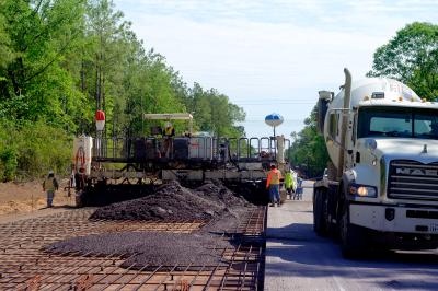
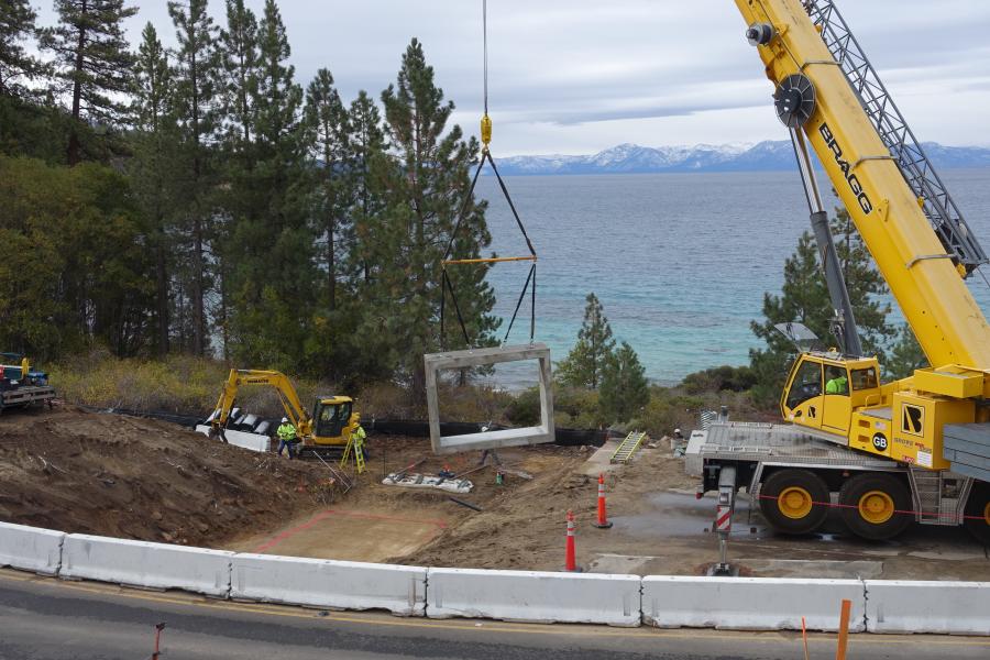
The project is funded by federal, state, local and private funding sources. Work includes a 10-ft. (3.33 m)-wide, paved shared use path from the south end of Incline Village to Sand Harbor; relocation of shoulder-parking to new parking lot facilities near Ponderosa Ranch and Tunnel Creek Café; and a SR 28 pedestrian/bicycle undercrossing near Tunnel Creek. SR 28 safety improvements include center line rumble strips and emergency/maintenance turnouts, along with erosion control and water quality enhancements.
NDOT has contracted Granite Construction to implement the State Route 28 Shared Use Path and Safety/Stormwater Enhancement by fall of 2018. NDOT is using the construction manager at risk process, effective in environments such as Lake Tahoe, where contributing factors make construction more difficult.
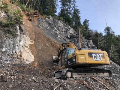
"There is challenging terrain," said Johnson. "Approximately two miles of the shared used path will be constructed between State Route 28 and the shoreline of Lake Tahoe. The area is undisturbed, natural terrain, with slopes exceeding 1:1 and full boulders and trees, making it very difficult to stage equipment for construction of the project. There are minimal locations where the contractor can access the site from SR 28 to get equipment in and onto the alignment of the path for construction."
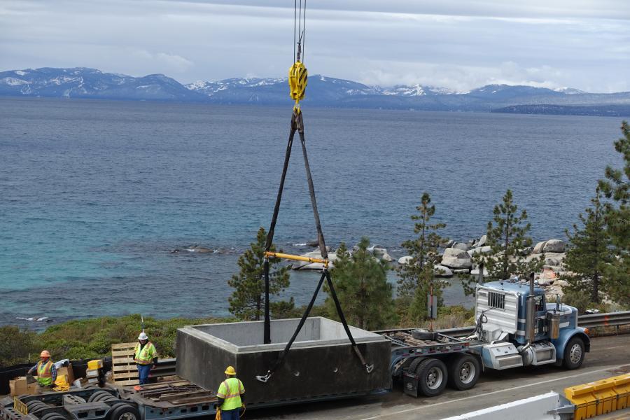
There are six proposed bridges along the shoreline of Lake Tahoe, and more than 1,000 ft. (304.8 m) of soil nail retaining walls. There are considerable obstacles getting drilling equipment into the areas to construct the pile foundations, as well removing the excavated materials for the soil nail walls.
In addition, Lake Tahoe is one the most environmentally protected areas in the United States. All work must be performed in a way as to not allow construction debris or pollutants into the lake. Crews are committed to creating the smallest construction footprint possible, to preserve the natural terrain.
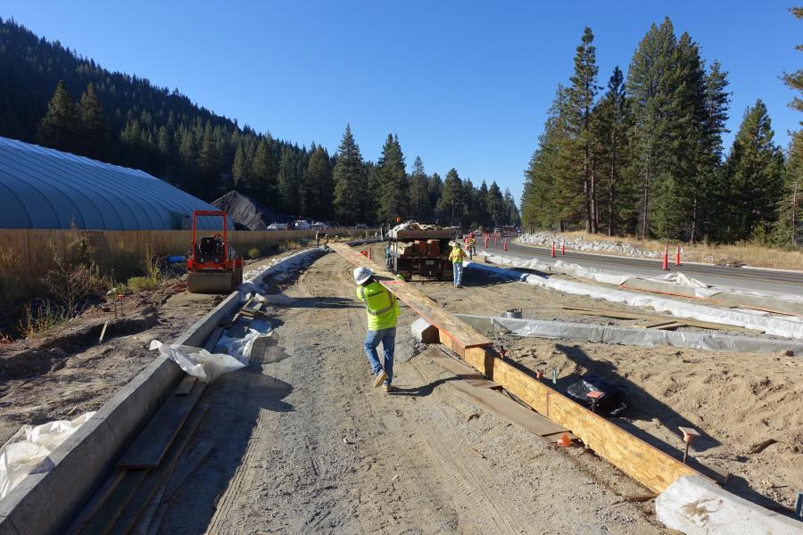
Phase I of the project began in August 2016, and was completed approximately two months later. The work included the relocation of major utilities within State Route 28; construction of the shared used path undercrossing; and the path parking areas. Johnson said to date, weather has not been a concern.
"But it's always a factor when working within the Tahoe basin and high elevations in the Sierra mountain range. Typically, work can only be performed between the months of May through August, and work is shut down during the winter months. Anytime a storm approaches, the contractor must have all best management practices in place before they stop work, so that soils, pollutants and debris from the construction site do not wash out into the lake."
Phase II of the project includes construction of the more than 3 mi. (4.8 km) of shared used path; the new parking area; multiple bridge and retaining wall structures; drainage and water quality improvements; center line rumble strips; and ITS conduit within SR 28. Workers are ever mindful of the precarious nature of the job site.
"For a majority of the project, the site conditions are undisturbed in its natural condition, making it a challenge to access the project location in many areas with equipment. without destroying the many trees, vegetation and rock formations that line the shoreline," Johnson said.
Approximately 50,000 to 60,000 cu. yds. (38,228 to 45,873 cu m) of dirt will be moved on the project. Equipment being used includes cranes; an excavator; dump truck; drilling rigs for bridge foundations; soil nail walls; and pavers.
Steel and bridge components, dirt/onsite materials, concrete reinforcing steel, base and asphalt, drainage pipe, inlets, manholes, rock and rip rap are among the main materials needed to complete the work.
Johnson noted that construction of the bridges and walls along the path will be the most time-consuming part of the job. He also stressed the importance of an environmental assessment developed to evaluate alternatives to improve the safety, mobility and recreational use of the three-mile section of SR 28 between Sand Harbor State Park and Incline Village.
"The assessment is a decision document that meets the requirements of the National Environmental Policy Act, the Federal Highway Administration, the United States Forest Service and the Tahoe Regional Planning Agency. The document evaluates the selected alternative and their associated direct, indirect and cumulative impacts that could result from implementation of any of the alternatives described in the assessment."
Johnson said finding money for the ongoing work has been challenging.
"Utilizing as many available sources has been key to successfully implementing this project. One interesting element of the funding is the fact that more than 400 private donors donated approximately $1 million cumulatively toward construction. It is indicative of the nearly decade of community vision and dedication that have led us to construction."
As for how the SR 28 project will help protect and preserve Lake Tahoe's renowned water quality and clarity, said Johnson, "The water quality improvements that are proposed with this project will directly impact the recreational quality of the lake. NDOT, along with other jurisdictions around the lake, are working with the Nevada Division of Environmental Protection and the Lahontan Regional Water Quality Control Board to improve the clarity of Lake Tahoe through the reduction of storm water pollution. NDOT and others are focused on the current total maximum daily load target to reduce the amount of fine sediment entering Lake Tahoe."
According to Johnson, the implementation of the proposed slope stabilization, infiltration basins and roadside shoulder stabilization are among the ways NDOT is striving to achieve its environmental goals.
"These improvements also provide for improved safety, flood protection and ease of maintenance. Having a safe, clean roadway, as well as the benefit of the increased clarity of the lake, will have an inherent positive impact on recreational users and the overall community."
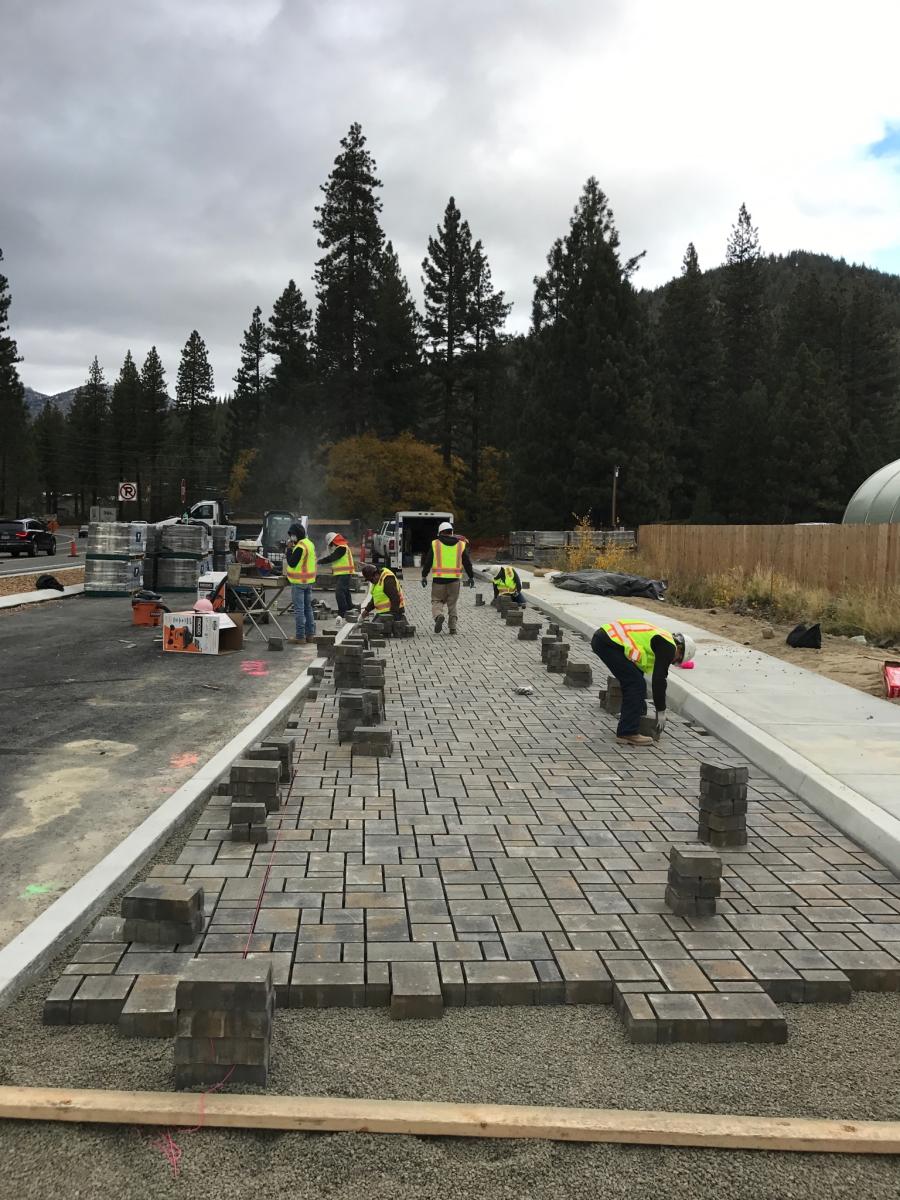
Shared use paths are designed for both transportation and recreation purposes, and are used by pedestrians, bicyclists, skaters, equestrians and others. A shared use path is typically a physically separated path from the roadway, paved, and is 10 to 14 ft. (3 to 4.3 m) wide. Shared use paths follow and meet the design requirements established by American Association of State Highway and Transportation Officials and the Federal Highway Administration, and also adhere to ADA requirements.
Regarding the relocation of shoulder-parking to new parking lot facilities near Ponderosa Ranch and Tunnel Creek Café, Johnson stated, "During the summer seasons at Lake Tahoe, shoulder areas of SR 28 get filled with cars parking, bicyclists and pedestrians walking up and down the roadway to reach their destination point. This creates a very narrow roadway for motorists to traverse, and a safety hazard for all using the roadway.
"The biggest safety improvement this project will bring is the elimination of shoulder parking along the three-mile stretch of SR 28 [Incline Village to Sand Harbor State Park], and relocating the parking to a designated area at the northern trail head. By constructing the path and parking areas, people wanting to park and access the shoreline now have a safe place to park off the roadway and reach their destination via the shared use path. The path will improve access for recreationalists, and by relocating the parking off the shoulders, will create a safer roadway for motorist and bicyclists to travel."
The new parking area will reportedly include more than 90 stalls and a transit stop. Additional parking areas will be needed for the remaining 8 mi. (12.8 km) of SR 28, south of Sand Harbor.
The work to install the undercrossing included relocating both Incline Village General Improvement District utility lines, excavating, placing the precast box members, backfilling the roadway and paving. All tasks were completed in six weeks.
The project safety improvements include the replacement and installation of new guardrail throughout the SR 28 corridor, construction of paved pull-out areas for emergencies and maintenance vehicles, installation of center line rumble strips from Incline Village to the junction of U.S. 50 and relocation of on-shoulder parking between Incline Village and the Sand Harbor State Park, to a new parking facility adjacent to the Ponderosa Ranch.
The water quality improvements include construction of soil filled rip rap slope protection at any location where construction may compromise the stability of the slope within the right-of-way or where existing high flows have been shown to erode the existing slope. Work also includes the extension of select existing culverts and addition of CMP "T" end sections, construction of rip rap lined "plunge pools", along with downstream rip rap protection with a length equal to two times the diameter of the culvert, and construction of curb and gutter along specific corridors to aid in the conveyance of flows to existing and proposed drop inlets.
The construction of storm drain systems also must be carried out, including drop inlets, manholes and reinforced concrete pipes, to convey flows to certain outlet locations to help alleviate current flooding conditions and erosion of slopes. Workers also must build infiltration basins to aid in the treatment of waters that could potentially contaminate the lake water.
Construction of the undercrossing led to a one-lane closure, 24 hours-a-day, for 11 consecutive days to excavate; install the undercrossing; and build back the roadway. The relocation of the IVGID 16-in. (40.6 cm) effluent pipeline and 4-in. (10 cm) sewer force main and the Ponderosa parking areas required excavation and installation of ductile iron lines below the undercrossing, and connecting the new lines about two hundred feet on either side of the undercrossing.
Johnson also said the traffic management plan was extremely important to those involved in the project. "It outlines the plan for managing traffic through the work zone, incident response and management and how lane restrictions and closures will be communicated with the traveling public."
For Johnson and others dedicated to the project, the work is demanding, but extremely rewarding.
"Through construction of this project, we have the opportunity to not only enhance transportation safety and connectivity, but also to protect the water quality and enhance the recreational opportunities that are so vital to Lake Tahoe communities and visitors. The project is a win for drivers, recreationalists and Lake Tahoe itself."—CEG
Construction Equipment Guide
470 Maryland Drive
Fort Washington, PA 19034
800-523-2200
Construction Equipment Guide covers the nation with its four regional newspapers, offering construction and industry news and information along with new and used construction equipment for sale from dealers in your area. Now we extend those services and information to the internet. Making it as easy as possible to find the news and equipment that you need and want.
Contents Copyrighted 2024, by Construction Equipment Guide, which is a Registered Trademark, registered in the U.S. Patent Office. Registration number 0957323. All rights reserved, nothing may be reprinted or reproduced (including framing) in whole or part without written permission from the publisher. All editorial material, photographs, drawings, letters, and other material will be treated as unconditionally assigned for publication and copyright purposes and are subject to Construction Equipment Guide’s unrestricted right to edit and comment editorially. Contributor articles do not necessarily reflect the policy or opinions of this publication.
Read our privacy policy here.
Mastodon