


Our Main Office
Construction Equipment Guide
470 Maryland Drive
Fort Washington, PA 19034
800-523-2200
Mon March 06, 2017 - West Edition #5


California's Department of Water Resources is looking ahead on how it can fortify and improve Oroville Dam's spillways to prevent future water damage and threat of catastrophic flooding.
The department and downstream residents had quite a scare in early February after the area was hit hard by a series of drenching winter storms. Lake Oroville is about 75 mi. north of Sacramento and about 25 mi. southeast of Chico. The dam is the tallest in the United States.
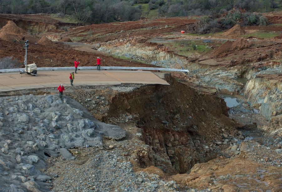
As Oroville Lake filled to near capacity, water was released over the dam's concrete main spillway. In doing so, a large hole developed in the spillway ramp.
Then erosion at the base of a nearby emergency (auxiliary) spillway threatened the stability of the spillway wall which holds back billions of gallons of water. That led to an evacuation order for more than 100,000 residents in the path of the dam.
The main spillway was put back into use after a brief examination and water levels in Lake Oroville were brought down to safer levels.
But damage was fairly extensive to both spillways.
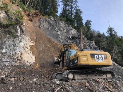
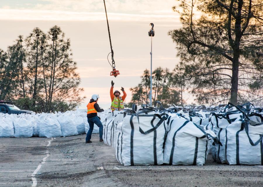
Using helicopters and bulldozers, crews worked to fill in eroded areas near the emergency spillway wall. As of Feb. 23, they had brought in 100,000 cu. yds. (76,455.5 cu m) of rock and sand and 11,600 cu. yds. (8,868.8 cu m) of cement, which was poured over the rocks and sand.
The main spillway needed further examination to determine if the hole could be repaired or if a new spillway would need to be constructed.
“In a couple of days, we will examine it to determine repairs,” said Chris Orrock, information officer of the California Department of Water Resources.
Meanwhile work continued on filling holes and stabilizing the area near the emergencyCalifornia's Department of Water Resources is looking ahead on how it can fortify and improve Oroville Dam's spillways to prevent future water damage and threat of catastrophic flooding.
The department and downstream residents had quite a scare in early February after the area was hit hard by a series of drenching winter storms. Lake Oroville is about 75 mi. north of Sacramento and about 25 mi. southeast of Chico. The dam is the tallest in the United States.
As Oroville Lake filled to near capacity, water was released over the dam's concrete main spillway. In doing so, a large hole developed in the spillway ramp.
Then erosion at the base of a nearby emergency (auxiliary) spillway threatened the stability of the spillway wall which holds back billions of gallons of water. That led to an evacuation order for more than 100,000 residents in the path of the dam.
The main spillway was put back into use after a brief examination and water levels in Lake Oroville were brought down to safer levels.
But damage was fairly extensive to both spillways.
Using helicopters and bulldozers, crews worked to fill in eroded areas near the emergency spillway wall. As of Feb. 23, they had brought in 100,000 cu. yds. (76,455.5 cu m) of rock and sand and 11,600 cu. yds. (8,868.8 cu m) of cement, which was poured over the rocks and sand.
The main spillway needed further examination to determine if the hole could be repaired or if a new spillway would need to be constructed.
“In a couple of days, we will examine it to determine repairs,” said Chris Orrock, information officer of the California Department of Water Resources.
Meanwhile work continued on filling holes and stabilizing the area near the emergency pillway. Initial estimate for that work was approximately $100 million, but officials reported the cost could go higher.
Contractor for the work is Syblon Reid Contractors of Folsom, Calif.
Syblon Reid is experienced in a variety of major projects including hydro generation and water conveyance, hydro technical services, bridge work, treatment plants and pump solutions, site work, environmental enhancements and emergency response. Its motto is “Providing solutions to difficult projects,” which is fitting in regard to the problems at Oroville Dam.
Timeline of Events
Jan. 31: Flows through the dam's concrete main spillway at Oroville Dam reached 10,000 cu. ft. per second, increasing water flow into the Feather River.
Feb. 7: The flow over the spillway was increased to 54,500 cu. ft. per second to offset higher inflows from rainfall. On the same day, part of the main spillway unexpectedly collapsed into the ground as water was being released from the lake.
Crews temporarily closed off the flow so damage could be examined. With water levels continuing to rise, engineers decided to use the damaged main spillway, but with reduced flows.
Feb. 11: With the elevation of Lake Oroville at 901 ft., water levels topped the emergency or backup spillway, which is a concrete wall designed as a last-ditch resort to drain the lake when it becomes too full.
As water poured over the wall and pounded the ground below, DWR officials became concerned that erosion could undermine the barrier. That could cause the concrete wall to collapse, causing a 30-ft. wall of water to rush into the Feather River.
It was the first time that water flowed over the emergency spillway since the dam was completed in 1968.
Feb. 12: Officials detected a large hole where earth was eroding away a path of dirt toward the concrete retaining wall.
More than 100,000 people were ordered to flee to higher ground. The evacuation area included Oroville and Yuba City.
Frantic to lower the reservoir level and stop water flowing down the emergency spillway, DWR decided to increase the amount of water flowing out of the main spillway to 100,000 cu. ft. per second to draw down the water level.
If the 30-ft.-high concrete barrier at the top of the auxiliary spillway collapsed, billions of gallons of water would burst from the reservoir all at once.
Feb. 14: State water officials continued to lower the level of Lake Oroville in anticipation of a series of storms that were forecast to hit.
By 7 a.m., Department of Water Resources' crews had lowered the reservoir level by at least 11 ft. Authorities lifted the mandatory evacuation order, but asked residents to be prepared in case another evacuation was needed.
Crews Repair Some Damage
Efforts were then undertaken to make repairs to both the primary and emergency spillways. A temporary flight restriction order was enacted for the area of the Oroville Dam as crews conduct continual surveys. This restriction included use of recreational drones.
From Feb. 14 to Feb. 15, dump trucks and helicopters dropped rocks and sandbags to shore up the emergency spillway. Helicopters dumped rocks in a staging area where the rocks were put on dump trucks and carried to the area where erosion occurred below the concrete wall.
It required about 90 workers a day, although the number fluctuated, and placement of more than 1,200 tons (1088.6 t) of rocks and sandbags.
By Feb. 16, the water flow over the main spillway had been reduced enough for crews to clear debris from the bottom and prepare to restart the dam's hydroelectric plant.
The DWR reported that it was focusing on ways to get the Hyatt Power Plant back online, because it can release 14,000 cu. ft. per second once in operation, taking pressure off the spillways.
Power generation was halted when the water levels in the channel that leads from the power plant became high enough to compromise operation.
Lake Level Dropped Substantially
By Feb. 18, the level of the lake had dropped to 854 ft. and the main spillway outflow was down to 55,000 cu. ft. per second.
Total discharges from the reservoir remain consistent with flood control releases at this time of year under these weather conditions. DWR does not expect the discharge from the reservoir to exceed the capacity of any channel downstream.
Hole in Main Spillway
Time was of the essence in cutting the emergency spillway water flow. The damage consists of a hole, 250 ft. (76.2 m) long, 170 ft. (51.8 m) wide and 40 to 50 ft. (12 to 15 m) deep.
At a news conference, Bill Croyle, acting director of the California Department of Water Resources, said there was not enough time to allow the main spillway chute to dry and then repair the damage.
Officials determined they had no choice other than to use the crippled main spillway despite the threat of further damage.
Fortunately, the decision paid off in lowering the lake level.
Breathing a Sigh of Relief
Loss of valuable water could have posed a major problem. Lake Oroville is the prime source of water for the state's Central Valley Water project, providing 61 percent of supplies. The water flows to Southern California and the Bay Area, as well as to Central Valley farmers.
Losing the reservoir would put parts of California in an extreme water shortage situation.
Looking Long Term
Now DWR officials must decide whether to repair or replace the main spillway. And if replacement is necessary, they must decide if it should be moved to another location.
Croyle indicated that all options are on the table.
Trump Administration Keeping Close Eye on Situation
At a news briefing Feb. 14, White House Press Secretary Sean Spicer said President Trump has been “keeping a close eye” on the Oroville Dam emergency and is working with the Federal Emergency Management Agency to assist state officials.
Spicer described the Oroville emergency as a textbook example of why a major infrastructure package is needed in Congress.
The White House was working with Rep. Doug LaMalfa, (R), Richvale, Calif., whose district includes Oroville and surrounding communities, to help communities affected by the emergency.
Other California Dams in Need of Repair
Although the focus is currently on Oroville Dam, California is also concerned about status of the dam at Lake Isabella. It was built in the 1950s along the Kern River northeast of Bakersfield on what was thought to be a dormant earthquake fault by the Army Corps of Engineers.
Engineers have now determined that the fault is active, so authorities restricted the level of the lake behind it. Officials have assured nearby residents that despite recent heavy rains, the lake levels and the dam itself, remained safe.
But the dam will have to be rebuilt, with a new emergency spillway, at a cost estimated at about $500 million. Construction is expected to start this year and to take at least five years to complete.—CEG
Construction Equipment Guide
470 Maryland Drive
Fort Washington, PA 19034
800-523-2200
Construction Equipment Guide covers the nation with its four regional newspapers, offering construction and industry news and information along with new and used construction equipment for sale from dealers in your area. Now we extend those services and information to the internet. Making it as easy as possible to find the news and equipment that you need and want.
Contents Copyrighted 2024, by Construction Equipment Guide, which is a Registered Trademark, registered in the U.S. Patent Office. Registration number 0957323. All rights reserved, nothing may be reprinted or reproduced (including framing) in whole or part without written permission from the publisher. All editorial material, photographs, drawings, letters, and other material will be treated as unconditionally assigned for publication and copyright purposes and are subject to Construction Equipment Guide’s unrestricted right to edit and comment editorially. Contributor articles do not necessarily reflect the policy or opinions of this publication.
Read our privacy policy here.
Mastodon