


Our Main Office
Construction Equipment Guide
470 Maryland Drive
Fort Washington, PA 19034
800-523-2200
Mon November 07, 2016 - Southeast Edition #23

Heavy-duty rain and surf from a hurricane generally means heavy-duty equipment will be called in for repairs.
That is certainly the case in the aftermath of Hurricane Matthew, which roared northward up the southeast coast of the United States the second weekend in October.
At one point the storm system was rated as a Category 5 hurricane while plowing through the Caribbean. By the time it moved into American waters, it had lost some punch, but was still a dangerous and destructive Category 3.
The effects of Matthew on the entire southeastern United States will undoubtedly last for several months, as the storm killed dozens and did an estimated $8.1 billion in damage.
Another $2 billion in damage was inflicted on the western Caribbean nations, most grievously in Haiti, which counted at least 1,600 dead as the storm churned across its southwestern coast on the morning of Oct. 4.
Days later, Matthew took dead aim on the U.S. coast before systematically hitting Florida, Georgia, South Carolina and North Carolina.
All four states saw destruction and loss of life, but none worse than the Tarheel State.
Hundreds of roads and bridges were chewed up or simply washed away by record-breaking inland rain in North Carolina and areas just across the border in northeastern South Carolina.
Further south in Florida, Georgia and coastal areas of South Carolina, the biggest problem was wind and storm surge as the hurricane slammed ocean water into sand dunes, seawalls and low-lying areas from Fort Pierce, Fla., all the way to Cape Hatteras.
In the days preceding the storm's arrival, evacuations were ordered, repair crews were put on emergency standby and the metropolitan areas of Daytona Beach, Jacksonville, Savannah, Charleston and Myrtle Beach all braced for the prospect of winds up to 150 mi. (241 km) per hour and devastating storm surge.
Florida
The Sunshine State's beaches and barrier islands, in particular, were predicted to be in serious danger from the expected storm surge, prompting thousands of people to heed Gov. Rick Scott's warning to leave.
As it happened, the weakening storm stayed far enough offshore that the winds were not as bad as feared. Still, with Matthew only about 40 mi. (64.3 km) off the coast at Cape Canaveral, Fla., 80 mph winds damaged roofs and did several million dollars worth of destruction at the Kennedy Space Center.
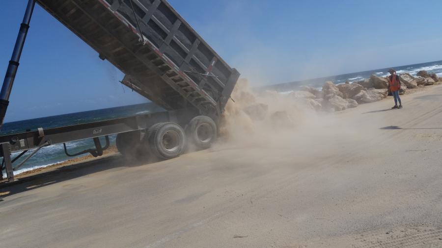
The pounding Atlantic surf caused erosion and damage at almost every beach in central and north Florida, with the towns of Indialantic, Daytona Beach, Flagler Beach, St. Augustine and Fernandina Beach seeing protective dunes ravaged and in need of restoration by off-road trucks, backhoes and dozers.
All told, about 15 percent of the state's East Coast sand dunes were destroyed and 53 mi. (85.2 km) of dunes were overtopped by the storm.
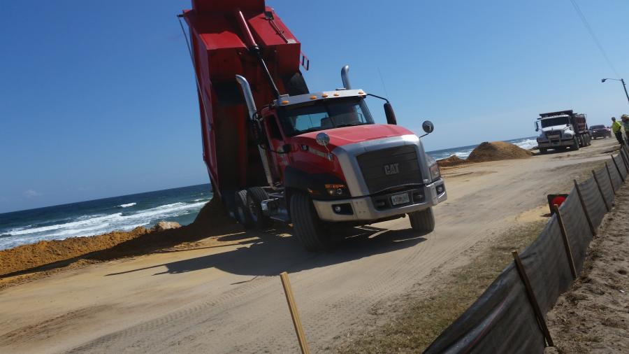
Flagler Beach was the scene of one of the more high-profile examples of Matthew's wrath in the state when storm surge there collapsed a 1.3-mi. (2 km) section of state Road A1A. The highway runs right along the beach, but pounding waves crumbled and then washed away the highway at several spots.
After visiting the site shortly after the hurricane moved through, Gov. Scott ordered the repair work to be expedited in order to help the beach community — heavily dependent on tourism — to recover.
Work began on Oct. 24 to reopen the road to two-lane traffic within 45 days, according to the Florida DOT.
Halifax Paving, from nearby Ormond Beach, was selected to do the temporary repairs from among five bidders. The cost of the contract is $3.95 million.
The FDOT believes that the cost of a permanent replacement for the four-lane road could be as much as $35 million and take as long as a year to complete.
Georgia
Officials and residents in the Peach State feel they dodged a major catastrophe as the weakened hurricane skirted the Georgia coast, but that did not mean the state avoided damage. Top winds of 96 mph, recorded near Savannah, combined with storm surge and heavy rain to bring the region to its knees.
The area from Brunswick to Savannah, part of the state's low country, took the brunt of the tempest. Many areas east of I-95 experienced extensive flooding with portions of Chatham County seeing 17 in. (43 cm) of rainfall.
“Fortunately, we didn't get the hit from Matthew that we thought we would, but in those low-lying areas around Brunswick we do have some road work to do,” said Natalie Dale, an official with the Georgia DOT.
Just east of Savannah, Skidaway Island and Tybee Island were raked by high winds, storm surge and record flooding. Fort Pulaski, a Civil War-era embattlement at the mouth of the Savannah River, was surrounded by 5.1 ft. (1.5 m) of water above the average highest tide.
Roads and bridges in the Brunswick area, including those that connect the mainland with the resort communities on St. Simon's and Jekyll islands, were cleared of debris and inspected for structural damage. GADOT crews were able to quickly get those routes open again for residents and tourists.
Much more damage was done to docks and marinas in several cities and small towns along the Georgia coast.
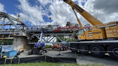
A good example of the storm's destruction was in Brunswick, where a local company, Sea Tow, was brought in to raise an old shrimp boat that had been slammed against the town's docks by Hurricane Matthew.
The vessel, Three Girls, sank in the Brunswick River after being buffeted by high winds from the northwest and tossed repeatedly against the wooden bumpers of its berth before going under.
Sea Tow Brunswick partnered with its sister company in Pensacola, Fla., to bring in people and equipment to do the job. In addition, a sub-contractor, Salonen Marine Inc., Fernandina Beach, Fla., moved its American 100-ton (90.7 t) crane with a supporting barge to the wreck site.
After crews cut away and removed the damaged rigging on Three Girls, the American crane hoisted the vessel out of the water on Oct. 26.
A total of about a dozen people, made up of an equal number of personnel from all three companies involved, completed the salvage operation, according to Henry Wynn, Sea Tow Brunswick's operations manager. That included divers, rigging crews and deck hands.
Wynn described the recovery of the Three Girls as a two-day job after the logistics were worked out and the equipment was delivered to the site.
“Once we cleared the gunwales and got her raised with the crane, we de-watered her for several hours with five or six pumps,” he said. “When it was determined that there was not any major structural damage to her hull, we then towed her to a yard to be scrapped.”
South Carolina
As if it were reading a map, Hurricane Matthew turned more northeastward to follow the Atlantic coastline as it crossed over into the Palmetto State, again staying just offshore.
If anything, though, the storm's destruction was just beginning.
Eighty-five mph winds and a 7-ft-storm surge flooded the state's famed Low Country, an area that includes Hilton Head Island and the barrier islands around Charleston. The city itself saw ocean water breach a seawall and flood several neighborhoods.
Finally, Matthew made its first, and only, landfall in the United States as a Category 1 storm at Cape Romain National Wildlife Refuge, north of Charleston, on the morning of Oct. 8. It then began moving back off the coast, but not before dumping incredible amounts of rain in the area west of the hurricane's eye.
Roads became blocked with debris and flood waters along the state's coastal region and northeast inland, leaving the SCDOT with months of cleanup and repairs in its future.
“We had about 441 road closures after the storm and we are down to about 54 today [Oct. 26],” said Pete Poore, communications director of SCDOT. “The biggest problem was in that northeast corner of the state, away from the coast. We still have a number of roads underwater there and we don't know the extent of their damage yet.”
Poore listed the counties of Marion, Dillon and Florence as among those hardest hit by flooding. The small town of Nichols, with only 400 residents, was completely evacuated after the nearby Lumber River flooded homes and businesses to their rooflines.
A few spots along I-95 were washed out by flood waters along the Pee Dee River system, but Poore said they were fixed and open within a day or two.
Farther south in the Low Country, a number of barrier islands, such as Ladys Island and Harbor Island, had damage to the approaches to key bridges, but not to the spans themselves. Poore said that those repairs have been completed.
“Even though assessments are still being made in the flooded counties, a handful of bridges will have to be awarded to contractors for repairs,” he said.
Right now, the SCDOT is working on most repairs and clean up with its own maintenance crews.
“Part of the reason for the rapid reopening of roads here is that we had crews standing by in the upstate region, which saw little to no damage, before the storm,” Poore said. “Sign crews and signal crews were sent in to the northeast area quickly. They also sent bridge inspectors to rotate in with the local crews and that has helped immensely.”
North Carolina
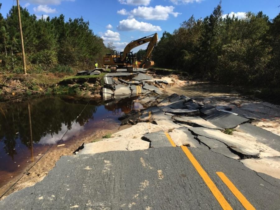
Coastal wind and storm surge are a given in any hurricane, but the amount of rain generated miles inland in North Carolina's I-95/I-40 corridor took everyone by surprise. By late October, the state estimated its flooding damage alone would exceed $1.5 billion.
Assessments in North Carolina are still being made as flood waters slowly recede after the immense amount of rain that hit on Oct. 8. As much as 15 to 18 in. (38 to 45 cm) fell in many communities in and around I-95 from the South Carolina border north to the Rocky Mount area.
A number of river systems in the state reached record flood stages in the two weeks after the hurricane dissipated, including the Lumber, Neuse, Tar and Lower Little. People living in the cities and towns of Fayetteville, Greenville, Kinston, Goldsboro, Smithfield, Rocky Mount, Manchester, Princeville and Lumberton all saw homes and businesses under water.
The NCDOT reported that more than 600 roads were closed in the state when the flood waters were at their worst, but according to Steve Abbott, communications officer of the agency, by Oct. 26 that number had been reduced to about 350. Many of those are in the Lumberton area, which garnered much of the national attention due to its severe flooding.
“Once the water recedes, we have had to go out and inspect all the roads and remove any debris,” he said. “The inspection process is important because in a lot of cases the road surfaces have been okay, but there is nothing underneath them because the culverts have washed away. Most of the deaths in our state have come as a result of people driving around those barricades and being swept away.”
Because of the disaster, the NCDOT is able to move quickly to get contractors lined up to do the repair and recovery work, Abbott said. Although many key roads and bridges are already fixed and traffic is moving, such as on the affected interstates, many others will take months to be put back in working order.
“There are no temporary fixes with these roads,” Abbott said. “Once they are washed out, they need to be repaired for the long haul.”
Another high profile road in the state that was addressed quickly was N.C. 12, the only major road running along the Outer Banks. The two-lane road travels along a narrow spit of land that in many places has the Atlantic Ocean on one side and Albemarle Sound on the other.
Matthew caused an abnormally high tidal surge that overwashed and crumbled about 125 ft. (38 m) of the highway in Kitty Hawk. Crews were able to come in and begin repairs, with the NCDOT hoping the job would be finished in the first week of November.
Good Riddance
The outer bands of Matthew then raked through the far eastern Virginia, where it killed two people and caused street flooding, before moving out into the Atlantic and dissipating on Oct. 10.
Undoubtedly, the hurricane was not as devastating as predicted because of its remaining offshore for most of its track. But for all those folks whose lives were shattered by the flooding, death and destruction caused by Matthew, that fact provides little comfort.
Construction Equipment Guide
470 Maryland Drive
Fort Washington, PA 19034
800-523-2200
Construction Equipment Guide covers the nation with its four regional newspapers, offering construction and industry news and information along with new and used construction equipment for sale from dealers in your area. Now we extend those services and information to the internet. Making it as easy as possible to find the news and equipment that you need and want.
Contents Copyrighted 2024, by Construction Equipment Guide, which is a Registered Trademark, registered in the U.S. Patent Office. Registration number 0957323. All rights reserved, nothing may be reprinted or reproduced (including framing) in whole or part without written permission from the publisher. All editorial material, photographs, drawings, letters, and other material will be treated as unconditionally assigned for publication and copyright purposes and are subject to Construction Equipment Guide’s unrestricted right to edit and comment editorially. Contributor articles do not necessarily reflect the policy or opinions of this publication.
Read our privacy policy here.
Mastodon