


Our Main Office
Construction Equipment Guide
470 Maryland Drive
Fort Washington, PA 19034
800-523-2200
Wed March 09, 2016 - National Edition
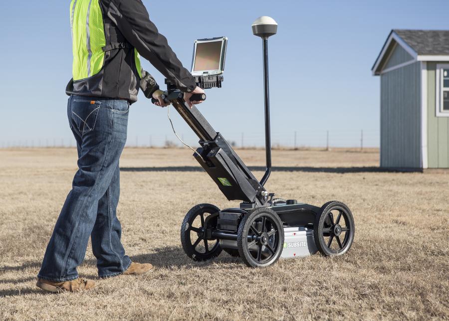
Subsite Electronics, a Charles Machine Works Company, has introduced the 2550GR Ground Penetrating Radar System featuring a new, user-friendly Window's-based interface that will provide operators with a number of productivity enhancing benefits.
“The 2550GR offers all the same great features as our proven 2450GR,” said Matt Lumbers, product manager, utility locating systems, Subsite Electronics. “It's ideal for locating any type of utility conduit or piping—metallic or non-metallic, including PVC—beneath soil, rock, pavement, and other surfaces. Plus, we've added a number of important software upgrades that will simplify operation and improve performance.”
New software for the 2550GR is designed to make users more efficient. Easy GPS connectivity allows operators to see their path and marks in real-time as they scan. A new wireless connection enables users to easily download web-based maps such as Google Earth.
A new one-touch recalibration button lets operators transition from one scanning surface to another quickly and easily, while the earth-engaged antenna provides better contact on uneven terrain and reduces signal loss.
“We listened to users in the field and have been able to improve the operator experience with significant software upgrades,” Lumbers said.
The 2550GR locates both metallic and non-metallic pipes and cables to allow one-pass locates at depths of up to 19.7 feet (6 m), depending on soil conditions and antenna selection. A 5.6 mph (9 km/h) survey speed and digitally controlled radar allow the 2550GR to provide fast, clear images.
In addition to utility mapping efforts, the 2550GR's advanced locating capability makes it ideal for a wide range of other applications including void and sinkhole detection, concrete detection, and locating underground storage tanks.
For more information on this product and Subsite Electronics, visit www.subsite.com.
Construction Equipment Guide
470 Maryland Drive
Fort Washington, PA 19034
800-523-2200
Construction Equipment Guide covers the nation with its four regional newspapers, offering construction and industry news and information along with new and used construction equipment for sale from dealers in your area. Now we extend those services and information to the internet. Making it as easy as possible to find the news and equipment that you need and want.
Contents Copyrighted 2024, by Construction Equipment Guide, which is a Registered Trademark, registered in the U.S. Patent Office. Registration number 0957323. All rights reserved, nothing may be reprinted or reproduced (including framing) in whole or part without written permission from the publisher. All editorial material, photographs, drawings, letters, and other material will be treated as unconditionally assigned for publication and copyright purposes and are subject to Construction Equipment Guide’s unrestricted right to edit and comment editorially. Contributor articles do not necessarily reflect the policy or opinions of this publication.
Read our privacy policy here.
Mastodon