


Our Main Office
Construction Equipment Guide
470 Maryland Drive
Fort Washington, PA 19034
800-523-2200
Tue September 26, 2017 - National Edition
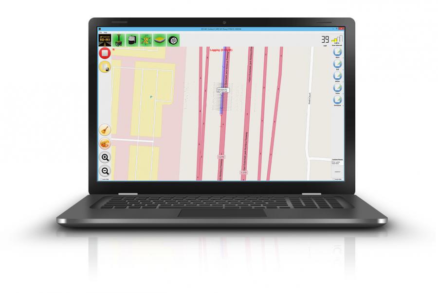
Topcon Positioning Group recently announced an update to its data collection software for the SmoothRide resurfacing workflow solution. RD-M1 Collect 2.0 includes updates designed to facilitate and optimize mapping of road conditions.
The improvements feature an improved interface that is designed to simplify setup and automatically detect the position of the wheel sensor during data collection.
"Operators can now take advantage of the RD-M1 Collect 2.0 graphical interface status bar that indicates the optimum speed for collecting road information based on the project requirements," said Kris Maas, director of construction product management. "Capturing at proper speed helps enable SmoothRide to deliver the best possible results for the project."
Memos is a new feature designed to allow operators to easily create balloons with messages onto the map while collecting data that also can be made visible in the processing software — enabling specific site conditions to be noted for future reference.
The new Manage Runs feature is designed to enable operation without necessitating Windows Explorer to be open.
"The large buttons make using a tablet or laptop with touch screen very easy," said Maas. "Operators can copy data collections to a USB drive, delete them from the hard drive, and add or remove them from the manager."
The RD-M1 Collect 2.0's new Plan Route feature allows for the import of kml files of predetermined routes, designed to help ensure nothing is missed on the drive.
"Using the new map downloader, operators can be assured of having all map details visible while collecting data, without the need of an internet connection. Additionally, overlapping locations can be managed by creating areas where predefined overlaps are required for the project," said Maas.
For more information, visit topconpositioning.com.
Construction Equipment Guide
470 Maryland Drive
Fort Washington, PA 19034
800-523-2200
Construction Equipment Guide covers the nation with its four regional newspapers, offering construction and industry news and information along with new and used construction equipment for sale from dealers in your area. Now we extend those services and information to the internet. Making it as easy as possible to find the news and equipment that you need and want.
Contents Copyrighted 2024, by Construction Equipment Guide, which is a Registered Trademark, registered in the U.S. Patent Office. Registration number 0957323. All rights reserved, nothing may be reprinted or reproduced (including framing) in whole or part without written permission from the publisher. All editorial material, photographs, drawings, letters, and other material will be treated as unconditionally assigned for publication and copyright purposes and are subject to Construction Equipment Guide’s unrestricted right to edit and comment editorially. Contributor articles do not necessarily reflect the policy or opinions of this publication.
Read our privacy policy here.
Mastodon