


Our Main Office
Construction Equipment Guide
470 Maryland Drive
Fort Washington, PA 19034
800-523-2200
Tue October 18, 2022 - Southeast Edition #22
A dredging company began construction Oct. 11 on a 1,500-ft.-wide underwater levee designed to block a wedge of Gulf of Mexico saltwater from reaching public and industrial water supply intakes on the Mississippi River in Plaquemines Parish and New Orleans.
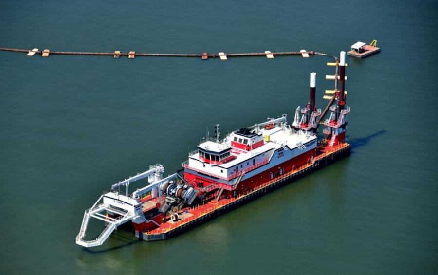
The U.S. Army Corps of Engineers (USACE) announced in a news release that Weeks Marine Inc., which has a regional office in Covington, La., has moved its JS Chatry dredge and associated barges and pipelines into place just north of the Phillips66 Alliance Refinery site.
From there, the company will dredge sediment from the bottom of the river and pump it to a location near Myrtle Grove to build the underwater structure, known as a "sill."
Corps officials declined to disclose the price of the dredging contract to NOLA.com, the online site for the New Orleans Times-Picayune, but earlier in October the USACE estimated the project would cost about $10 million.
The Mississippi River at the Myrtle Grove location is around 90 ft. deep, and the wide earthen structure could rise as much as 45 ft. from the river's bottom. That could require ocean-going vessels, which often have 50-ft. drafts, to reduce the amount of cargo they are holding, or to unload part of the cargo south of the sill, to avoid running aground on it or damaging it.
The U.S. Coast Guard and the USACE are coordinating with vessel operators to assure the sill construction's effects on shipping are limited, according to NOLA.com.
The Gulf of Mexico's saltwater is able to move up the river because of a lack of rainfall this spring, summer and fall in the upper Mississippi, Ohio and Missouri river valleys. The Mississippi's low flow lets the saltwater creep slowly upriver beneath the river's fresh water.
The USACE estimated the leading "toe" of the saltwater wedge was already at mile marker 57.2 on Oct. 11, but officials said the higher part of the wedge that could cause problems for water intakes was about 20 mi. farther south.
"Throughout the construction phase, the Corps will test salinity levels in the river to determine where the saltwater wedge is and how high the sill may need to be built," according to the USACE statement.
Saltwater has reached a Plaquemines water plant in Boothville, and will eventually spread to one in Pointe a la Hache, both of which are south of the sill. A drinking water advisory is already in effect for residents using water from the Boothville facility due to elevated levels of sodium and chlorate in the water.
NOLA.com reported that Plaquemines Parish officials have not yet announced whether reverse osmosis water treatment units it was trying to lease have arrived for installation at the two lower river water plants.
Construction Equipment Guide
470 Maryland Drive
Fort Washington, PA 19034
800-523-2200
Construction Equipment Guide covers the nation with its four regional newspapers, offering construction and industry news and information along with new and used construction equipment for sale from dealers in your area. Now we extend those services and information to the internet. Making it as easy as possible to find the news and equipment that you need and want.
Contents Copyrighted 2024, by Construction Equipment Guide, which is a Registered Trademark, registered in the U.S. Patent Office. Registration number 0957323. All rights reserved, nothing may be reprinted or reproduced (including framing) in whole or part without written permission from the publisher. All editorial material, photographs, drawings, letters, and other material will be treated as unconditionally assigned for publication and copyright purposes and are subject to Construction Equipment Guide’s unrestricted right to edit and comment editorially. Contributor articles do not necessarily reflect the policy or opinions of this publication.
Read our privacy policy here.
Mastodon