


Our Main Office
Construction Equipment Guide
470 Maryland Drive
Fort Washington, PA 19034
800-523-2200
Mon July 13, 2015 - West Edition
During mid-February 2013, a landslide along U.S. 89 in northern Arizona made it necessary for traffic to follow a 115 mi. (185 km) detour to travel from Bitter Springs to Page.
The landslide, which was next to a mountain slope about 25 mi. (40 km) south of Page, caused about 500-ft. (152.4 m) of damage, causing more than 150 ft. (45.7 m) of roadway to buckle and the slope to fail and tear up the pavement in 4 to 6 ft. (1.2 to 1.8 m) high sections. It was then necessary for the Arizona Department of Transportation to close a 23-mi. (37 km) stretch of U.S. 89 between the U.S. 89A junction near Bitter Springs and the state route 98 junction near Page.
Traffic was detoured by the ADOT east on U.S. 160 to State Road 98 and northwest on State Road 98 for 65 mi. (104.6 km) to Page, adding an additional 45 mi. (72.4 km) for motorists traveling from Bitter Springs to Page, making their trek 115 mi. (185 km) long. To attempt to shorten the trek, traffic was choosing Navajo Route 20, which is a dirt road that was causing trucks to get stuck.
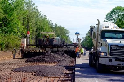
It was decided that it would be best to pave a 28-mi. (45 km) portion of Navajo Route 20, which is 44 mi. (70 km) long, to create a shorter detour that could handle anticipated traffic volumes and commercial truck traffic. Navajo Route 20 runs parallel to U.S. 89 from Bodaway-Gap to LeChee and is accessible from U.S. 89 about 17 miles north of the U.S. 160 junction, or the Tuba City exit. This $35 million project began at the end of May 2013 with a temporary construction easement. Tribal processes generally take months or even years to complete but ADOT’s easement was processed within weeks with assistance from the Federal Highway Administration, Navajo Nation, Navajo Division of Transportation and the Bureau of Indian Affairs, according to the Arizona Department of Transportation.
The U.S. 89 emergency repair project is eligible for reimbursement through the Federal Highway Administration’s emergency relief program, which provides funding to state and local agencies for the repair or reconstruction of highways, roads and bridges that are damaged in natural disasters and catastrophic failures, according to information from the ADOT.
“Typically a project of this magnitude could easily take over a year to finish, but the project was completed in roughly three months with crews from FNF Construction of Tempe, Arizona, working day and night shifts to complete the project as soon as possible,” said Dustin Krugel, statewide public information officer with ADOT.
“The contractor also used two separate earthwork and paving crews to complete the work. One crew worked from south to north while the other worked from north to south. Eventually the two crews met in about the middle of the project,” Krugel said.
Prior to construction, the detour route was open only to daytime use and speed restrictions were in place in the areas where fencing had not been completed.
So in late 2013, the 28-mi. were paved and the 44-mi. detour along Navajo Route 20 was opened. As long as the road is being used as a detour it will be maintained by ADOT and named U.S. 89T. Once it is no longer needed as a detour it will be turned back over to the Navajo Nation and resume the name of Navajo Route 20.
The landslide, which was caused by the reactivation of a small portion of an ancient landslide, occurred in the Echo Cliffs area, which is a popular hiking area north of Flagstaff in the Grand Canyon National Park area. Geotechnical engineers assessed the stability of the ground after the landslide on U.S. 89, which was originally built in 1957 by the U.S. Bureau of Reclamation. An engineering design firm then created plans for the repair, taking into account cultural, biological and water quality needs. Before creating a design to make necessary repairs, it was necessary to drill shafts to deploy equipment to measure slope movement to determine if the area was stable, information from the Arizona Department of Transportation states.
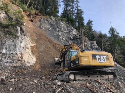
Engineers determined it would be necessary to construct a downslope buttress along the lower slope to stabilize and reinforce the mountain slope that carries the new roadway and move the travel lanes about 60 ft. (18 m) away from the landslide area toward Echo Cliffs by cutting into the cliff, Krugel said. The $25 million project began in mid-2014.
The buttress was created with the material that was excavated from the landslide area. Crews with FNF Construction blasted and hauled about one million cubic yards of soil and rock material. Rock materials were transported to the base of the landslide area on the west side of U.S. 89 to construct the buttress, which is about 1,400 ft. (426.7 m) long and 100-ft. (30.5 m) high, Krugel said.
Equipment used included Caterpillar 773 haul trucks, Caterpillar 349 track hoes, Caterpillar 988 front end loaders, Caterpillar D10 bulldozers, Caterpillar 14H graders and Volvo A40G haul trucks.
“Due to the amount and type of material that needed to be moved, large excavators and haul trucks, like the types used in open pit mines, had to be used,” Krugel said. “Having such large equipment in a relatively small work area was one of the biggest challenges. Between the blasting, excavating and hauling operations, we had to make sure each operation could work around the others without getting in each other’s way.”
Crews also had to work around some steep grades and prevent rocks from endangering workers below and keep crews and equipment from falling over the edge, Krugel added.
Once the earthwork was complete, crews started building the foundation of the newly aligned 1,500-ft. (457.2 m) section of U.S. 89. The ground surface was graded to the proper elevations and then just over 4,100 cu. yd. (3134.7 cu m) of aggregate base was placed and compacted, Krugel said. “On top of that we placed about 5,700 tons (5,171 t) of asphaltic concrete for the base course, which was topped with about 450 tons of asphaltic friction course.”
To monitor possible future geological movements, inclinometers were installed in the new buttress.
Work was completed on U.S. 89 in late March and opened to traffic, while crews returned in mid-April to finish the final lane striping.
“Due in part to mild winter and favorable weather conditions, the actual repair project finished about a month and a half ahead of the planned schedule, Krugel said.
Construction Equipment Guide
470 Maryland Drive
Fort Washington, PA 19034
800-523-2200
Construction Equipment Guide covers the nation with its four regional newspapers, offering construction and industry news and information along with new and used construction equipment for sale from dealers in your area. Now we extend those services and information to the internet. Making it as easy as possible to find the news and equipment that you need and want.
Contents Copyrighted 2024, by Construction Equipment Guide, which is a Registered Trademark, registered in the U.S. Patent Office. Registration number 0957323. All rights reserved, nothing may be reprinted or reproduced (including framing) in whole or part without written permission from the publisher. All editorial material, photographs, drawings, letters, and other material will be treated as unconditionally assigned for publication and copyright purposes and are subject to Construction Equipment Guide’s unrestricted right to edit and comment editorially. Contributor articles do not necessarily reflect the policy or opinions of this publication.
Read our privacy policy here.
Mastodon