CHELAN, Wash. (AP) Ruggedly beautiful, the rocky channel and gorge once guided the free-flowing Chelan River from its origin at the southernmost tip of Lake Chelan along a rolling-and-tumbling course to the Columbia River, 4 mi. (6.4 km) and more than 400 ft. (121 km) below.
Biologists say northern pikeminnow, chub and possibly cutthroat trout inhabited the river’s upper reach the approximately 2-mi. (3.2 km) stretch below where the dam is today.
Osprey would circle for fish. Deer and rabbits would venture down for a drink and to nibble on the hardy wheatgrass and sage that softened the harsh desert climate. Cougars would pad down to capture a meal.
The Lake Chelan Hydro Project, completed in 1927, blocked the river, dried up the gorge for most of the year and destroyed much of the hardscrabble diversity.
But more than eight decades later, this dry and unforgiving ecosystem is about to make a comeback.
The Chelan County PUD is at work on a $13.8 million project to restore a year-round flow to the Chelan River and retool its lowest reach to lure spawning steelhead and chinook salmon to areas where they may never have spawned before.
Plans include a nature trail and picnic area in the river’s upper reach and four yearly whitewater events in the gorge for expert kayakers.
The rehab project is part of $60 million to $65.5 million in dam and other projects required by the PUD’s new 50-year federal dam license. The projects include overhauling the powerhouse’s two generating units, which produce 48 megawatts of electricity.
The Chelan Gorge rehab project is the product of years of debate that involved state and federal fish, wildlife and environmental agencies and a host of area community members.
Site work began in June and should be finished by fall 2009.
“I think it’s an absolute one-of-its-kind, fascinating, unique project,” said Jeff Osborn, a self-described PUD “biopolitician” for his roles as fisheries biologist and dam-license negotiator.
“The components we’re using have been done in small sections of other streams, but here we’re building a new stream with all the components — channel, bank, substrate, boulders, logjams. Any feature you see in a naturally functioning stream, we’re building from scratch.”
He added, “We’re going ahead with the best science and engineering, because there isn’t a model to copy anywhere.”
The completed project will restore Chelan River’s old, year-round flow at a slower rate. The planned flow of 80 cu. ft. per second is equivalent to the low-flow average of the Entiat River.
The flow will be increased to 300 to 450 cu. ft. per second for kayaking events in the gorge beginning next year.
The river’s lowest reach, near the dam’s powerhouse, will be redesigned into a meandering stream that combines the best attributes — water flows, temperature, vegetation and streambed gravel — to attract spawning steelhead and chinook salmon. These fish already spawn nearby, where the powerhouse tailrace channel merges into the Columbia River, just west of the Chelan Falls Road bridge. The new spawning habitat will cover about 2 acres.
The project also will add a 1.5-mi. (2.4 km) hiking trail extension to Chelan’s Riverwalk Loop Trail. The roughly horseshoe-shaped new trail will wind past the dam roughly south over rugged terrain into the Chelan River’s upper reach. It will then double back and head north along the Chelan River canyon. Picnic areas, viewpoints and informative nature signs will dot the way.
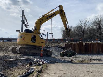
Wenatchee construction company Goodfellow Brothers is already at work using heavy equipment to dig, grade and sculpt the lower reach. All this work can be seen from Chelan Falls Road as it passes the powerhouse.
An environmental consulting firm with expertise in stream restoration has worked with PUD biologists to design the new “habitat stream” with carefully placed logjams, boulder groupings, plants, river topography and the gravel that migrating fish prefer.
An in-river barrier system of boulders and concrete will protect the habitat stream work from washing away under river flows that will routinely reach 2,000 to 6,000 cu. ft. per second when the dam is spilling in early summer and fall.
At the planned year-round flow of 80 cu. ft. per second, all the water coming out of the gorge will flow into the new habitat stream.
At higher flows, the project’s design will preserve the new stream’s 80 cu. ft. per second flow and direct excess flow into another, roughly parallel channel, creating a divided river.
Spawning steelhead and chinook also need faster flows, but they arrive during seasons when the dam isn’t usually spilling from mid-March to mid-May for steelhead and from mid-October to late November for chinook.
To speed up stream flow during these spawning seasons, the PUD will use a pumping system to supplement the 80 cu. ft. per second river flow already coming from the dam.
A new pumping station, across from the powerhouse, will pump water from the powerhouse tailrace through a canal to an outlet just upstream of the habitat channel, increasing the flow to about 320 cu. ft. per second.
The work at the top of the project, the dam, isn’t as complicated.
The Lake Chelan Hydro Project works via a 14- to 12-ft.-diameter (4.2 to 3.6 m) underground pipeline, called a “penstock,” that transports water from the dam 2.2 mi. (3.5 m) downhill to the powerhouse near the Columbia River.
The dam’s early engineers built a second pipeline into the dam in case future operators wanted to add a second penstock to feed more turbines at the powerhouse.
Water flows later proved insufficient for powerhouse expansion, Chelan Gorge project manager Bill Christman said.
To reintroduce year-round flow into the Chelan River, workers will build a new pipeline off this existing, 17-ft.-diameter (5.1 m) tunnel stub. They’ll extend the pipeline some 200 ft. (61 m) downstream from the dam, up and over the existing penstock to an outlet at the riverbed.
The new pipeline will carry cold water from the bottom of the Chelan River to the outlet downstream where it will cascade into the riverbed, year-round.
The cold water temperature is important, Christman said. If the water isn’t cold enough when it begins its downhill journey, the region’s hot, arid summers will overheat the water as it flows, making it too warm to support fish.
Christman said engineers ruled out simply spilling from the dam year-round to establish the constant flow, because in the summertime, surface river temperatures are too warm.
Also, the lake level sometimes dips lower than the dam’s spill gates, making it impossible to guarantee a year-round spill.
Eight decades of yearly, high-volume spill events have added to the problem.
Acting as flash floods, these high flows of 2,000 to 6,000 cu. ft. per second on average, with occasional historic spills of more than 20,000 cu. ft. per second, have scoured the riverbanks of vegetation that once helped prevent erosion and possibly provided some shade to cool the water.
The planned flow of 80 cu. ft. per second is much lower than the estimated 640 cu. ft. per second or higher that likely flowed through the undammed river, biologists say. But it’s a negotiated number, a volume of water considered adequate for fish habitat, without overly limiting recreation and hydropower generation, Osborn said.
The new, year-round flow won’t result in a greatly reduced production of electricity, PUD officials say. It won’t lower the level of Lake Chelan, nor will it affect the PUD’s seasonal adjustments of the lake’s levels to compensate for mountain snowmelt. At the planned year-round flow of 80 cu. ft. per second, the water exiting Lake Chelan will still be only about one-eighth of the water entering the lake from the Stehekin River at its lowest yearly average flow of about 640 cu. ft. per second, Department of Ecology statistics show. The Stehekin River is the largest of 23 streams feeding the lake.
PUD biologists will study the evolution of their Chelan River rehab efforts for 10 years to gauge their effects. They’ll issue yearly progress reports to federal hydropower authorities.
The Lake Chelan Hydro Project is probably one of the region’s least ecologically disruptive dams.
It doesn’t block the path of migrating fish, because salmon and steelhead were never able to navigate the steep, rocky gorge, many biologists say.
The project produces enough electricity to power some 20,000 homes, and its reservoir is a natural lake.
Studies funded by the PUD say that even before the dam was built, sometimes massive yearly floods scoured the river channel and gorge, washing away much vegetation.
At least two previous dams, built in 1892 and 1893 to raise the lake level for irrigation and steamboat navigation, already interrupted the river’s natural flow. Massive floods damaged both these rustic structures.
At its best, the river’s hot, rocky canyon topped by shrub-steppe habitat is harsh and unforgiving.
Why spend $13.8 million on an experiment to create barely 3 acres of additional spawning habitat that fish might not even use? Will the experiment even work?
“That was hotly debated,” the PUD’s Osborn said of a work group of biologists formed during the early and middle stages of dam relicensing. “Had we not felt it had a high likelihood of success, we never would have supported it for the life of the 50-year license.”
Today's top stories


