


Our Main Office
Construction Equipment Guide
470 Maryland Drive
Fort Washington, PA 19034
800-523-2200
Wed October 26, 2011 - Midwest Edition
Increasingly high water levels over the last several years is once again creating a need to raise road heights and build embankments to protect the city of Devils Lake in northeastern North Dakota. Combating the high water levels by raising road levels, moving structures and building levees has cost almost $1 billion over the years. More than 40 mi. (64.3 km) of road have been raised and some are now being raised even more, an 8-mi. (13 km) embankment has been built and is now being lengthened to 12 mi. (19.3 km), and about 300 homes and businesses have been relocated.
Devils Lake is a closed basin, meaning it has no inlet or outlet within the Red River Hudson Bay Drainage System, leaving the water level at the mercy of rain, evaporation or entering the groundwater table. The level of the lake has fluctuated from only 2 ft. (0.6 m) deep in 1940 to about 60 ft. (18.3 m) at some points now.
The low, flat terrain around Devils Lake consists of various coulees, channels and basins, which may be separated during times of low water, or connected during high water. Thus the boundaries of the lake can vary greatly from year to year, depending on the amount of precipitation.
Above average rains and snowfalls during the mid 1990s caused Devils Lake water levels to rise rapidly. In spring and summer 2009, the lake rose nearly 4 ft. (1.2 m) The lake elevation has continued to rise each year, creating an overall 26-ft. (7.9 m) increase in 13 years, claiming another 81,000 acres of adjacent, privately owned land. The lake now covers about 125,000 acres, according to information from the Devils Lake Area Chamber of Commerce.
In late June 2010, the lake crested at a new record high elevation just above 1,452 ft. (442.5 m) above sea level, with the top of the 8-mi. embankment protecting Devils Lake at 1,460 ft. (445 m), a level that was completed in December of 2005. Then in the spring of 2011 the lake rose about 3 ft. (0.9 m) to its current elevation of 1,454 ft. (443.1 m), according to information from the Devils Lake Area Chamber of Commerce.
Traditionally, the top 6 ft. (1.8 m) of level elevation serves as freeboard or a safety factor to prevent waves or ice from splashing over it, explained Bonnie Greenleaf, project manager with the U.S. Army Corps of Engineers in St. Paul, Minn.
The height required for the maximum pool elevation of 1,458 ft. (444.3 m) (where flows would begin out of the natural outlet at Tolna Coulee) is 1466 ft. (446.8 m) to meet dam safety standards. So, to meet those standards, the embankment is being lengthened from 8 mi. long to over 12 mi. (3.7 m), extending the embankment to high ground, and increasing its height to 1,466 ft. above sea level. The initial levees were constructed in the 1980s to an elevation of 1,445 ft. (440.4 m) above sea level. In 1996 the dikes were raised an additional 5 ft. (1.5 m) and in 1997 they were raised again, this time to 1,457 ft (444 m) to provide protection for a lake level of 1,451 ft. (442.2 m), according to information from the U.S. Army Corps of Engineers.
The lake began outletting into nearby Stump Lake at 1,446 ft. (440.7 m) This rise in water level has caused flooding to property and communities as well as transportation systems throughout the area. Water levels in Devils and Stump lakes are expected to continue to rise over the next decade, flooding more property, communities and transportation systems until the water level reaches 1,458 ft. (444.3 m), at which time the water begins to flow into the Sheyenne River via the Tolna Coulee, causing additional flooding issues for communities along the Sheyenne, according to information from the Devils Lake Area Chamber of Commerce.
To help combat the water, some roads are functioning as dams, protecting interior roads, property and homes, even though the roads were not designed or constructed to act as dams. Corrective measures have been identified to reinforce these roads so that they function safely and meet dam safety standards, according to information from the U.S. Army Corps of Engineers.
About 7 mi. (11.3 km) of highways 20 and 57 are being raised. This phase of construction will cost about $150 million, which is shared 75/25 by the federal government and the city of Devils Lake.
The embankment construction work is being phased so that an acceptable level of protection will be in place prior to the spring runoff of 2012. Embankments are being raised in four phases to reach 1,466 ft. Phase 1 was awarded in October of 2009; construction of a pump station head well is nearing completion.
Phase 2 was split into two contracts to allow for additional time to address geotechnical challenges. Phase 2a was awarded in November 2010 and will be completed in November 2011, which includes raising and lengthening the embankment, which is currently about half complete. The Federal Highway Administration and the Bureau of Indian Affairs are the lead agencies on this project, with technical support provided by the Corps of Engineers. Many of the roads are located within the Spirit Lake Indian Reservation.
Phase 3 was awarded in April 2011; Phase 2b was awarded in May 2011. All phases are scheduled to be completed by November 2012. Constructing the various embankment elevations has required tremendous amounts of materials. When creating the 1,457 ft. height in 1997, 1.8 million cu. yds. (1,376,199 cu m) was needed; and, to create the 1,460 ft. (445 m) height in 2005, about 160,000 cu. yds. (122,329 cu m) was required.
Lengthening the current 8 mi. embankment by 4 mi. (6.4 km) and increasing its height 6 ft. (1.8 m) requires about 2.6 million cu. yds. (1,987,843 cu m) of materials, including riprap, impervious fill, sand drain, bedding and top soil. The embankment is being constructed to a width of 20 ft. (6.1 m)
Some new techniques to construct the levee, due to Hurricane Katrina, have been incorporated such as creating a vegetative-free zone of 50 ft. (15.2 m), which can have nothing in it except turf, making it necessary to move utilities, Greenleaf said. In some areas the levees are being tied into the high ground.
“That is something that is stricter then in the past because since Katrina there is a lot of concern about levee standards,” she added.
A few challenges presented themselves over the last few years because the lake level is rising so quickly, creating the need for an aggressive schedule and a more technical design, Greenleaf said.
“We had to scramble and a lot of analysis had to go into this because technically this is a dam. Soil borings were taken and testing was done and we discovered that the materials were worse than we originally thought.”
This made it necessary for crews had to construct additional features like slurry trenches, which are created as impermeable groundwater barriers.
“Normally, when working on a dam and doing a project on a reservoir the water level is drawn down as much as possible so there is no big head of water on the other side; but, on this project that is not possible, which created a lot of pressure on the other side,” Greenleaf said.
Making sure the final product is stable places a lot of pressure on the contractors as to how they build the embankment.
Soil is hauled in from various borrow sites, which has been a huge challenge when extending the embankment and when raising the highway heights, Greenleaf said. The City of Devils Lake and the Spirit Lake Tribe has rules in effect on how deep can dig because they don’t want a bunch of holes that lake water could fill later.
“It has been difficult to find materials, since we have to be a little more particular in materials use. We want clay for its compaction properties, while sandy materials can be used on the highways. However, there are property owners who are willing to sell soil,” Greenleaf said.
Typically, a longer design period and a longer construction period would have been incorporated on a project of this type, but crews are concerned because of how fast the lake has risen in the last few years and how much it will rise over the upcoming winter.
“So if contractors don’t have the embankment raised to certain level we have to have temporary measures in place so waves aren’t splashing over embankment. At an elevation of 1,460 feet above sea level we have 6 feet of freeboard so the water is not above 1,454,” Greenleaf said. “It is a few tenths above that now, and if comes up next spring it will cause water to splash over the top. In the spring it looks like ocean waves on the highway and plows are scraping away the logs and rocks. We fortunately didn’t have damage to our rip rap because we use really big rock. We have to protect our embankment and be ready for possible issues.”
The water level increases in the spring and peaks during June but the Corps is hoping for a half foot or a foot of evaporation during the summer. Last year they were hoping for that too but it didn’t happen. The water level held to within a few tenths of where it had been. That level is holding steady between the evaporation and the excessive rains this summer.
Crews with Ames Construction Inc., of Burnesville, Minn., in conjunction with the North Dakota Department of Transportation, are working to raise a 7 mi. length of Highways 20 and 57, about 12 mi. south of Devils Lake. Work began in 2010 to raise the various locations along these two highways between 7 and 14 ft. (2.1 and 4.3 m), said Benjamin Lovin, project manager with Ames Construction. Prior to construction, lake water had increased to the point where it was up to the edge of the road, causing vehicle weight limits and speed reductions to 25 mph.
As of mid-September, work was about 60 percent complete with a scheduled completion of November. A late spring this year and a wetter than normal summer shortened the work season.
“Work on some portions will be a couple of weeks behind schedule, while work on other portions is actually ahead of schedule,” said Greg Semenko, assistant district engineer with the North Dakota Department of Transportation. “The contractors have done an excellent job in trying to meet the schedules, Some of the operations are working 24 hours a day.”
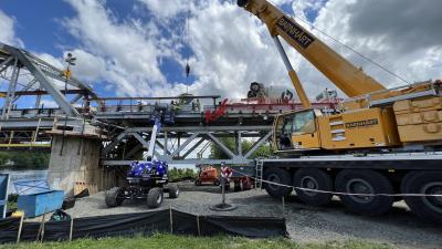
Millions of cubic yards of materials are needed to raise the 7-mi. portion of roadway. About 100 side dump and bell dump semis were used to haul in 2.6 million cu. yds. of borrowed embankment materials and another 1.4 million cu. yds. (1,070,379 cu m) of borrowed impervious clay core material. Another 300,000 cu. yds. (229,366 cu m) of waste excavation was removed from the site in order to improve the remaining soil. About 200,000 tons (181,437 t) of aggregate base course was placed, as well as about 130,000 tons (117,934 t) of sand drainage material and about 430,000 tons (390,089 t) of rip rap and bedding stone. All will be topped with about 20,000 tons (18,144 t) of asphalt paving.
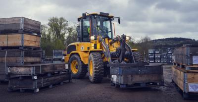
Twelve Caterpillar model 330 to 375 excavators were used to move the materials, along with eight Caterpillar D5 to D8 dozers, two Caterpillar 627 scrapers, and four Caterpillar 140 motorgraders. Five Dynapac and Caterpillar sheeps-foot and smooth-drum compactors were also needed.
Temporary steel sheet piling was set into place with a Manitowoc 10000 100-ton crane with an H & S 4400 vibratory hammer.
Numerous large earthwork projects in the Devils Lake are creating congested work conditions and “a shortage of trucks and qualified workers to fill everyone’s needs,” Lovin said. Other projects in the Devils Lake include several locations along Highway 19, which intersects with northern points of Devils Lake such as Six Mile Bay, Mauvis Coulee and Minnew. Flats, Creel Bay Crossing by the Devils Lake airport, US 2 east of Penn, Highway 20 at Spring Lake, the Devils Lake Dike and Grahams Island Road.
Once the highways have been raise and the embankment is complete an emergency outlet for Devils Lake will need to be constructed in order to create a permanent solution to the community’s flooding issues. Several locations for an outlet have been proposed but no decision has yet been made. CEG
Construction Equipment Guide
470 Maryland Drive
Fort Washington, PA 19034
800-523-2200
Construction Equipment Guide covers the nation with its four regional newspapers, offering construction and industry news and information along with new and used construction equipment for sale from dealers in your area. Now we extend those services and information to the internet. Making it as easy as possible to find the news and equipment that you need and want.
Contents Copyrighted 2024, by Construction Equipment Guide, which is a Registered Trademark, registered in the U.S. Patent Office. Registration number 0957323. All rights reserved, nothing may be reprinted or reproduced (including framing) in whole or part without written permission from the publisher. All editorial material, photographs, drawings, letters, and other material will be treated as unconditionally assigned for publication and copyright purposes and are subject to Construction Equipment Guide’s unrestricted right to edit and comment editorially. Contributor articles do not necessarily reflect the policy or opinions of this publication.
Read our privacy policy here.
Mastodon