


Our Main Office
Construction Equipment Guide
470 Maryland Drive
Fort Washington, PA 19034
800-523-2200
Tue November 21, 2006 - Southeast Edition
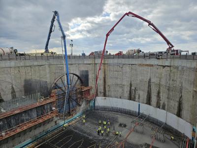
NEW ORLEANS (AP) _ A multi-billion dollar proposal state officials have drafted to protect New Orleans and other south Louisiana communities from hurricanes while rebuilding coastal wetlands would dramatically change the shape of the state’s coastline.
A draft unveiled this week represents the state’s first concrete statement on the array of massive engineering projects — such as levees, dikes and freshwater diversions — that officials believe are needed to save the state’s coastline and protect hundreds of thousands of South Louisiana residents from future storms.
State officials said the preliminary report is the result of more than a year of planning and discussions involving the Army Corps of Engineers, coastal wetlands scientists and experts, parish and civic leaders, stakeholders and residents of coastal areas.
The plan was shown Nov. 8 to the Louisiana Coastal Protection and Restoration Authority. The authority was asked to make suggestions for possible changes to the draft plan before it is presented to the public in a series of meetings in New Orleans and Houma on Nov. 29 and Lake Charles on Nov. 30. A final draft will be presented for approval to the Louisiana Legislature next spring, according to a state press release.
Lobbying efforts to get financial backing from Congress are expected to go on for years.
Among the highlights of the plan’s recommendations:
• A floodgate at the Rigolets, near Slidell, and a dike stretching southwest from there down the middle of Lake Borgne to Proctor’s Point in St. Bernard Parish would protect New Orleans and communities fronting Lake Pontchartrain from catastrophic storm surge.
• Plaquemines Parish would be divided into three levels of levee protection, with only the areas closest to New Orleans receiving “Category 5” protection.
• The Mississippi River-Gulf Outlet, the controversial 76-mi. shipping channel that connects New Orleans with the Gulf of Mexico would be closed. The channel is blamed by many St. Bernard Parish residents and some hurricane protection experts for amplifying Hurricane Katrina’s surge and hastening the loss of an estimated 27,000 acres of marshland that once shielded the metropolitan area’s eastern flank.
Those and other controversial proposals have been recommended before, but died in the face of opposition from interest groups, such as residents of lower Plaquemines or shipping interests that will be shut out of the MRGO.
After Katrina, the political landscape has shifted to give added weight to hurricane protection and coastal restoration, said King Milling, an authority member and chairman of the Governor’s Advisory Commission on Coastal Protection and Restoration, a separate body.
With its many and varied proposals, the state plan adopts a “multiple lines of defense” strategy proposed by John Lopez, a former Army Corps of Engineers official who now works for the Lake Pontchartrain Basin Foundation.
The plan begins at the coastline, recommending rebuilding of barrier islands and shorelines, and of ancient natural ridges that once marked the paths of old Mississippi River distributaries.
It recommends strengthening a variety of shorelines with rock or other materials, including the eastern edge of the Biloxi Marshes along Chandeleur Sound, the land bridge in eastern New Orleans between lakes Borgne and Pontchartrain and the land bridge between lakes Pontchartrain and Maurepas.
Also, the plan calls for using parts of the Gulf Intracoastal Waterway to move freshwater into wetlands, an antidote to saltwater erosion, as well as strengthening the banks of the waterway. Dozens of other freshwater diversions would be installed along the Mississippi and Atchafalaya rivers, with some freshwater reintroduced into Bayou Lafourche, and then into wetlands along its path.
A major obstacle to determining the worth of the state proposal is not knowing the level of protection that will be afforded by the new levees, said Mark Davis, executive director of the Coalition to Restore Coastal Louisiana. “That’s not on the map anywhere,” he said after the meeting. “I walked out of there with more questions than I had answers, but at least now we know what we’re questioning.”
State officials expressed similar frustration, blaming on the corps’ a delay in determining exactly what kind of storms represent the risk of a 100-year or 500-year hurricane. Corps officials at the meeting were unable to say when that information would be available.
Construction Equipment Guide
470 Maryland Drive
Fort Washington, PA 19034
800-523-2200
Construction Equipment Guide covers the nation with its four regional newspapers, offering construction and industry news and information along with new and used construction equipment for sale from dealers in your area. Now we extend those services and information to the internet. Making it as easy as possible to find the news and equipment that you need and want.
Contents Copyrighted 2024, by Construction Equipment Guide, which is a Registered Trademark, registered in the U.S. Patent Office. Registration number 0957323. All rights reserved, nothing may be reprinted or reproduced (including framing) in whole or part without written permission from the publisher. All editorial material, photographs, drawings, letters, and other material will be treated as unconditionally assigned for publication and copyright purposes and are subject to Construction Equipment Guide’s unrestricted right to edit and comment editorially. Contributor articles do not necessarily reflect the policy or opinions of this publication.
Read our privacy policy here.
Mastodon