


Our Main Office
Construction Equipment Guide
470 Maryland Drive
Fort Washington, PA 19034
800-523-2200
Fri January 07, 2011 - Southeast Edition
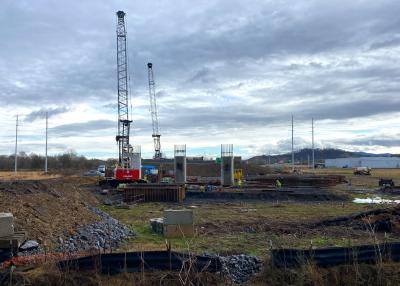
BENTON, Ark. (AP) Highway officials say one of the worst stretches of pavement on an interstate highway in Arkansas fully meets specifications, because those specifications called for substandard construction methods and materials, to test their effects.
The section of westbound lanes is roughly between mile markers 108 and 110, south of I-30’s intersection with U.S. 70, southwest of Benton and just north of Saline County’s border with Hot Spring County, is among the most dilapidated parts of the interstate system in the state.
The Arkansas Democrat-Gazette reported that a dozen 500-ft. (152 m) sections in that stretch were designed and built as part of a national pavement-testing program that the federal government began in the late 1980s.
Modern design calls for at least 12 in. (30.5 cm) of surface concrete. The test sections have thicknesses ranging from 8 in. to 11 in. (20 to 28 cm). The bases on which the surfaces rest also fall short of standards, so the pavement would break down.
“Several times we’ve gotten heat from the public,” said Alan Meadors, who heads the planning and research division at the Arkansas Highway and Transportation Department. “Enough to make you wonder if you need to have your head examined for putting in these sections that are designed to fail.”
The deterioration of the test surfaces gave highway-construction engineers markers to use when looking at stronger-built road surfaces that fail at a slower rate.
“It’s been very exciting for me to see in a short period of time what usually takes years,” Meadors said.
The I-30 site is one of more than 2,000 in the nation that have been part of the Long-Term Pavement Performance program, which federal highway officials bill as the most comprehensive pavement research program ever undertaken.
Rachel Keesee and Robin Belt, engineers from Austin, Texas, are performing the tests as part of a contract their employer, Fugro Consultants, has with the Federal Highway Administration. The two engineers are taking measurements and collecting other data that will be fed into local and national databases for research.
Keesee said she has been testing such sites in an 11-state region for 11 years and knows them so well they are “almost like friends.”
Among the observations Keesee and Belt will be making are the differences between the level of one slab and another, using an instrument called a falling-weight deflectometer. It is accurate to within a thousandth of a millimeter, Meadors said. Over time, each slab can rise or fall, creating an uneven surface that generates thumping as vehicles pass over it.
The program grew out of a 1984 report from the Transportation Research Board that recommended long-range field tests to systematically measure and record a “wide range of climate, soil, construction, maintenance and loading conditions.”
Construction Equipment Guide
470 Maryland Drive
Fort Washington, PA 19034
800-523-2200
Construction Equipment Guide covers the nation with its four regional newspapers, offering construction and industry news and information along with new and used construction equipment for sale from dealers in your area. Now we extend those services and information to the internet. Making it as easy as possible to find the news and equipment that you need and want.
Contents Copyrighted 2024, by Construction Equipment Guide, which is a Registered Trademark, registered in the U.S. Patent Office. Registration number 0957323. All rights reserved, nothing may be reprinted or reproduced (including framing) in whole or part without written permission from the publisher. All editorial material, photographs, drawings, letters, and other material will be treated as unconditionally assigned for publication and copyright purposes and are subject to Construction Equipment Guide’s unrestricted right to edit and comment editorially. Contributor articles do not necessarily reflect the policy or opinions of this publication.
Read our privacy policy here.
Mastodon