


Our Main Office
Construction Equipment Guide
470 Maryland Drive
Fort Washington, PA 19034
800-523-2200
Thu May 31, 2007 - Northeast Edition
Since the late 1960s, there has been talk about improving New York State’s Route 17 in the Village of Horseheads. Now, more than 40 years later, a $60 million project is not only giving Route 17 a major facelift, it is upgrading it to interstate status.
New York State Route 17 — also known as the Southern Tier Expressway — runs from Suffern, N.Y. (where it connects to New Jersey 17), to the Pennsylvania border in western New York. The entire highway is gradually being re-signed as Interstate 86 as part of an upgrade to the route, replacing at-grade intersections and bringing the road up to Interstate standards.
Currently, Route 17 is New York State’s longest highway. It stretches 397 mi. (639 km) and serves 11 New York counties: Allegany, Broome, Cattaragus, Chautauqua, Chemung, Delaware, Orange, Rockland, Steuben, Sullivan and Tioga. When it becomes fully transformed into Interstate 86, the title of longest New York State Route will be given to Route 5.
Highway History
The original NY 17 was a two-lane local route built in the late 1920s. Unlike today’s modern highway, it took a more southerly route from Corning to Olean (along what is now signed as NY 417). At its western terminus it veered northwest to the village of Westfield along Lake Erie (now parts of NY 394 and NY 430).
The explosive growth of the tourism industry in the Catskill Mountains region, which began in the 1930s and intensified after World War II, stretched the rural road to its limits. In response, New York state officials planned a four-lane replacement, the first free long-distance expressway in the state and one of the earliest in the United States.
It would replace intersections with well-placed access ramps, separate grades with flyovers and allow safe travel at up to 65 mi. per hour.
In 1998, NY 17 was designated a “high-priority” corridor by the U.S. federal government. That designation enabled the highway to receive Interstate designation and structural upgrades. In December 1999, the westernmost 185 mi. were re-signed Interstate 86. As of 2005, the Interstate designation was extended east to Route 14 in Horseheads. The remainder of NY 17 west of I-87 is slated to be signed I-86 in 2012 after the remaining at-grade sections are converted to limited access.
A Long Time Coming
Plans for change in Horseheads started in 1966, when the New York State Department of Transportation (DOT) conducted a formal scoping study. That is when it was determined that the reconstruction or realignment — or a combination — of Route 17 would be necessary to reduce the potential for accidents and to facilitate the statewide and regional mobility that would enhance the region’s economic viability.
After examining several alternatives, a design was chosen that would minimize negative impacts and improve safety and traffic flow. The chosen alternative emerged from a series of studies that examined the social, economic, and environmental impacts of different options.
The decision was made by local residents, government officials and business representatives. The group’s selection consisted of two one-way service roads, generally running between Center Street and South Main Street, along the north and south sides of a new expressway. It also included a westbound exit ramp at Grand Central Avenue.
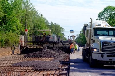
“Route 17 comes down through the village at three at-grade, traffic signal-controlled intersections,” explained Ron Majesky, DOT’s engineer-in-charge of the project. “There has been a history of congestion and serious accidents [in that area]. Consequently, the main thrust of this project is to eliminate those intersections. The new highway will go overhead through the village. It is built up on retaining walls — reinforced, earth-type walls — mechanically stabilized earth systems, pre-cast concrete units that form a vertical retaining wall and are held back by soil pressure.”
Project design specifics included:
• Constructing an elevated expressway from the Norfolk Southern Railroad near the Center Street Elementary School to the crossing of Newton Creek west of South Main Street.
• Constructing bridges at Center Street, Grand Central Avenue and South Main Street to allow local traffic to travel north and south through the project area.
• Accommodating local traffic on one-way service roads along the north and south sides of the elevated expressway. A westbound service road would be constructed along the north side of the expressway and an eastbound service road constructed along the expressway’s south side.
• Creating access to the village from the expressway via an eastbound exit ramp near Route 14 or from westbound exit ramps at Grand Central Avenue or at the Route 13 Interchange.
• Creating expressway access from the village via an eastbound entrance ramp at South Main Street or a westbound entrance ramp at Center Street.
• Reconstructing the Route 13 Interchange also would be included. New bridges would be provided that would carry Route 13 over Route 17 along with a new bridge that would carry an exit ramp from Route 17 westbound to Horseheads over Route 13.
Federal regulations require DOT to assess the effectiveness of noise barriers wherever noise levels exceed 67 decibels. The ambient noise levels in the project area exceeded 65 decibels, which is the accepted noise level at which most people can carry on a conversation without raising or straining their voices.
Based on DOT’s findings, noise barriers were placed on the north side of Route 17 between South Main Street and the Norfolk-Southern Railroad Crossing, a mainly residential area. Barriers also were placed along Route 17 near the Thorne Street properties.
The prime contractor on the project is Lane Construction out of Meridian, Conn.
Multi-Phase Construction
The Route 17 project was divided into three phases.
• Phase I — Spring 2004. During this phase Route 17 traffic was maintained at its current location while the westbound service roads and ramp system were constructed and the Route 13 Interchange was reconstructed. A detour of eastbound Route 17 traffic wanting to go north on Route 13 was required for the Route 13 bridge to be constructed over Route 17.
While the Route 13 Interchange was being reconstructed, a temporary signal was installed at the Route 17 westbound intersection with temporary Route 13.
The temporary intersection allowed access from Route 13 southbound to Route 17 in both the eastbound and westbound directions. It also provided access for Route 17 westbound traffic to Route 13 northbound.
• Phase II — Spring 2005. Westbound Route 17 traffic was shifted to the newly constructed westbound service road. Eastbound traffic was shifted to the old westbound lanes while the eastbound service road and ramp system were constructed.
• Phase III — Spring 2006. Westbound traffic on Route 17 remained on the new westbound service road and eastbound Route 17 traffic was shifted to the newly constructed eastbound service road system while the new Route 17 lanes and the associated bridge overpasses were constructed.
In addition, new water mains, storm drainage and sanitary sewer were installed on the north side of the highway.
“A small, anti-icing system also was added on one particular ramp that is vulnerable to icing. The system, which sprays chemicals on the highway, is automated and based on pavement and air temperatures and humidity. The chemicals are pumped through tubing,” said Majesky.
With all that work, what presented the biggest challenge? “Traffic. It’s always traffic,” said Majesky. “Over 22,000 cars come through here daily so there was no detouring. We had to keep [Route] 17 running through the project every day. There was no night work because of the residential areas.”
Work on local streets and minor work on Route 17 will complete the project in summer 2007.
An Eye for the Aesthetic
As part of the Route 17 improvements through Horseheads, the DOT formed an Aesthetics Task Force (ATF). Its goal was to promote discussion and provide input and feedback regarding aesthetic features that could be incorporated into the project design.
The ATF was comprised of members from Horseheads, the Horseheads Merchants Association, the Chemung County Chamber of Commerce, the Horseheads School District and village residents.
The task force concentrated on prioritizing locations where aesthetic enhancements would best suit the community. Consideration was given to retaining and noise walls, Linear Park, which features walkways, benches, lights and landscaping, and a village entrance signing.
One such aesthetic enhancement involves 13 brick sculptures, which will be laid into each wing wall of the local bridges. Sculpted by a local artisan, each brick is cut and fired and comes out as individual pieces. The sculptor then puts them together. One sculpture already is in place. Some of the precast on the walls also will have architectural treatments. Rather than plain concrete there are architectural form liner finishes.
“While the area itself isn’t historic we are trying to incorporate some of the architectural things that were in the village, brick being one of them. The Horseheads Brick Company used to be located here,” said Majesky.
“The architectural treatments — the sculptures — add a uniqueness to the job because it’s in an urban setting. That’s not something you generally see in the middle of the country,” he added. CEG
Construction Equipment Guide
470 Maryland Drive
Fort Washington, PA 19034
800-523-2200
Construction Equipment Guide covers the nation with its four regional newspapers, offering construction and industry news and information along with new and used construction equipment for sale from dealers in your area. Now we extend those services and information to the internet. Making it as easy as possible to find the news and equipment that you need and want.
Contents Copyrighted 2024, by Construction Equipment Guide, which is a Registered Trademark, registered in the U.S. Patent Office. Registration number 0957323. All rights reserved, nothing may be reprinted or reproduced (including framing) in whole or part without written permission from the publisher. All editorial material, photographs, drawings, letters, and other material will be treated as unconditionally assigned for publication and copyright purposes and are subject to Construction Equipment Guide’s unrestricted right to edit and comment editorially. Contributor articles do not necessarily reflect the policy or opinions of this publication.
Read our privacy policy here.
Mastodon