


Our Main Office
Construction Equipment Guide
470 Maryland Drive
Fort Washington, PA 19034
800-523-2200
Mon June 05, 2006 - Southeast Edition
NEW ORLEANS (AP) In just eight months, the U.S. Army Corps of Engineers has done years of work on the Katrina-battered ramparts around New Orleans.
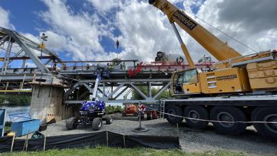
The Corps has repaired 169 mi. (272 km) of damaged levee. Replaced long stretches of inadequate concrete floodwall with a much sturdier design. Installed 70-ton (64 t) gates at the mouths of ruptured drainage canals.
But it isn’t good enough.
Even the man who has led the monumental effort to bring the Big Easy’s hurricane protection infrastructure back to pre-Katrina standards said so.
The defenses are “better, stronger and more resilient” than ever, said Col. Lewis Setliff. “But I’m only fixing about 60 percent of the system.”
By and large, Setliff is on schedule to fulfill his mission of restoring them by June 1, the beginning of the 2006 hurricane season. But there are still many weak spots in the barricades that protect New Orleans from the sea. As Hurricane Katrina dramatically illustrated, one vulnerable spot is all it takes to unleash a disaster.
Experts fear last year’s catastrophe will repeat itself unless the federal government embarks on a monumental effort to keep New Orleans dry.
Engineers and scientists have called for an improved flood control system that would cost billions of dollars and take years to construct — but that’s not all. They propose an even costlier and decades-long effort to restore the dying coastal wetlands that once buffered New Orleans from violent storms.
“Louisiana is an engineered landscape. All we’ve got to do is engineer it a little smarter,” said Ivor van Heerden, assistant director of Louisiana State University’s Hurricane Center and an inveterate critic of the Corps of Engineers.
Such an effort would require a commitment by the federal government of up to 10 times what it currently plans to spend on flood control in and around New Orleans.
The Bush administration has proposed spending $2.5 billion to strengthen the New Orleans levee system to “100-year protection,” meaning that there would be a 1 percent chance of the structures being overtopped in any single year. It would take until 2010 to construct and bring the total cost of levee repair and improvement since Hurricane Katrina to approximately $6 billion.
Approximately $1 billion of the extra $2.5 billion would be used to raise some levees by as much as 7 ft. The remainder would go toward replacing miles of concrete flood barrier known as I-wall, for its plain vertical cross-section, with T-wall, which rests on an erosion-resistant horizontal base and is better anchored in the ground.
The plan would protect 98 percent of the population. But it would leave out a narrow strip of land along the Mississippi River south of the city. That area, lower Plaquemines Parish, is home to 14,000 people but would cost more than half as much as all of the other projected work to bring up to 100-year protection.
Most engineers are satisfied that the breaches along the London Avenue and 17th Street drainage canals — the holes that sent water pouring into the heart of New Orleans — have been fixed, and that there will be no reprise.
The Corps is installing massive gates at the mouths of the canals that will swing shut in the event of a major storm, isolating them from the advancing waters of Lake Pontchartrain.
But the defenses along the city’s margins inspire a lot less confidence.
“This is the protection for one of our premier cities,” said van Heerden.
He stood beside a cracked concrete rampart at the western fringe of New Orleans, on a narrow strip of land between the wall and a typical expanse of Louisiana wetland. The wall was too high to see over, but from a boat out in the scrubby marsh one could see the rooftops of a tidy subdivision on the other side.
“You can see the bulge here. You can see how it’s cracking and opening as the section is sinking,” van Heerden said.
This section of levee was not subjected to particularly intense conditions during Hurricane Katrina. But in another big storm, it and many other weak points might succumb. It’s those places the people of New Orleans should worry about now, van Heerden said.
“There are still places where the wall is just sheet pile,” he said, referring to the steel curtains that are driven into the crowns of levees as a skeleton for concrete floodwalls.
During Hurricane Katrina the levees protecting St. Bernard Parish, the Lower Ninth Ward and New Orleans East — all poor to middle-class communities — saw their levees fail not just in one or two places, but wholesale. Water came over — and possibly through — the earthen structures in massive torrents, toppling concrete floodwalls and carrying away entire houses. Waves smashed against the levees on their seaward side, tearing them down as if they were sandcastles being devoured by an advancing tide. Water pouring over the tops of concrete floodwalls cascaded down and scoured away the earth behind them, weakening their foundations.
After the storm, the Corps of Engineers replaced the damaged sections of I-wall with T-wall. While the repaired floodwalls aren’t significantly higher than the ones they replaced, at least they are more resistant to complete collapse.
In places like St. Bernard Parish, a suburb southeast of New Orleans, the Corps a;sp has rebuilt levees with clay-rich dirt imported from Mississippi rather than the more easily eroded local soils.
“The materials that they’re putting in there now are vastly superior to what was there before Hurricane Katrina,” said Robert Bea, a civil engineering professor of the University of California in Berkeley who is part of a federally-funded team monitoring the rebuilding effort.
But he and his colleagues worry that better materials won’t be good enough. They are urging the Corps to “armor” the levees by covering their earthen slopes with a plastic barrier or stone pavement to prevent erosion. The Bush proposal includes “selective” armoring for the most vulnerable sections, but stops short of reinforcing larger sections of levee.
However they are rebuilt, the levees will not solve a central, manmade problem: That all of southeast Louisiana has been profoundly altered by human activity, and that those changes have left its inhabitants more vulnerable to hurricanes.
The Mississippi River once overflowed its banks every spring, spreading a fine silt through the marshes and swamps of southern Louisiana. Practically all of the state south of Interstate 10 wouldn’t exist if not for the sediments that have been dropped by the Mississippi over the millennia.
But now that precious Mississippi mud goes right into the Gulf of Mexico. High levees all up and down the river prevent the annual spring flood, so the silt goes all the way down the river and out to sea.
Meanwhile the sediments that are southern Louisiana compact under their own weight at the same time that sea level gradually rises, due to a combination of natural and human-induced global warming.
“If the ecosystem is going to survive it’s got to build up,” said Denise Reed, a coastal geomorphologist of the University of New Orleans.
It is a game of inches, and Louisiana’s wetlands are losing. Since the 1930s, 4 percent of the state — 1,900 sq. mi. (4,920 sq km) — has disappeared beneath the Gulf of Mexico.
Wetlands are important for hurricane protection because they act like “horizontal levees,” said Donald F. Boesch, a professor of marine science of the University of Maryland. When a storm surge encounters a healthy wetland, the tangle of vegetation absorbs some of the water’s impact. As a general rule of thumb, every 3 to 4 mi. of wetland that a storm surge crosses reduces its elevation by 1 ft.
Some of Louisiana’s lost wetlands could be rebuilt, or at least the continuing decline could be slowed. There are already gates in two spots on the Mississippi — and there could be more — that allow water to spill out through the levees into adjacent marshes, replenishing them with the sediments they need to thrive. Existing wetlands could be protected from erosion by shoreline barriers, offshore barrier islands could be reconstructed with sand dredged out of the Gulf of Mexico and vegetation could be planted in vulnerable areas.
“If you can restore the wetlands you don’t have to invest as much in the levees,” said Brig. Gen. Robert Crear, commander of the Corps’ Mississippi Valley Division.
Still, this does not come cheap. By one estimate, it would cost $14 billion over the next 30 years. CEG
Construction Equipment Guide
470 Maryland Drive
Fort Washington, PA 19034
800-523-2200
Construction Equipment Guide covers the nation with its four regional newspapers, offering construction and industry news and information along with new and used construction equipment for sale from dealers in your area. Now we extend those services and information to the internet. Making it as easy as possible to find the news and equipment that you need and want.
Contents Copyrighted 2024, by Construction Equipment Guide, which is a Registered Trademark, registered in the U.S. Patent Office. Registration number 0957323. All rights reserved, nothing may be reprinted or reproduced (including framing) in whole or part without written permission from the publisher. All editorial material, photographs, drawings, letters, and other material will be treated as unconditionally assigned for publication and copyright purposes and are subject to Construction Equipment Guide’s unrestricted right to edit and comment editorially. Contributor articles do not necessarily reflect the policy or opinions of this publication.
Read our privacy policy here.
Mastodon