


Our Main Office
Construction Equipment Guide
470 Maryland Drive
Fort Washington, PA 19034
800-523-2200
Fri January 20, 2006 - Southeast Edition
When Ponce de Leon discovered the Florida Keys in 1513, he thought the islands were nothing but deserted mosquito-infested lands that failed to produce the Fountain of Youth.
While Florida didn’t offer the miracle of eternal youth, it now boasts a miracle of engineering, the Overseas Highway.
The scenic roadway connects the islands with a series of 42 bridges that cross over portions of the Atlantic Ocean, Florida Bay and the Gulf of Mexico.
Throughout much of the early 20th Century, this flourishing vacation spot was not so picturesque and the islands were not as easily navigable as they are presently.
Beneath the blue skies and wispy white clouds loomed expansive waterways and severe winds. In the early 1900s, reliable and safe transportation from one island to another in the Florida Keys was nowhere to be found.
For centuries, the only way to reach the Florida Keys had been by ferry, which proved to be highly inadequate. It had a very limited capacity and traveled through the water at a snail’s pace.
In addition, low tides and shallow water often caused long delays for travelers. Frustrated by the ferry’s inconvenience and unreliability, plans were mapped out to construct a string of bridges to gap the waterways for vehicular traffic.
It was not until 1912 that an alternate mode of transportation became available to Keys’ residents and travelers.
During that year, Henry Flagler’s $50-million Florida East Coast Railway opened. Excited by the prospect of an easier commute from island to island, hundreds of thousands of tourists flocked to the railroad.
Travel did not come cheap, however. One round-trip ticket cost approximately $425, which is equivalent to $8,541 today.
Bridge Over Troubled Waters
On Sept. 2, 1935, a hurricane ripped through the Keys.
As the waves pounded the vulnerable islets, train cars were knocked about and thrashed off the rail line. One ferryboat also was lost at sea.
With 200- to 250-knot winds and 18-ft. tidal surges, the hurricane left at least 500 people dead.
The storm also destroyed major portions of the tracks as 40 mi. (64 km) of causeways and rail beds were washed out, leaving the Keys in a state of despair.
Surprisingly, the concrete railroad bridges did not waver under the storm’s immense force, although only a few of the original piers still stand today.
Repairing the Damage
After assessing the damage and seeking an alternative to the inadequate rail system, Florida officials turned the railroad into an extension of U.S. 1, a two-lane highway that stretches from Florida City to Key West.
Large portions of the highway were built on the former alignment of the Florida East Coast Railway. The original construction used many of the bridges from the former railroad, including truss bridges, where the railway was built on top of the trusses.
Most of the older bridges that were built for the railroad have been replaced and modernized to accommodate more than two lanes of traffic.
The public works administration approved a loan to the overseas Railroad and Toll Bridge District for $3.6 million. In turn, the district issued revenue bonds to be paid back by tolls.
Tolls cost $1 for each car, including the driver, and 25 cents for each additional passenger.
Rumors of misuse of toll revenue spread like wildfire throughout the Keys. Investigations were conducted after the Florida Keys Weekly News reported 15,254 vehicles had paid more than $29,000 in tolls in 1947.
Road tolls were eventually lifted in 1954 after much controversy and pressure from the locals.
Linking the Keys
B. M. Duncan was chosen as the district’s general manager and chief engineer to convert the railroad bridges into a modern highway system.
The state Road Department constructed concrete bridges on timber piles above the Tavernier, Snake and Whale Harbor channels, while various contractors finished the Upper Keys roadwork.
The Overseas Highway opened to the public in 1938, using the old Card Sound and south Big Pine Key routes. Although the highway had opened on March 29, 1938, the official opening ceremony did not take place until July 4.
Modifications All Around
Highway conversion created an engineering problem for contractors on the Bahia Honda Bridge. Construction was a tricky task because the top of the camelback trestle rose 65 ft. (19.8 m) in the air.
The final solution was to build a concrete road slab on top of the trusses and graduate the climb and descent for automobiles. The Bahia Honda Bridge was the first bridge to be bypassed when a new four-lane bridge was constructed in 1972.
Steel beams were laid across the more conventional bridges and a layer of reinforced concrete encased the beams. Each bridge was given a 9-in. (22.9 cm) high and 20-in (50.8 cm) wide curb. The road itself measured 20 ft. (6.1 m) across, curb to curb.
To reduce travel time and eliminate narrow, weak wooden bridges in the Upper Keys, the Card Sound SR4 loop was bypassed using the abandoned Florida East Coast Railway right of way.
The new highway was built alongside the freshwater pipeline that was authorized in 1941.
In the Lower Keys, south Big Pine 4A route via the Pirates Cove was bypassed for the same reasons and also mostly used the original rail route. These two bypasses cut 17 mi. (27.4 km) of travel time.
From Maine to Key West
Another modification ceremony took place in 1944, where Gov. Spessard L. Holland dedicated the Overseas Highway to “the greatness of the Keys.”
The official opening of the Overseas Highway was particularly important because the completion of the road allowed travelers to drive down the entire east coast from Fort Kent, ME, to Key West, FL, on U.S. 1 for the first time.
Currently, the Overseas Highway, along with its 42 bridges, spans across 113 mi. (182 km).
The modern Overseas Highway is the result of major changes that have been made throughout the years.
Of the 42 bridges, three have been named national historical sites on the National Register of Historical Places: Seven Mile Bridge, Bahia Honda and Long Key.
Donna Causes Damage
Although the Keys recently managed to escape the wrath of Hurricane Katrina, the islets were not so fortunate 45 years ago.
“The last serious breach by a hurricane was caused by Donna in 1960,” said Jerry Wilkinson, president of the Historical Preservation Society of the Upper Keys.
On Sept. 8, 1960, dreaded warning flags — red with black squares — served as a caution as they were erected in place along the Keys.
The Weather Bureau instilled fear into Keys’ citizens, warning that the approaching hurricane was carrying the same amount of energy as a hydrogen bomb exploding approximately every eight minutes.
Many Keys residents took heed of the warning, packed up their belongings and headed north to safety.
Winds howled at speeds of 150 mph and a 13-ft. tidal surge pounded the islets as the Category 4 hurricane barreled into the Keys and tore through everything in its path.
One of the most crippling effects of the hurricane in the Keys was the damage sustained to the Tea Table Bridge, which is located just south of Upper Matecumbe Key. The bridge was completely washed out as a result of the surmounting floodwaters and halted access between the Middle and Lower Keys.
In response, an emergency bypass route was installed at the Tea Table Relief Bridge site to re-establish traveling between the Middle and Lower Keys.
Before the Tea Table Bridge could be rebuilt, the Bailey Bridge was erected to serve as a temporary link. The Bailey Bridge was used to cover the gap only until repairs were made over the next several years.
A Long Time Coming
After years of wear and tear, the antiquated Seven Mile Bridge needed to be restructured and updated for modern use.
Figg Engineering Group accepted the challenge to create a new design and Misener Marine Construction signed on as the project’s contractor.
Construction began in 1979 and the entire bridge was constructed six months ahead of schedule. Its design cut $7 million from the project’s estimate.
Seven Mile Bridge was granted the Federal Highway Administration’s (FHWA) Excellence in Highway Design Exceptional Award for cost-saving innovations.
Upon its completion in 1982, the rebuilt Seven Mile Bridge officially became the longest continuous concrete segmental bridge in the world. It measures 35,867 ft. (10,932 m) long.
The new bridge used a precast, post-tensioned box girder superstructure and hollow precast segmental piers, which increased the speed of its erection.
This marked the first time that precast, match-cast box tiers were used in the United States and assembled with vertical post-tensioning.
Work also included the installation of 36-in. (91.4 cm) and 48-in. (122 cm) diameter drilled shaft foundations.
The new Seven Mile Bridge’s 65-ft. (20 m) high arch allows clearance for boats to pass through uninterrupted. Likewise, drivers can pass over the bridge without delay, as there is no need for bridge openings.
Although the old Seven Mile Bridge is closed to traffic, it is currently be used as a fishing pier.
Recent Repairs
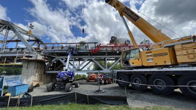
According to Wilkinson, the bridges on the Overseas Highway are under a constant state of repair.
“Most of the current repairs are corrosion protection related,” said Frank Guyamier, a Florida Department of Transportation (FDOT) structure and facilities engineer.
“FDOT is currently seeking additional funding from their central office to keep up on these repairs,” Guyamier said. “The only repairs that have been performed [recently] were inside the segmental post-tension bridges.”
Due to increased Homeland Security, Guyamier was unable to disclose the details regarding the bridge repairs because the plans show reinforcing details of the structures.
Approximately 20 years ago, the Tavernier Creek Bridge in the Upper Keys was widened to four lanes to coincide with the four-lane U.S. 1.
In the early 1990s, a project raised the Marvin Adams Waterway Bridge in the Upper Keys so it was no longer higher on one side.
Within the next year, construction will begin to eliminate the Jewfish Creek drawbridge at Key Largo. The drawbridge will be replaced with a new bridge that will span 7,500 ft. (2,290 m) across the creek.
The new Jewfish Creek Bridge also will feature a 65-ft. (20 m) high arched span to reduce traffic stoppages.
In the next few years, the C-111 canal bridge, which is adjacent to Everglades National Park, will be rebuilt to accommodate the three-lane road connected to it.
Most recently, Hurricane Katrina washed seaweed across the Lower Matecumbe Key section of the Overseas Highway, but that is a normal occurrence, said Wilkinson.
“One day they will fix that, but it is in the Upper Keys. Nothing gets much attention until it affects Key West traffic,” he said.
The Upper Keys are last for reconstruction because money is spent from Key West northward, added Wilkinson. CEG
Construction Equipment Guide
470 Maryland Drive
Fort Washington, PA 19034
800-523-2200
Construction Equipment Guide covers the nation with its four regional newspapers, offering construction and industry news and information along with new and used construction equipment for sale from dealers in your area. Now we extend those services and information to the internet. Making it as easy as possible to find the news and equipment that you need and want.
Contents Copyrighted 2024, by Construction Equipment Guide, which is a Registered Trademark, registered in the U.S. Patent Office. Registration number 0957323. All rights reserved, nothing may be reprinted or reproduced (including framing) in whole or part without written permission from the publisher. All editorial material, photographs, drawings, letters, and other material will be treated as unconditionally assigned for publication and copyright purposes and are subject to Construction Equipment Guide’s unrestricted right to edit and comment editorially. Contributor articles do not necessarily reflect the policy or opinions of this publication.
Read our privacy policy here.
Mastodon