


Our Main Office
Construction Equipment Guide
470 Maryland Drive
Fort Washington, PA 19034
800-523-2200
Thu October 04, 2007 - Northeast Edition
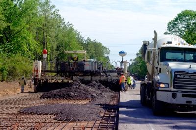
On the Route 219 south project in Region 5 of the New York State Department of Transportation ancient history is meeting up with cutting edge technology.
The project involving U.S. Route 219 south has begun. Work on the first northern sections of the freeway beginning at Route 39 in Springville (Erie County) is under way, with a cost of $85 million. The next section (3.5-mi. [5.6 km]) ending near Snake Run Road in Ashford Hollow (Cattaraugus County), at a cost of $57 million, is scheduled to be let later this year.
The NYSDOT said it is committed to working cooperatively with the Seneca Nation of Indians to reach an agreement on the use of their land for the final section of the freeway leading to the completion of the entire 28-mi. (45 km) project. As yet the agreement between the NYSDOT and the Seneca Nation of Indians has not been secured to construct the southern most portion of the freeway that will link the project to I-86.
Currently under way is the 4-mi. (6.4 km) portion, a three-year project scheduled to be completed in September 2009.
Improving Trade Corridors Heading North and South
Susan Surdej, regional public information officer of NYSDOT Region 5, and an engineer, explained the economic impact of the 219 project.
“We are trying to ’first step’ many projects designed to keep expanding the expressways to support trade corridors,” she said.
“Old Route 219 actually does continue all the way south to another major road — Interstate 86, but when you get to Route 39, travel narrows from two expressway lanes in each direction to one travel lane in each direction, through small communities at 30 and 40 miles per hour.”
Of course, old Route 39 will continue to service local traffic in those communities.
While the new road will cross ancient Native American land rich with relics, the road itself will use some highly technical engineering to get the job done. The road portions of the project — the jewels of which are 11 separate bridges — are being accomplished using stakeless survey methods.
Stakeless survey is just one of the unique features of this project. Flagless or stakeless survey is driven by Global Positioning Systems (or GPS). Still relatively new in road construction in upstate New York, the flagless survey has gained real acceptance in the past five years or so, in part because fewer people are needed to accomplish the task, keeping costs down.
As John Wind, DOT construction supervisor on the project, explained, DOT specified in the original contract that his department would allow flagless survey methods, and would provide the data for it, if used. In the 219 project, the roadway portions will use the flagless survey and portions of the bridges.
“When it comes to actually setting grades for concrete pour, that needs to be done using conventional methods for the degree of accuracy required,” Wind said.
In a stakeless survey, Wind explained, survey data are downloaded directly into the earth moving machinery — often a dozer. Usually the first work is rough grading. Then when the site is ready for fine grading, the blade actually adjusts itself using the electronic data received. One reason that fewer people are needed is that when staking a survey, “you are constantly restaking the job.”
Eleven Bridges — Two of Them Unique
Engineers don’t often sound like poets, but Wind’s descriptions of the “aesthetically pleasing, pretty cool-looking, soaring, sweeping airy structures” that will span Zoar Valley and the Cattaraugus Creek have captured his imagination.
“The total span of these is 725 feet, and the main span of the arch is 450 feet. We’ve just completed the access road, so the bridge work — 225 feet over the gorge in one instance — will begin very soon.”
Borrowing a crowd-pleasing idea from the Hoover Dam bypass in Nevada, engineers designed the two new open spandrel steel arches to have a live camera that will take still images every 15 minutes and be available to anyone with Internet access, 24/7. This may be the first use of live cam on bridges in New York State.
Gaining Acceptance From the Seneca Nation
NYSDOT is working with the Seneca Nation of Indians to reach an agreement on the use of their land for the final section of the freeway leading to the completion of the entire 28-mi. project.
For example, in preparation for the current phase of the project, extensive archaeological surveys have been done in areas where the contractor needs to go in the vicinity for more dirt, or what’s called a “borrow job.”
For the most part, with the exception of plowing, the sites have remained undisturbed. Surveys, largely done by the Department of Anthropology, State University of New York at Buffalo, addressed data recovery for three archaeological sites situated within the project area limits. These include the prehistoric sites and the historic Blackmar-Eaton site (a tenant farm dwelling site).
The Seneca Nation provided observers to be present during fieldwork because all sites have the potential to yield important information on either the prehistory or history of southwestern New York.
A total of 8,790 artifacts were recovered during the phase 2 site examination. Spatial analysis was conducted with the aid of the Surfer 7.0 software package — a continuous surface generator used to interpolate artifact densities across the site and to help visualize these densities on the site map as contours, giving one a picture of prehistorical human life in these parts.
In DOT terms, prehistoric refers to artifacts and sites formed before European settlers came to the Americas. Historic refers to artifacts and sites that were formed because of European settlement.
So far prehistoric features have been in the form of burnt flakes that firmly date the charred material to the Meadowland Phase of the Early Woodland period.
While there are no settlement pattern models for western New York that focus specifically on Late Archaic (circa 4200-4800) sites in the Allegany Plateau uplands, the site was probably associated with hunter-gatherer subsistence lives. Such sites often occur where deer congregate in winter and on drier soils preferred by nut trees, which fed both the natives and the game animals they hunted by large creeks or streams.
In the Blackmar-Eaton site (circa 1838-1900), where settlers lived in the 19th and early 20th centuries, the categories for objects found gives some idea of the scope of the recovery: food-related, food remains, architectural, hygiene/medicinal, household furnishing, clothing, personal/amusement, lighting/electrical, tools/arms, smoking, miscellaneous modern, transportation/mechanical, energy and non-food faunal.
The New Route 219 Expressway Follows History’s Path
History records that this particular part of upstate New York, near the present day towns of Concord, Collins, North Collins and Sardinia, was formally organized as the town of Concord in 1812. Growth was slow because of the availability of better farmlands elsewhere, limitations on the types of farming, and the lack of transportation.
The earliest road in Concord was the Genesee Road or Cattaraugus Road that ran between the eastern border of the Holland Land Company purchase area, running west through Wyoming County, Sardinia, Concord, North Collings, and with an ending point near Lawton in the town of Collins.
Other early highways include the State Road, built in 1810 from Buffalo to Olean; and Townsend Road between Springville and Boston over Townsend Hill. During the 1820s, the first direct route between Springville and Morton’s Corners (NY Route 39) was built. During the following decade a road was constructed where the present day Sharp Road now stands. In 1852, local roads improved somewhat with a plank road constructed to Hamburg along the Eighteen-Mile Creek valley where it connected with another plank road that ran to Buffalo.
What those early pioneer road engineers would make of bulldozer blades that adjust automatically in response to data generated by satellites is anybody’s guess. CEG
Construction Equipment Guide
470 Maryland Drive
Fort Washington, PA 19034
800-523-2200
Construction Equipment Guide covers the nation with its four regional newspapers, offering construction and industry news and information along with new and used construction equipment for sale from dealers in your area. Now we extend those services and information to the internet. Making it as easy as possible to find the news and equipment that you need and want.
Contents Copyrighted 2024, by Construction Equipment Guide, which is a Registered Trademark, registered in the U.S. Patent Office. Registration number 0957323. All rights reserved, nothing may be reprinted or reproduced (including framing) in whole or part without written permission from the publisher. All editorial material, photographs, drawings, letters, and other material will be treated as unconditionally assigned for publication and copyright purposes and are subject to Construction Equipment Guide’s unrestricted right to edit and comment editorially. Contributor articles do not necessarily reflect the policy or opinions of this publication.
Read our privacy policy here.
Mastodon