


Our Main Office
Construction Equipment Guide
470 Maryland Drive
Fort Washington, PA 19034
800-523-2200
Fri March 31, 2006 - Southeast Edition
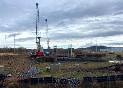
The proposed location of a new beltway in Tennessee has been greatly impacted by the presence of numerous caves in the area, making additional surveying and mapping services necessary.
The Knoxville Parkway (Interstate 475) would connect Interstate 75 in Loudon and Anderson County, TN. The divided highway would include a minimum of two 12-ft. traffic lanes in each direction.
The Tennessee Department of Transportation (TDOT) originally began surveying for the proposed I-475 in 2004. The caves were discovered during environmental and archeological investigations.
Engineering firm Vaughn & Melton (TN) Inc. of Knoxville was selected to provide surveying and mapping services. Its contract called for it to locate 24 caves relative to the proposed corridor, which was 1,000 ft. wide. In addition, the firm was to survey 10 caves and provide three-dimensional computer models of the four most significant caves.
“The state geotechnical man for this TDOT region in this area is an avid caver,” explained Bill Davis, survey coordinator of Vaughn & Melton. “He was trying to protect some of the resources that are in there, and some of the formations. He got together with some of the people at the state, and they knew that there were a lot of caves in the area of this proposed highway.”
The firm has a two-year, $289,400 survey contract agreement with TDOT.
“I was in charge of the survey coming together,” Davis said. “This included the team for the survey, processing the data, and all of the coordination with state agencies, property owners and other consultants who are doing design along the highway.”
Davis noted that caves need to remain intact.
“If there’s water running through them, and you block one up, that water’s gotta go somewhere, and it’ll come out somewhere, and it may not be where you want it to,” he explained. “If you build over one, even though you have enough depth, there’s the possibility of it all eroding.
“It affects the process of design in that it’s not the best situation to build over one. You need to avoid these caverns — anything that’s of any size — because caves are very active. You don’t want storm water run-off from your highway going directly into these things. You’ve got to change it around somehow — otherwise it just makes the caves bigger and quicker, and your highway would fall in.”
When he was in high school, Davis had some experience with caving, but had never worked on a project that involved caves during approximately 20 years of working for Vaughn & Melton. However, he was excited to learn about the project, and was “quite looking forward to it.”
The firm subcontracted AMEC of Nashville and A.G.E. Design Inc., of Coeur D’Alene, ID, to serve as its safety and expert team. The team was headed by Dominic Amari, a professional geologist and caver.
“They provided the safety team and the expert climbing team for the vertical pits that are in the caves,” Davis said. “We didn’t have the ability to climb up and down ropes at that time. Since they were expert climbers, also, and geologists, they were able to get us to everywhere and to map those caves in such a way that it was tied to the State Plane Coordinate System. The highway is also designed on the State Plane Coordinate System, so if you put these in a 3-D model with the design, you could tell exactly if you were going to run into a cave or not, or even get close to it. And that prevented any damage and safety issues with equipment operators during construction.”
Davis explained that three-dimensional computer models were made within the state’s software program that it uses for highway design. This was necessary for five caves. He noted that two different types of techniques for surveying were used.
“One was a conventional above-ground survey with survey instruments,” he said. “We had a prismless gun — it uses a laser and measures the distance without having to have something there to reflect back. We would literally record thousands of shots, and one of the caves was huge — it was 90-feet high ceilings and 50 feet wide. We just covered it up with located points, and then we imported all of those into the computer, straight from the data collector, and my tech would build the 3-D models from that.”
Where the passages were too small for conventional instruments to fit, the team located a point with the instrument close to the entrance, then worked from it with hand instruments.
“We used a compass for direction, a fiberglass tape for distance, and an inclinometer that measured degrees of slope,” Davis said. “With that degree of slope, that allowed you to carry elevations down as you went, and you knew how deep you were, and how close to the ground you were.”
Davis explained that their first experience with working totally in the dark with nothing but a flashlight proved to be quite challenging.
“We only had a single helmet light, and a little hand-held light, and it wasn’t enough,” he explained. “We finally adapted, but working in the dark was very time-consuming at first. We started with one of the hardest caves to do because we knew it would have every situation that we would run into in the others. The biggest rooms were the hardest ones to do. You’d think they’d be the easiest, but they were very hard.”
Another problem for the crew was learning how to keep their hands, instruments, and field book clean in the muddy caves. They learned to wear big, heavy gloves, and when they were ready to write, they put their hands palm-down in the mud, then slid their hands out of the gloves, which would stick to the mud. Then they could use their instruments with their clean hands.
There also were safety concerns, including hypothermia. For example, Davis noted that some water passages were deep enough that they had to swim through them. However, safety concerns were handled by the expert caving crew, which included a surface man that the team checked in with at regular intervals.
“We had certain time limits to get back and talk to him,” Davis explained. “Otherwise, he’d be calling in the helicopters and the rescue squad.”
Davis noted that new caves were continually found throughout the project, which began in March 2004. Approximately 4,800 ft. of passages have been surveyed.
“It only started out with three known caves that were very close to the alignment, so we were checking those out, and more and more caves kept coming up that were under the alignment,” he said. “We found them through property owners or public meetings. The public was very helpful in this. A bunch of them didn’t like the highway, but they were still extremely helpful, even if they didn’t like it.”
Surveys of some caves were completed in just one day. However, the survey of Cherokee Caverns, one of the larger caves, took them approximately three weeks to complete.
The team, which recently won an award from the American Council of Engineering Companies in the surveying and mapping category, is currently working on the last cave.
“I hope it continues,” Davis said. “I really do. It’s very valuable to design and construction, and I think all the states should do it. We’d love to pursue this in Kentucky.” CEG
Construction Equipment Guide
470 Maryland Drive
Fort Washington, PA 19034
800-523-2200
Construction Equipment Guide covers the nation with its four regional newspapers, offering construction and industry news and information along with new and used construction equipment for sale from dealers in your area. Now we extend those services and information to the internet. Making it as easy as possible to find the news and equipment that you need and want.
Contents Copyrighted 2024, by Construction Equipment Guide, which is a Registered Trademark, registered in the U.S. Patent Office. Registration number 0957323. All rights reserved, nothing may be reprinted or reproduced (including framing) in whole or part without written permission from the publisher. All editorial material, photographs, drawings, letters, and other material will be treated as unconditionally assigned for publication and copyright purposes and are subject to Construction Equipment Guide’s unrestricted right to edit and comment editorially. Contributor articles do not necessarily reflect the policy or opinions of this publication.
Read our privacy policy here.
Mastodon