


Our Main Office
Construction Equipment Guide
470 Maryland Drive
Fort Washington, PA 19034
800-523-2200
Thu November 07, 2019 - Northeast Edition #23
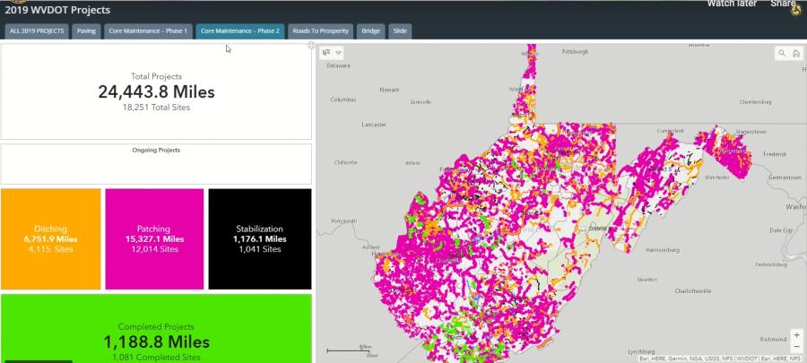
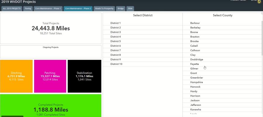
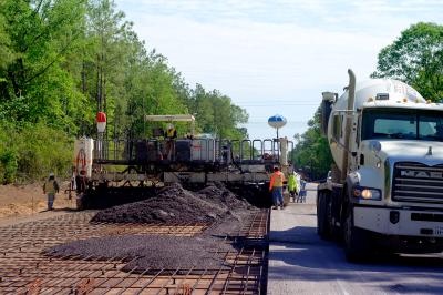
Leaders with the West Virginia Department of Transportation unveiled an all-new, interactive, web-based map that shows every road project going on across the entire state.
The map also provides real-time statistics on how much road work has been completed across a variety of categories, including Gov. Jim Justice's Secondary Roads Maintenance initiative and Roads to Prosperity program.
"Under the leadership of Governor Justice, we have stated that we were going to provide a way to show the public, in a transparent way, the progress we have made in a short amount of time," Secretary of Transportation Byrd White said. "This interactive website allows everyone who's interested to see what's been done and what will be done, before the end of the year. It's pretty remarkable."
The map currently displays all road projects for the year 2019; including projects that are currently underway, ones that are about to be started, and ones that have already been completed.
"This is an incredible tool for the people of West Virginia to be able to see exactly where our crews will be and when they'll be there," Deputy Secretary of Transportation Jimmy Wriston, P.E. said. "This is a more comprehensive mapping tool than the public has ever had access to before."
Users of the interactive map are able to search their location by typing in a specific address. Users also are able to search by city, county, or Division of Highways district to pinpoint any area they would like to observe on the map. Users also can zoom and drag the map to adjust their view to see roadwork that's completed, underway, or scheduled for roads nearby.
Any road that is color-coded means that road is either slated for future work, work is already underway, or work has already been completed in that location. Users can see details about any specific project just by clicking on any color-coded section of road. An information box will pop up with more information about the associated project.
Some roads may have more than one project happening and are marked with more than one color. Users are able to see the different types of work on these types of roads by clicking arrows within the information box to cycle through projects.
Users also are able to use tabs along the top of the webpage to filter searches for specific types of road projects. One specific tab is dedicated to tracking paving projects. There are also tabs for Core Maintenance, which specifically show work done to fix the state's secondary road system since Gov. Justice's directive to make these types of roads the DOH's top priority. "Phase 1" core maintenance projects were originally identified as needing fixed between March and June. While "Phase 2" core maintenance projects were originally identified as needing fixed from July to present.
Other tabs are available to view progress made to major roadways as part of Gov. Justice's Roads to Prosperity program, as well as bridge projects and slide repairs throughout the state.
This interactive application was created by the DOH Planning Division's award-winning GTI section, who recently won a Special Achievement Award in GIS at this year's Esri User Conference in San Diego.
"This is going to be the go-to, complete tool for people to use to know when roads in their area will be fixed. There is so much information here it's really hard to believe," Wriston said. "And to have this done, in-house, by our incredible team with DOH means that the production of this map came at a cost-savings of well over a million dollars versus what we would have had to pay for an outside company to produce it. Not to mention we made this map in just a couple of months when an outside company would have likely taken in the neighborhood of a year to 18 months to deliver."
Currently, the map displays only projects scheduled for calendar year 2019. However, future updates to the map will include additional projects scheduled for 2020 and beyond at a later time.
The release of this map coincides with DOH district offices utilizing a new internal data system to track projects. Engineers and district managers will be able to enter project data directly into that system, which goes on to feed the map itself, keeping road progress statistics up to date.
The map's data, including the status of each project, will be updated approximately every two weeks as roadwork continues.
The map can be found here: https://transportation.wv.gov/Pages/2019-WVDOT-Projects.aspx.
Construction Equipment Guide
470 Maryland Drive
Fort Washington, PA 19034
800-523-2200
Construction Equipment Guide covers the nation with its four regional newspapers, offering construction and industry news and information along with new and used construction equipment for sale from dealers in your area. Now we extend those services and information to the internet. Making it as easy as possible to find the news and equipment that you need and want.
Contents Copyrighted 2024, by Construction Equipment Guide, which is a Registered Trademark, registered in the U.S. Patent Office. Registration number 0957323. All rights reserved, nothing may be reprinted or reproduced (including framing) in whole or part without written permission from the publisher. All editorial material, photographs, drawings, letters, and other material will be treated as unconditionally assigned for publication and copyright purposes and are subject to Construction Equipment Guide’s unrestricted right to edit and comment editorially. Contributor articles do not necessarily reflect the policy or opinions of this publication.
Read our privacy policy here.
Mastodon