


Our Main Office
Construction Equipment Guide
470 Maryland Drive
Fort Washington, PA 19034
800-523-2200
Mon April 10, 2006 - Southeast Edition
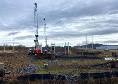
It has been 40 years in the making, but before long the city of Roanoke will experience less devastating floods that have plagued the city for years.
The start of the Roanoke flood control project is a result of recent cooperation between the U.S. Army Corps of Engineers, the city of Roanoke and Congressional representatives.
The Roanoke-based Branch Highways Inc. was awarded a $3.8-million contract for initial improvements in phase one of the two-phase project.
The project consists of 6.2-mi. (10 km) of channel widening along 10 mi. (16 km) of the Roanoke River, plus construction of a greenway along the entire length of the river through the city of Roanoke. In normal conditions, or non-flood times, the greenway will be a park-like feature in the downtown area.
The Wilmington District of the U.S. Army Corps of Engineers is overseeing the $65- million flood control project. Groundbreaking for the first phase, which extends from the regional sewage treatment plant in Southeast Roanoke and up the river toward Wasena Park, was held in October 2005 and has a completion date of 2007. The second phase will continue from Wasena Park to the Salem City line and has a completion date of 2010.
The flood control project will not eliminate flooding in Roanoke, but it should make small floods harmless and reduce the amount of flooding from major storms. In the past, rains from major weather systems have pushed water from the Roanoke River out onto the city streets and into a large part of the downtown area. When the project is finished, the channels should be able to carry heavier flows during flood events and flood stages will be lowered by 1 to 3 ft.
According to Mike Higgins, project manager of Branch Highways, the flood control project was “designed for two- to three-year frequency floods that Roanoke experiences and not for the 10-, 15-, 50- or 100-year flood.”
The contract awarded to Branch Highways includes excavating four bench cuts in four locations between 9th Street and the regional sewage treatment plant. Branch is installing bench cuts by excavating existing material in order to widen the footprints of the river banks and create additional water storage areas.
Higgins explained it as “excavating a cross section of the river bank allowing additional ponding or flooding areas before [the water] goes over the river banks.”
Workers are excavating at a minimum depth of 6 to 10 ft. (1.8 to 3 m) and a maximum depth of 25 ft. (7.6 m).
“Most were 20 to 25 feet in depth,” Higgins said.
The excavators are removing both natural and manmade materials as well as any obstacles that might impede rising and receding floodwaters. Branch Highways is making use of a John Deere 330 excavator and a Volvo 25-ton (23 t) articulated dump truck on this project.
Removing Remnants of the Past
In years past, a thriving industrial area existed along the river. As a result, unused structures, like an old factory, have to be removed from the river’s banks. So far, 135,000 cu. yds. (103,000 cu m) of material, including dirt, building rubble, vegetation, trash, industrial debris and other materials, has been removed. The existing dirt made up the largest quantity of the total amount removed. Even so, Higgins stated, “We only removed what we needed to for construction.”
The project has an extensive environmental protection plan, so it must be in compliance with all environmental, erosion-control and endangered species laws. As part of these regulations, workers are using low earthen dikes, siltation fencing, silt basins, soil-stabilizing mats and a variety of other erosion-control safeguards. A turbidity curtain also has been installed at the job site.
“It keeps any sediment that might leave the job site from getting into the river,” Higgins said.
Also, in the process of excavating, workers have encountered contaminated materials, which had to be remediated under state and federal regulations.
Branch’s contract also includes the extension of a short section — less than 1,000 ft. (305 m) long — of a recreational trail. Work on the trail will continue in future contracts as part of the overall flood control project. Additionally, Branch will be landscaping its project area with trees and grasses native to the Roanoke area.
Congressman Bob Goodlatte, who was instrumental in securing funding for the project, envisions a prominent riverside area when the project is completed. The U.S. Army Corps of Engineers’ Wilmington District News of October 2005 said that Goodlatte “expressed optimism that the careful design and high environmental values of the project would put it on a par with other well-known projects around the nation, like the San Antonio River Walk.”
Jan Brodmerkel, project manager for the U.S. Army Corps of Engineers, gives an indication of just how long the community has been anticipating this project.
“I was six years old when the city of Roanoke and the Corps started working toward this project,” she said. CEG
Construction Equipment Guide
470 Maryland Drive
Fort Washington, PA 19034
800-523-2200
Construction Equipment Guide covers the nation with its four regional newspapers, offering construction and industry news and information along with new and used construction equipment for sale from dealers in your area. Now we extend those services and information to the internet. Making it as easy as possible to find the news and equipment that you need and want.
Contents Copyrighted 2024, by Construction Equipment Guide, which is a Registered Trademark, registered in the U.S. Patent Office. Registration number 0957323. All rights reserved, nothing may be reprinted or reproduced (including framing) in whole or part without written permission from the publisher. All editorial material, photographs, drawings, letters, and other material will be treated as unconditionally assigned for publication and copyright purposes and are subject to Construction Equipment Guide’s unrestricted right to edit and comment editorially. Contributor articles do not necessarily reflect the policy or opinions of this publication.
Read our privacy policy here.
Mastodon