


Our Main Office
Construction Equipment Guide
470 Maryland Drive
Fort Washington, PA 19034
800-523-2200
Wed November 24, 2004 - Southeast Edition
If one wants to develop property in Florida, he or she needs to look below the surface.
Florida is famous for its beaches and wetlands, both of which mean an elevated water table. The state of Florida is a karst terrain, generally underlain by limestone, inwhich the topography is chiefly formed by the dissolving of rock. It is commonly characterized by karren, channels or furrows caused by solution on massive bare limestone surfaces; closed depressions, subterranean drainage, and eaves.
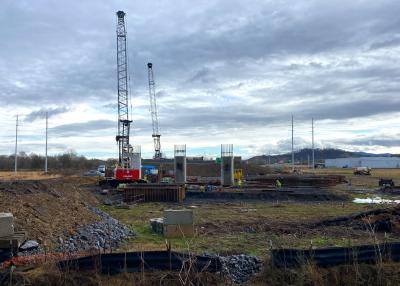
Before a design engineer or a contractor can decide the feasibility of the design and the best place to build, he or she needs to conduct a thorough investigation of what is going on below the surface.
The heavy rains from recent hurricanes Charley, Frances, Jeanne and Ivan poured water onto already saturated ground, bringing up the water table rapidly, causing spillage down into the subsurface caves. Erosion of the limestone layer is an ongoing problem. Rivers change courses below and above the surface. As one area erodes, the sandy and clay layers shift to fill in the gaps, causing surface depressions. Sinkholes appear.
“There were more and larger sinkholes that opened up in the Orlando and Gainesville areas after the hurricanes than in the Tampa Bay area,” said K. Michael Garman, senior project manager of Subsurface Evaluations. “Historically Tampa’s sinkholes tend to be small, where Orlando has big ones. St. Petersburg has not had a lot of sinkholes.”
The geological structure of the subsurface has to be mapped and measured.
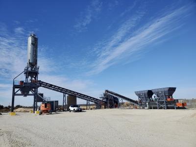
Geo-technical engineering detects and delineates karst features, confining clay layers, buried sinkholes, and soil cavities with the use of Ground Penetrating Radar (GPR). Subsurface Evaluations uses three units of GSSI Subsurface Interface Radar (SIR) equipment to do the job: SIR 20, 2000, and 3000. The Supersting R8 by AGI of Austin, TX, does the Electrical Resistivity Imaging (ERI),
“GPR is good to about 20 feet below the surface. Radar will detect buried debris and organic deposits as well as other features,” said Garman. “Changes from sand to clay to limestone produce different reflections allowing you to see soil layers. Whether or not they are horizontal, show a down warp or disappear tells you about subsurface structure.
“Sometimes a soil layer will disappear because a sinkhole has developed in the past and a sand layer filled it in. Called buried sinkholes, these indicate possible unstable features. Some have been filled in and are stable, but the only way to know for sure is to bore,” he said. “Radar shows structure but does not show density. You still have to do soil boring so you can identify what is happening.”
ERI works on the principle of voltage equals current times resistance. A known amount of current is injected and volts are measured at the receiving end. From there resistivity can be calculated. This process is repeated thousands of times over the site using computerized equipment with 121 electrodes that send and receive. From these readings comes a subsurface map of the area. Sands have high resistance, clays are conductive lows and limestone is medium.
“There are usually clay layers above limestone, so if we look and see areas that are broke, it indicates the need to look further for sink holes,” explained Garman. “Also, if the limestone has lower resistivity, it may mean limestone is weathered and weak.”
The geologic features discovered by ERI may recommend test borings to further determine stability of property. The geo-technical engineer as the designer of foundation of the structure needs to be able to determine where to put his test boring. ERI helps correlate this test area to determine where to put the bore. Since geologic features borings are only a few inches across, without mapping he might miss the best place to bore and miss a potentially costly problem.
Without imaging soil conditions, checking for peat and clay deposits beneath roadways, analyzing soil characterization and soil sampling, chances for disastrous results are increased. Subsurface Evaluations also can locate buried tanks, drums, waste-disposal trenches, and land fills and map environmental contamination plumbs, take ground water sampling and map saltwater intrusion.
(Garman is both a Professional Engineer (P.E.) and a Professional Geologist (P.G.) He has a bachelor’s degree in Civil Engineering from Vanderbilt University, a master’s degree in Physical Oceanography from Florida State University and is a PHD candidate in Microbiology at University of South Florida.)
Construction Equipment Guide
470 Maryland Drive
Fort Washington, PA 19034
800-523-2200
Construction Equipment Guide covers the nation with its four regional newspapers, offering construction and industry news and information along with new and used construction equipment for sale from dealers in your area. Now we extend those services and information to the internet. Making it as easy as possible to find the news and equipment that you need and want.
Contents Copyrighted 2024, by Construction Equipment Guide, which is a Registered Trademark, registered in the U.S. Patent Office. Registration number 0957323. All rights reserved, nothing may be reprinted or reproduced (including framing) in whole or part without written permission from the publisher. All editorial material, photographs, drawings, letters, and other material will be treated as unconditionally assigned for publication and copyright purposes and are subject to Construction Equipment Guide’s unrestricted right to edit and comment editorially. Contributor articles do not necessarily reflect the policy or opinions of this publication.
Read our privacy policy here.
Mastodon