List Your Equipment  /  Dealer Login

Massachusetts Looking to Turn Boston-Area Street Into Shared-Use Pathway

Wed March 27, 2024 - Northeast Edition #8
StreetsblogMASS


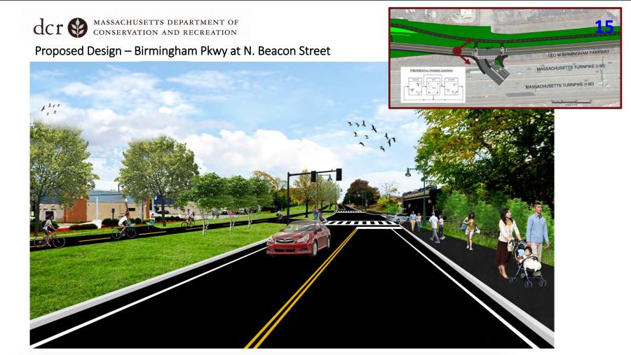
Rendering courtesy of the Massachusetts Department of Conservation and Recreation

The Massachusetts Department of Conservation and Recreation (DCR) is moving ahead with plans to transform a portion of the Leo Birmingham Parkway in the western Boston neighborhoods of Allston and Brighton into one with a smaller footprint and a new shared-use pathway.

The news was reported March 25 by StreetsblogMASS, a non-profit online news source based in Boston.

The Birmingham Parkway is currently a four- to six-lane highway that runs parallel to three other highways along the south bank of the Charles River west of downtown Boston.

It currently has no sidewalks for most of its length, and its two existing crosswalks are at either end of the highway, over a half-mile apart from each other.

Under the DCR's plans, the parkway's width would be cut in half, replacing a divided four-lane highway with a 30-ft.-wide, two-lane city street, and a much narrower 12-ft.-wide shared-use path running parallel on the north side of the roadway.

The plan also would install new traffic signals at Birmingham Parkway's intersection with Beacon Street on its western end, and at the three-way junction of Birmingham, and Market and Lincoln streets on the eastern end, StreetsblogMASS noted.

According to a public hearing the DCR hosted in February, the agency hopes to finalize the project's blueprints in the next few months and have the project ready to go to bid for construction this summer.

A Bypass of a Bypass

The Charles River shoreline is notoriously choked with DCR-owned riverfront highways of dubious utility, StreetsblogMASS said.

But this section of the riverfront in Brighton is an especially egregious example of the agency's century-long campaign to pave the Commonwealth's riverfront parkland.

Along this mile-long stretch of the river, the state agency maintains the four-lane Soldier's Field Road, the four- to six-lane Arsenal Street, and the two- to three-lane Greenough Boulevard — and all of those DCR-controlled highways run parallel to the eight-lane Massachusetts Turnpike.

That Birmingham Parkway exists at all turns out to be a historic fluke.

According to the National Register of Historic Places entry for the Charles River Reservation, "While the [Metropolitan Parks Commission] and its successor after 1919, the Metropolitan District Commission (MDC), acquired as much land as it could along the riverbanks, in some cases land was not available. Such was the case with the Brighton Abbatoir (a slaughterhouse) located just west of Market Street along the southern edge of the river. Since a river parkway was not feasible initially in that section, the MDC routed the parkway a short distance to the south of the river. This segment, completed in 1936, was known as Leo Birmingham Parkway. Ironically, it was only a few years later, in the 1940s, that the abbatoir closed and the MDC was able to acquire land along the river, allowing the extension of Soldiers Field Road from Arsenal Street to North Beacon Street."

The opening of the Massachusetts Turnpike in the late 1950s made the Birmingham Parkway even more redundant for motor vehicle traffic, the Boston news source reported.

DCR Plan Hinted at Eliminating the Road Altogether

In the DCR's official Parkways Master Plan, published in 2021, the agency confirmed that "regional traffic demand is served by adjacent corridors" and suggested that future plans for the highway should investigate the possibility of getting rid the road completely.

"The parkway can be restored to parkland with through access for non-motorized users," the Parkways Master Plan noted. "Recreational facilities could be added, such as playing fields, a skate park or an open-air restaurant."

If the DCR had pursued that recommendation, an additional 2 acres could be available for new recreational facilities and greenery.

StreetsblogMASS reached out to the DCR March 25 to understand why it decided to use the state's tax dollars to re-bury the parkland under 2 acres of asphalt instead. In addition, the news source asked the agency how much it plans to spend on the new roadway project but did not receive an immediate response.


Today's top stories

Blalock Crews Build TDOT's $67M Newport Bypass

New Bridges Part of Iowa's $114M Madison Avenue Project

Eagle Bridge Co. Works On Final Leg of U.S. 35 Upgrade

SAKAI Achieves Record Sales, Production

Takeuchi Recognizes Top Dealers at 2024 Dealer Summit

Equip Expo's Summer Giveaway Offers a Chance for Lifetime Trade Show Registration, Gift Card, Hotel Stay

Tennessee's Pugmill Systems LLC Expands Its Product Offerings to Include Concrete Plants

ASCENDUM Machinery Opens New Savannah, Ga., Facility


aggregateequipmentguide-logo agriculturalequipmentguide-logo craneequipmentguide-logo forestryequipmentguide-logo truckandtrailerguide-logo
39.96250 \\ -83.00610 \\ Columbus \\ PA