
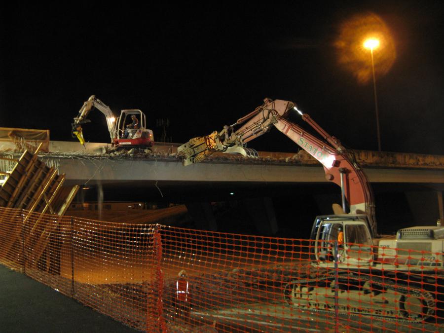
Most of Oregon's bridges were built before modern seismic design specifications were developed in 1990. Five of them along the Interstate 5 corridor in the Portland metropolitan area are undergoing an upgrade in order to meet those specifications so that they may remain passable if Oregon experiences a powerful earthquake.
That likelihood was documented in research conducted by the Oregon Department of Geology and Mineral Industries, which reported that there is a 40 percent chance that an earthquake similar to the 2011 Tohoku Earthquake in Japan will take place along the Oregon coast sometime in the next 50 years. The last "megathrust," or subduction zone, earthquake in this region was the Cascadia earthquake in 1700, which had a magnitude 8.7 to 9.2. (The 2011 Japanese earthquake, also a megathrust earthquake that included sustained shaking of the ground, was a magnitude 9.0.)
As a result of that study, ODOT conducted a seismic vulnerability study of state highway bridges to assess the risks to Oregon's only north-south interstate highway. Only a small portion of I-5 would remain passable if the state suffered a substantial seismic event. The study determined that most of the older bridges would either collapse or experience severe damage and become impassable without major, costly repair work.
Oregon's
Resilience Plan
The combination of strong and prolonged ground shaking, followed by a powerful and destructive tsunami, as well as multiple strong aftershocks in the succeeding days and months, makes the Cascadia subduction zone earthquake the most dangerous natural hazard for Oregon, especially for the state's coastal communities. The ground shaking will produce destruction of buildings and roads, take down power lines, block streets, rupture gas lines and break water and sewer lines. Many areas will be virtually uninhabitable.
Interstate 5 is expected to be the main corridor of traffic flow after a Cascadia subduction zone event because U.S. 101 is expected to be impassable, due to its location and capacity. I-5 will be the main route for emergency response.
A resilient transportation network is considered critical for re-establishing other lifelines, such as water, electricity, fuel, communication, and natural gas, after a major Cascadia subduction zone earthquake. But the system's current state of vulnerability to ground shaking and tsunami inundation means earthquake damage is expected to have devastating effect.
Most of Oregon's highways were constructed prior to design codes and before the potential effects of the Cascadia subduction zone were studied. Therefore, many bridges and unstable slopes are vulnerable to severe damage, making it equally problematic for evacuation of the area during critical events and for emergency access by first responders.
To assess the status and determine appropriate levels of resilience, a task group consisting of representatives of each mode of transportation, including highways, rail, airports, water ports, and transit, along with representatives of local agencies, collected data and formulated a plan to increase the survivability of citizens and critical features of the built environment.
The task group assessed the transportation network in four geographical areas:
• The tsunami inundation zone along the coast (based on DOGAMI maps)
• The coastal zone (the area outside of the tsunami zone, from the Oregon coastline to the summit of the Coast Range)
• The Willamette Valley zone (from the summit of the Coast Range to the summit of the Cascades)
• The central Oregon zone (east of the Cascades summit)
They also established resilience targets for transportation facilities, which align with a phased, three-tiered approach to the restoration of the transportation network. This approach focuses on the need to optimize post-earthquake response and the need to establish priorities for making future investments to achieve the targets. The group prioritized highways into three tiers:
• Tier 1 is a small backbone system that allows access to all vulnerable regions and major population centers and areas considered vital for rescue and recovery operations.
• Tier 2 is a larger network that provides access to most urban areas and restores major commercial operations.
• Tier 3 is a more complete transportation network.
According to the task group, "the most important segment of Oregon's transportation network may be fragmented, with some areas not operational after such an earthquake, depending upon the intensity and epicenter of the quake and its aftershocks."
The susceptibilities of Oregon's bridges are complex. Each bridge and each site has different weaknesses. Some bridges are prone to more than one type of seismic deficiency. While some can be successfully retrofitted, a few may need to be replaced.
Under the Oregon Transportation Investment Act program, ODOT replaced several deficient structures along this route; however, the main criterion for the selection of which bridges to replace was based on the need to support current truck load requirements, not to meet seismic standards. That means that some of the bridges already identified as vulnerable to earthquake shaking are still in active service.
Out of a total of 348 bridges carrying both northbound and southbound traffic, five bridges are expected to collapse and 19 bridges to be heavily damaged during a Cascadia subduction zone event.
Retrofit
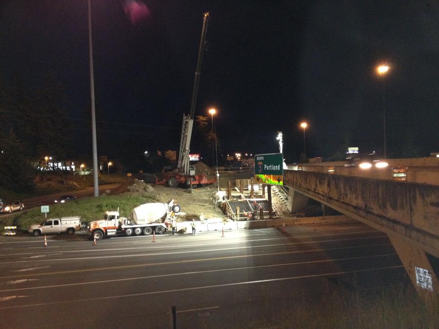
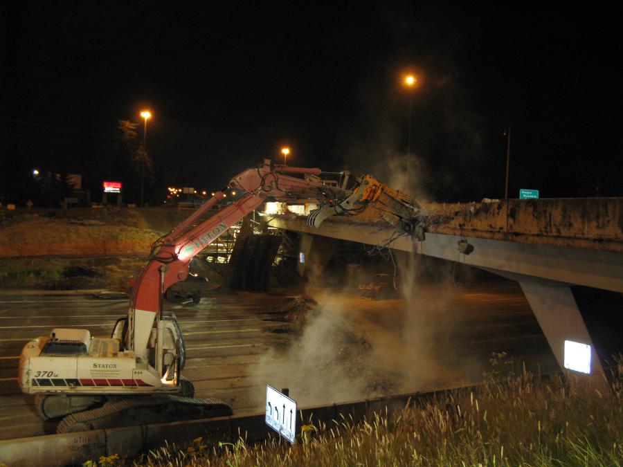
Designed by HDR and Quincy Engineering Consultants, this two-season seismic retrofit project will strengthen five separate bridges spanning a 10-mi. (16 km) section of I-5 and give them the ability to withstand a major earthquake by focusing on retrofit elements that meet modern seismic specifications. Strengthening the piers, pilings and bridge abutments will bring the structures up to modern seismic design specifications, which will make them better able to withstand a powerful earthquake.
Eighty-nine percent of the $9.9 million budget comes from federal funds and 11 percent from state funds.
Work began in March 2014 and is expected to be completed at the end of October 2015. Cascade Bridge LLC of Vancouver, Wash., serves as the general contractor, with 15 current subcontractors, including Parrish Excavating, R2M2 Rebar and Stressing and Pacific Foundations.
Bridge by Bridge
According to ODOT, the sites selected for updates represent the first phase of an expected multi-phase program to improve the seismic sufficiency of bridges throughout the region and state.
The first five bridges to undergo improvement have significant average daily traffic. Don Hamilton, Region 1 public information officer of ODOT, provided the 2012 numbers for locations at or near these five projects:
• I-5 at Hood Avenue: 117,800
• I-5 at Barbur Boulevard: 95,800
• I-5 at Portland Western Railroad: 154,300
• I-5 at Lower Boones Ferry Road: 153,200
• I-5 at Tualatin River Bridge: 134,400
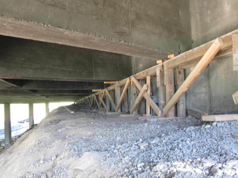
Each bridge is unique, said Hamilton. Although the primary retrofit work involves infill walls, with some footing work and thickened bents to stiffen bridge members, each design is individually tailored to the bridge's needs and includes additional work.
1. Hood Street Ridged Frame involves infill walls between all four supports and 96 post-tensioned infill wall footing anchors at the two bents adjacent to traffic. ADA features also are part of the scope for this bridge as well as providing ornamental security fences to keep trespassers away. Work at this site is nearly half complete.
2. Barbur Blvd. Bridge is a pre-stressed beam bridge. Retrofit work will include shear lugs and bolsters. Work is scheduled to begin on this bridge in fall 2014.
3. Cook Structure carries I-5 traffic over the PN&WR Railroad. A footing will be widened and infill walls installed. A crash wall will be removed and replaced. Work is scheduled to begin on this bridge in fall 2014.
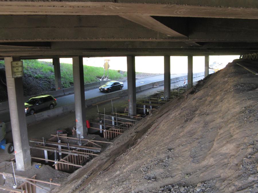
4. Lowe Boones Ferry Bridge carries a local roadway that is part of a major interchange that serves many businesses, including shopping malls and a park and ride facility. Retrofit work includes infill walls with footings, CIP retaining walls, slope paving and ornamental security fence. It also includes both temporary and permanent ADA facilities. The structure will be widened to provide a future SB lane for I-5.
Outside of the scope of the seismic retrofit, a large and uniquely constructed portion of the project involved widening the LBF Bridge. "A CIP reinforced bridge beam will be cast on falsework, adjacent and parallel to southbound I-5 lanes and lifted into place on new footings and columns matching new CIP approach spans, from each end, providing for one future additional southbound lane," Hamilton said. "This lane will receive a Polyester Polymer Concrete overlay matching the existing lanes."
5. Tualatin River Bridge is a water crossing that primarily thickens the existing bents at infill walls and columns. A structural steel channel brace also is included below the web wall. A new drainage system will be incorporated for environmental reasons to carry drainage off the bridge ends for treatment before finding its way to the river. Work at this site is under way and slightly ahead of schedule for delivery this year.
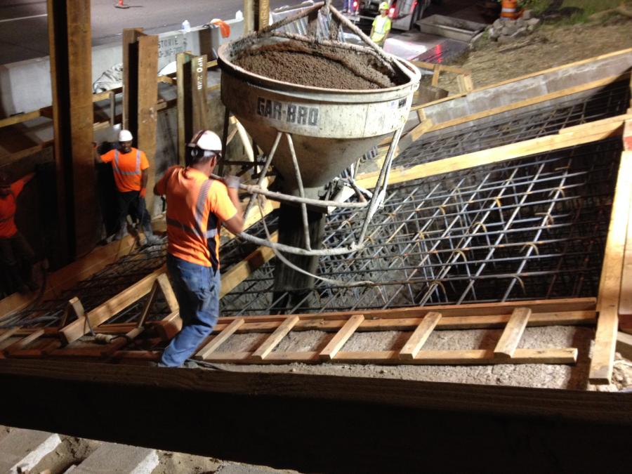
A total of 3,385 cu. yd. (2,588 cu m) of reinforced concrete and 632,000 lbs. (286,670 kg) of reinforcing steel will be used for all five bridges. Other materials include 96 footing anchors per bridge and 13,346 resin bonded anchors for each bridge.
Hamilton lists equipment required for the job: excavators, drills, concrete pumps, cranes, pavers, dump trucks, mills and mobile mixers (anticipated in 2015).
Approximately 10 to 15 crew members are working at each of the three current active job sites.
The Hood
The I-5 Bridge over SW Hood Avenue is one of five bridges between Portland's South Waterfront district and the Tualatin River. Work on this stage of the project began in March 2014 and is expected to continue for six months.
Work includes seismic retrofitting on the northern bridge abutment and beam, including footing work, removal and replacement of sidewalk and curb, pavement repair and replacement of damaged signal detection hardware. Bridge columns will be strengthened with in-fill walls and the bent caps will be reinforced. Pier wall footings will be enlarged and reinforced. In addition, new lighting fixtures and ornamental security fencing will be installed. "We're doing a lot of micro pile-driving to reinforce the anchors," Hamilton elaborated.
During this phase, a detour route will be in place for approximately 12 months, while alternating lane closures of one of the two travel lanes on SW Hood Avenue permit crews to work. "There will be no full directional closures; that's a priority. We don't want to take a major component out of commission."
Near Hood Avenue, he said, between Interstate 5 and the Willamette River, is a 1500 ft. (500 yd) stretch of land that used to be the site of the old shipyards. Over the past 15 to 20 years, this area has been developed. The South Waterfront district features apartments and part of a college campus.
Located on I-5 over SW Hood Avenue in Portland's South Waterfront district, the bridge will be directly above the work taking place on SW Hood Avenue. "One of the biggest challenges has been figuring out how to keep I-5 open during the project as much as possible," Hamilton said "We're trying to avoid delays and slow-downs. The problem is diverting traffic to get to that area. There are a lot of traffic control issues."
A partial solution is a noise variance from the city of Portland that allows nighttime construction work. Hamilton said most lane closures will be done at night to reduce the impact on traffic.
Close Quarters
Traffic and access — for motorists, pedestrians and for construction equipment —have posed challenges, but they haven't been the only ones. Hamilton lists others, such as confined work space, working adjacent to the railroad and disrupting homeless camps.
To deal with the biohazards from the homeless camps, he said crews have utilized maintenance forces and a specialty sub to clean the camp and surrounding area of waste, including needles.
The DOT made an agreement with the adjacent property owner to allow access to the railroad at the Cook site. "Access to the Tualatin River is requiring the contractor to build a three-level platform with a containment system to allow drilling, installing rebar and pouring concrete without impacting the river." Accommodations for the wetlands have been built into the schedule. All work must be complete at this site during the In-Water Work period (June 1 to Sept 30).
Temporary ADA access is being provided at the LBF site by separated paved paths and the contractor is expected to provide ADA access at each site at all times during construction.
Good Neighbors
Work is on schedule, with no surprises to delay construction. "It's almost routine," Hamilton said, adding that work is progressing in a "predictable sequence." Because there is no digging, there are no surprises to uncover, he said. "It's mostly concrete pouring."
Drivers shouldn't have any surprises either, after a pre-construction public outreach program and open house, as well as ongoing outreach, particularly to a hospital campus near the Hood site to facilitate access for patients and deliveries, and to a major shopping mall to discuss detours and closures at the LBF site.
Hamilton said ODOT's Mobility Program provides notices to trucking interests in advance of work. Drivers will occasionally be stopped by flaggers or directed to travel out of direction on pre-determined detours during partial and full closures, but by coordinating with the city and getting word out to the public, Hamilton expects traffic to flow smoothly.


