


Our Main Office
Construction Equipment Guide
470 Maryland Drive
Fort Washington, PA 19034
800-523-2200
Thu June 23, 2016 - National Edition
Drone-based mapping is already bringing enormous insights and efficiency gains to a variety of industries. The ability to quickly get an overhead view of a job site is very useful for site planning and communication — but for many industries, particularly construction and mining, using drones to understand elevation data is even more valuable.
In February, we released our initial elevation and volume tools, which gave users a way to capture relative elevation data and measure stockpile volumes in a way that was faster and more cost-effective than ever before. With just one 15 minute flight, users can collect elevation data that would have taken hours — if not days — to collect with traditional ground-based surveying methods.
That initial release was just the beginning. In the last four months, we've worked with our users to better understand how they use elevation data in their businesses, and we are excited to announce several new improvements to help make the elevation data in DroneDeploy even more powerful.
View the Elevation of a Point
It sounds like a simple thing, but the ability to immediately view the elevation of any point when you drop a marker on your map can be used for a variety of different purposes. With this new capability, it's easy to measure the height of a structure or use the elevation and distance between points to calculate slopes, and more.
Note: Unless corrected with ground control points (GCPs, available on our Premier plan), elevation data reflects height in feet or meters relative to point at which the drone took off.
Calculate Volumes of Benches and Walled Piles
The original version of the volume tool released back in February allows users to outline a formation, e.g., a stockpile, and then instantly calculate the volume with a click of the button. Behind the scenes, DroneDeploy used the outline to define the “base” of the stockpile, and then compares the base to the surface of the pile to make the calculation.
The first version of the tool worked great for calculating stand-alone stockpiles on flat surfaces. In one case study, drone service provider Dallas VanZanten discusses how he used the DroneDeploy volume tool to calculate stockpile volumes at a granite processing plant to within 1% accuracy in a fraction of the time compared to traditional methods.
“Drones are safer, faster, and about half the cost as compared to traditional ground-based volumetrics.” — Dallas VanZanten, Skymedia Northwest
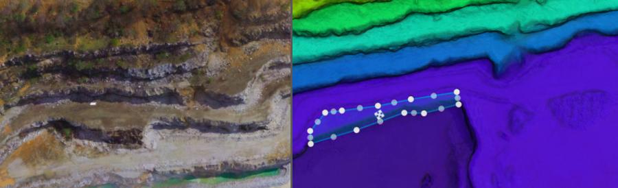
But what if you need to calculate the volume of a bench in a pit mine or walled stockpile where the base of the structure can't be easily defined by drawing a perimeter on the ground? A small adjustment to our volume tool now allows you to use the lowest selected point to define the base of the volume want to calculate, making the volume calculation useful and accurate for a broader range of volume calculations.
Now with you can use either method to calculate volumes.
Easily Export Elevation Data for Use in GIS Tools
Sometimes users want to combine elevation data from their maps with other data sets and tools in order to perform more complex analysis or design work. Imagine an architect using an elevation map of the existing site when designing a new building, or, as in a recent case study, a major construction company using drone elevation data to compare actual earthwork completed on site against design plans. To do this kind of comparative work, or even to generate contour maps, users need to import elevation data from DroneDeploy into third party software.
Previously, elevation data could only be exported from DroneDeploy as a point cloud, which is not compatible with many popular GIS tools and required substantial manipulation before it could be used to calculate elevations or generate contour maps. Today, users can instead export raw elevation values as a GeoTiff, making it much easier to import drone-based elevation data into ArcGIS, Civil 3D and other popular GIS tools.
Construction Equipment Guide
470 Maryland Drive
Fort Washington, PA 19034
800-523-2200
Construction Equipment Guide covers the nation with its four regional newspapers, offering construction and industry news and information along with new and used construction equipment for sale from dealers in your area. Now we extend those services and information to the internet. Making it as easy as possible to find the news and equipment that you need and want.
Contents Copyrighted 2024, by Construction Equipment Guide, which is a Registered Trademark, registered in the U.S. Patent Office. Registration number 0957323. All rights reserved, nothing may be reprinted or reproduced (including framing) in whole or part without written permission from the publisher. All editorial material, photographs, drawings, letters, and other material will be treated as unconditionally assigned for publication and copyright purposes and are subject to Construction Equipment Guide’s unrestricted right to edit and comment editorially. Contributor articles do not necessarily reflect the policy or opinions of this publication.
Read our privacy policy here.
Mastodon