
Lots of engineers are putting their skills to work around Fargo, N.D. They are involved in an ambitious attempt to regulate the flow of Red River water and tributaries through the border communities of Fargo and Moorhead, Minn. To that end, they are building a massive embankment, miles of levees, a long, long channel, aqueducts and huge flow-control gates.
Ground was broken on the biggest component of the project just last year, but other pieces have been under way for years. And it's all because of the Red River.
The stream is formally termed the Red River of the North, as opposed to the Red River of the South, which courses along the borders of Texas, Oklahoma and Arkansas. The northern Red drains parts of North Dakota and Minnesota on its way northward to Manitoba, Canada. When rain or snow-melt runoff can't be contained, the river leaves its banks disastrously — as it did in Fargo 14 years ago.
"We almost lost the community in 2009," said Joel Paulsen, executive director of the Metro Flood Diversion Authority, which oversees the sprawling flood control project. "Temporary levees were almost topped. We came within inches of the levees failing. They didn't fail, though, and we lost very few homes, but it was a wake-up call for the community."
Construction began that year on intown levees, a work that is 90 percent complete. Now other work is occurring in areas of Cass County bordering Fargo. All the work is keyed to keeping the river's flood level below the top of those intown levees. It is called the Fargo-Moorhead Area Diversion project and is a comprehensive approach to flood control.
In early planning stages, a diversion channel was planned on the east, or Minnesota, side of the twin cities. However, that route would not have intersected and accommodated flow from Red River tributaries and other streams on the west side.
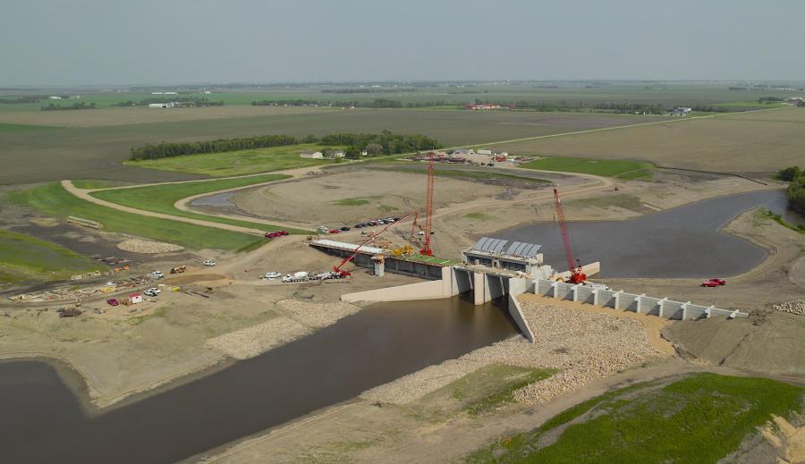
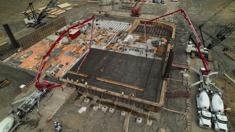
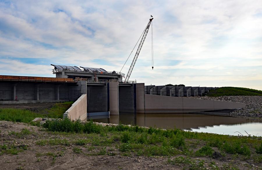
So, a diversion channel was designed instead for the North Dakota side of the metro area and is under construction. Where the north-flowing river approaches the south side of the cities, a "high-hazard dam" also is being built. The embankment structure incorporates two floodgates that can be lowered when waters of the Red River and the adjacent Wild Rice River reach dangerous levels.
Reducing the rivers' flow means that city properties will be spared flooding. However, the backed-up water then will spill out into a 20,000-acre flood plain south of the city. The impounded water subsequently will be released into the diversion channel and carried around the city to the north where the channel connects again with the Red River at Georgetown.
Sounds simple enough. It is the scale of the project that is daunting.
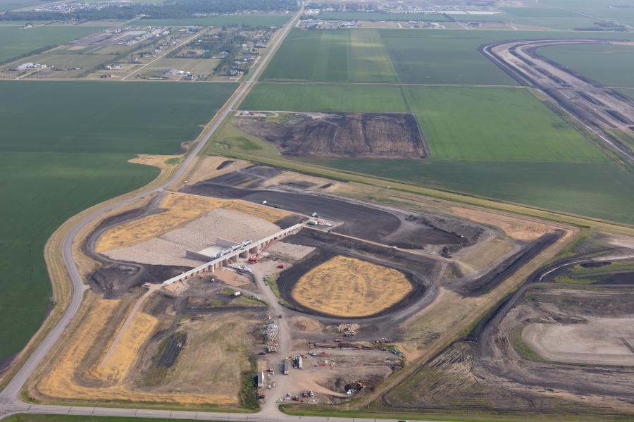
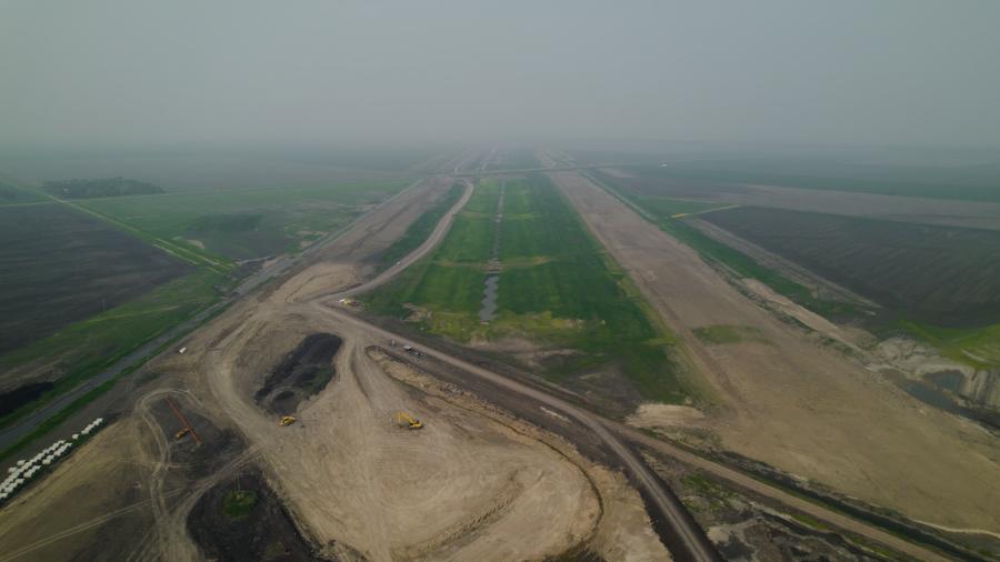
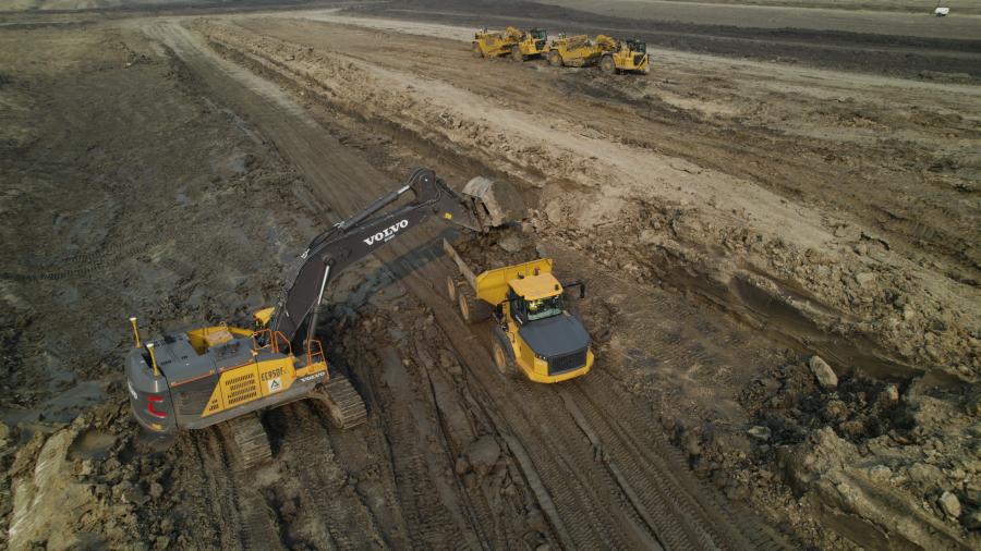
Creating the 30-mi.-long diversion channel will mean moving 45 million cu. yds. of soil. Mitigation projects to offset the destruction of natural habitat total some 1,800 acres. Radial arm gates on a diversion structure weigh 140 tons. Levees in Fargo and Moorhead total 35 linear mi. Then there are two aqueducts to be constructed where streams intersect with the channel; 11 inlet structures to be built where other drainages enter the channel; and 18 bridges to be erected where railroad tracks, interstate lanes and county roads cross the channel.
The footprint of the diversion channel, including earthen berms, is a half mile across, the channel itself about half that. It is being excavated in soils generally composed of silt and workable clay suitable for compacting into needed embankments.
"The clay is really, really good for levees and berms," Paulsen said.
Needed riprap and aggregate will be hauled in from deposits in North Dakota and Minnesota.
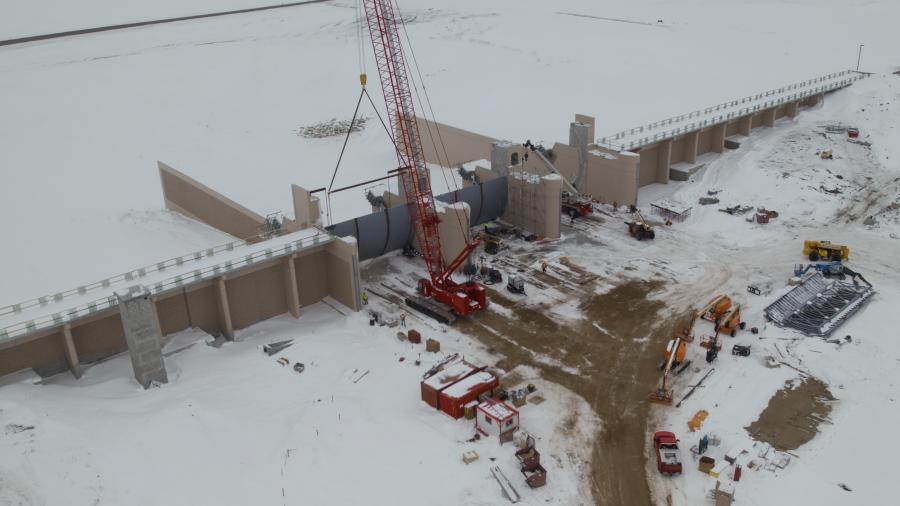
So far, the earth-moving part of the work has gone unexpectedly well. This is North Dakota, after all, where average January temperatures in Fargo range between 3 degrees and 19 degrees Fahrenheit. Yet somehow the colder weather this past winter proved a plus for moving earth.
"Our developer [Red River Valley Alliance] had higher production experience last winter than last fall," Paulsen said. "That's counterintuitive, I know, but the clay was more stable in the winter. I was surprised by how well things went."
The soil was dug up and shaped into berms in winter months but compacted in the spring.
All in all, dirt work was shut down in the winter only for a short-lived blizzard and for Christmas Eve and Christmas day. On the other hand, separate construction of concrete and steel structures was suspended during the coldest months.
The overall price tag at this point is $3.2 billion, according to the executive director. While that's a lot of money, it is roughly equivalent — in 1997 dollars — to the cost of the Red River Valley flood that year, which devastated communities in North Dakota and Canada. Adjusted for inflation, the flood today would be a $6.4 billion event.
Paulsen said a flood control project similar to this one was undertaken in the 1960s in Winnipeg, which also is on the Red River.
"The Canadians estimate some $40 billion in flood damage was avoided because of that project. We believe this one will perform just as well."
It is being funded at all levels of government. Some $750 million was pledged and delivered, partly through federal Infrastructure Investment and Jobs Act money. North Dakota legislators authorized another $850 million. Sales tax increases approved by Fargo and Cass County voters after the 2009 near-disaster bring in about $70 million each year. On the Moorhead side of the river, the city has authorized funding and the state of Minnesota appropriated $134 million.
As the years roll by, the cost of projects incrementally increases.
"Material prices go up," noted Paulsen, even though the private-public partnership secured fixed prices for much of the work. The executive director was asked if there has been much variance in public support of the project as it slowly unfolds.
"In the urban area, people generally are very, very supportive," he said. "They sigh with relief that they finally are going to get permanent flood protection. No more fighting floods in the spring. Out in adjacent rural areas, on the other hand, we have some folks that don't like the project. They will not receive many benefits from it and have filed lawsuits. In general, though, public sentiment today is really, really good."
Awards showered upon the project to date are keyed to the fact that it is a public-private partnership. It is, in fact, the first "P3" flood management project in North America and the first-ever public-private civil works project involving the U.S. Army Corps of Engineers.
The partnership agreement gives the Metro Flood Diversion Authority chief responsibility for the diversion channel and infrastructure intersecting it. The Corps is in charge of constructing the southern dam and its flood gates, which then will be operated and maintained by the Authority. City and county governments and the Authority share responsibility for levees and similar concerns. And the Corps and city and county officials together are responsible for the various mitigation projects (wetlands, cemeteries and so on).
The most evident impact of this shared responsibility is that the entire undertaking will be completed in 2027 — probably 10 years sooner than if undertaken as a traditional design-build task. That means flooding as an annual threat to residents and business owners of Fargo and Moorhead is being dramatically reduced sooner rather than later. The other obvious public benefit is that shorter construction periods cost less than longer ones.
Paulsen believes the P3 model is "groundbreaking. There are things here that can be replicated for other mega-projects across the country. We want to get the information out and share our best management practices."
The work isn't done yet, of course. The channel is only about 10 percent complete. The dam and floodgate work about 50 percent complete. Some outlet structures haven't yet been started. It is a work still in progress, with 30 or more contractors and consultants busily engaged.
Paulsen became Authority executive director four years ago — and had been involved in the project for several years before that. He said the intervening years have been challenging.
"The environmental permitting side of things was very difficult because we have a 10,000-acre footprint and 20,000-acre flood plain. Permitting procedures with Corps of Engineers and state natural resources agencies were difficult. Funding and financing were difficult to get together. Removing some homes and farmsteads and acquiring land took a while to work through."
Challenges remain, including finding enough heavy equipment operators and laborers to keep the dirt moving.
"We could have schedule delays if we can't find enough people."
Paulsen also expects some "unique challenges keeping the project on schedule with the thousands of reviews necessary in any P3 design/build project."
The good news is that not all benefits of the diversion project await completion. Though certain system components — such as the massive floodgates — cannot be legally employed until all the parts of the system are in place, according to the director, the work already is benefiting.
As the levees continue to be built in town, protection of neighborhoods increases. Work on the channel is incrementally protective.
"We've built four or five miles of the channel downstream and every time we get to an intersecting smaller river, there is a level of passive protection created. The more we build, the more Fargo will be protected."
The executive director brings almost a lifetime of experience to this task. He is a North Dakota native, grew up in Fargo, and witnessed more than one flood there.
"I remember looking at my uncle's house from a hilltop and watching it overtaken by the flood, with water rising to the eaves of the house. It was very impactful on my upbringing and may have pointed me in the direction of civil engineering."
On a lighter note, he recalls regularly playing with a friend in a sandbox where they would create structures, then build dams and levees and turn on the hose to see if they had built sufficient protection.
"At the end of the day, we always lost the structures, but we had a lot of fun doing it."
His work today is less "fun," more successful and is impacting tens of thousands of lives in sometimes interesting ways. Think flood insurance. More than 12,000 structures impacted by this project are in the flood plain. Paulsen said that translates to $60-80 million leaving the community each year in flood insurance premiums, a less-visible impact of flooding.
"It is a big financial motivator to get the project done." CEG


