


Our Main Office
Construction Equipment Guide
470 Maryland Drive
Fort Washington, PA 19034
800-523-2200
Wed August 19, 2020 - National Edition
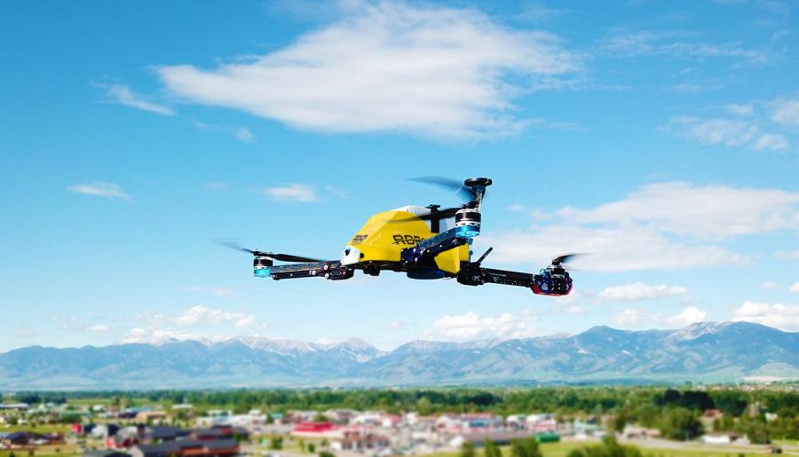
To address customer needs for a drone with more payload options, RDO Integrated Controls partnered with Vision Aerial in Bozeman, Mont., to develop a new unmanned aerial vehicle (UAV) primarily for construction and earthmoving companies.
Effective immediately, the new RDR series drones are available on www.rdomarketplace.com and RDO Integrated Controls will support the drones through its Solutions Center and Fleet Shield Services program.
Initially developed with a mapping component, the RDR series UAVs are customizable for companies needing various configurations, including LiDAR, hyperspectral, multispectral and thermal. Two models are offered: the RDROne drone is a tri-copter design, while the RDRTwo drone, designed for heavier payloads, is a hexacopter.
The drones are ideally suited for companies in the construction and aggregates industries, with custom options available for applications in agriculture, inspection, law enforcement and security, mining, oil and gas inspection, professional photography and cinematography, as well as survey.
The new UAVs give companies assurance they are in full compliance with rules and regulations on every job site. The Vision Aerial drones provide fast and accurate volume and grade measurement, to a 10th-ft. accuracy or better when used with ground control or the additional RTK systems now available, according to the manufacturer.
The drones are built to fly in winds up to 35 miles per hour and offer up to 35 minutes of continuous operation in a single flight.
The RDROne and RDRTwo are easy to use, even for first-timers, from set up and flight planning to easy automatic or manual flight. The drones are compatible with any photogrammetry data management software including RDO's new online product, RDOai, a cloud-based 3D data management system and analytics platform.
Regardless of software choice, both the RDROne and RDRTwo are supported by the RDO Integrated Controls Solutions Center, based in Billings, and customers may choose various levels of support through the company's Fleet Shield Services program.
For more information, visit www.rdoequipment.com.
Construction Equipment Guide
470 Maryland Drive
Fort Washington, PA 19034
800-523-2200
Construction Equipment Guide covers the nation with its four regional newspapers, offering construction and industry news and information along with new and used construction equipment for sale from dealers in your area. Now we extend those services and information to the internet. Making it as easy as possible to find the news and equipment that you need and want.
Contents Copyrighted 2024, by Construction Equipment Guide, which is a Registered Trademark, registered in the U.S. Patent Office. Registration number 0957323. All rights reserved, nothing may be reprinted or reproduced (including framing) in whole or part without written permission from the publisher. All editorial material, photographs, drawings, letters, and other material will be treated as unconditionally assigned for publication and copyright purposes and are subject to Construction Equipment Guide’s unrestricted right to edit and comment editorially. Contributor articles do not necessarily reflect the policy or opinions of this publication.
Read our privacy policy here.
Mastodon