
Purdue University civil engineers have developed a fully automated, portable system to estimate the volume of stockpiles of bulk supplies like salt and other materials used in industrial, highway and agricultural applications.
The Indiana Department of Transportation funded the research through its Joint Transportation Research Program. A paper about the innovation was published in the peer-reviewed journal Remote Sensing.
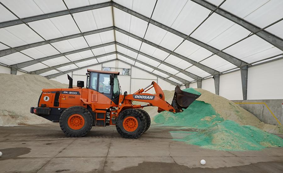
Stockpile management is important in roadway maintenance, which uses salt to deice roads to keep traffic flowing safely, and in other applications. Government agencies are increasingly interested in tracking stockpiles to assess their environmental impact, including effects on roadside vegetation and the salinity of surface water. Salt and sand also may affect pavement durability.
Jeremy McGuffey, statewide winter operations manager of INDOT, said the department has nearly 120 salt storage buildings around the state and that most locations visually estimate the volume.
"This is inherently incorrect and will vary from person to person," McGuffey said. "If I pointed to a pile of stone on the ground, could another person accurately tell me the volume of that stone based on sight alone?
"There are a few locations that use survey equipment to take measurements based on the exterior size — the height and width — of the stockpile, but those don't account for depth. Many of our buildings are full of salt year-round, and there is no way to reach the back side of the pile to determine how long it is."
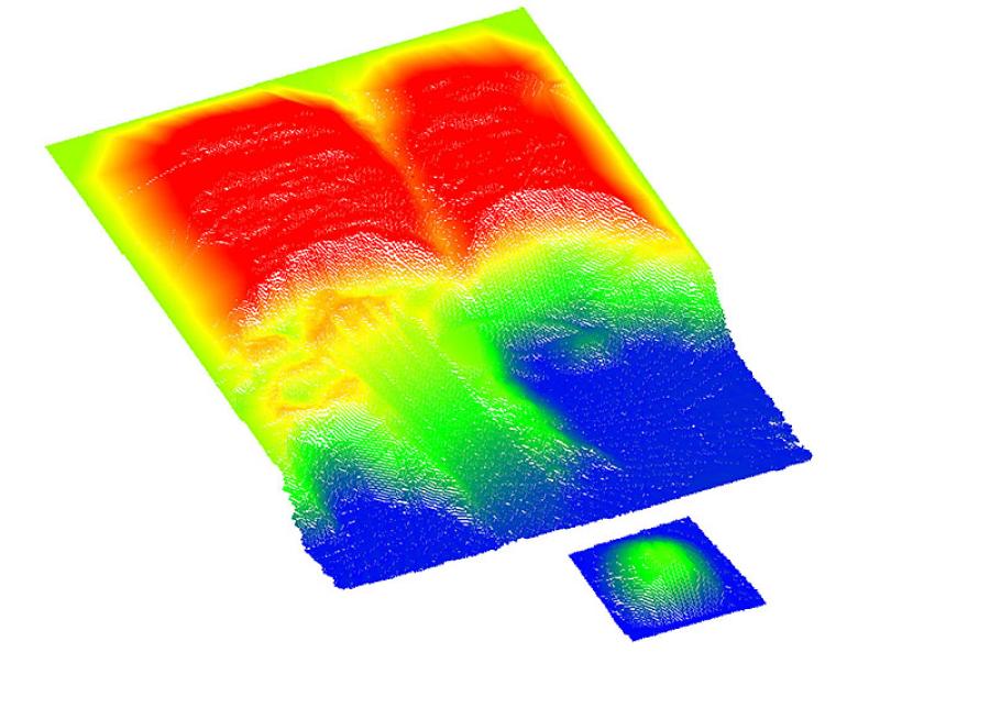
Traditional methods to measure stockpiles use field survey procedures that last several hours and expose surveying crews to dangerous conditions. Modern LiDAR technology — or light detection and ranging technology — is safer and more reliable, but its peak performance is confined to well-planned scanning and complex data processing schemes when dealing with large indoor sites.
Salt monitoring and reporting technology, or SMART, was created by Ayman Habib, the Thomas A. Page professor of civil engineering, and Darcy Bullock, the Lyles Family professor of civil engineering, both of Purdue's Lyles School of Civil Engineering.
Habib said SMART integrates consumer-grade sensing modalities of imaging and LiDAR units to acquire stockpile data in fewer than 10 minutes per facility, even in challenging environmental situations.
"SMART also uses an innovative data-processing strategy that can handle this data for accurate evaluation of stockpile volume as well as provide a visual record of the mapped facility in the form of colorized point clouds," Habib said.
SMART is more precise, more cost-effective and safer than traditional commercial technologies to estimate the volume of stockpiles of bulk materials.
"The technology estimates volume with less than 1 percent error and costs less than $10,000; existing technologies cost more than twice that," Habib said. "It also allows for practical, quick and safe data acquisition. Some traditional technologies require an operator to climb the stockpile, which leads to extended and unsafe data acquisition."
McGuffey said SMART has already brought positive results to INDOT.
"With the system we developed with Purdue, the empty dimensions of the building are solved for first, and then the salt pile's volume can be easily calculated. The LiDAR system bounces light off the pile millions of times to collect the information we need to determine the volume," McGuffey said. "The other huge plus is that this system is mostly automated with the only real human interaction being the initial install and then periodic cleaning."
Habib and Bullock disclosed the information to the Purdue Research Foundation Office of Technology Commercialization, which has applied for a patent from the U.S. Patent and Trademark Office. For information about licensing opportunities, contact Dhananjay Sewak of OTC at [email protected] about 2021-HABI-69512.
Habib said the next steps in developing SMART are to package the system so it can be permanently mounted in a storage facility to allow for automated data collection, to strengthen its ability to work in storage facilities with domed rooftops, and to enhance the value of the data by driving colorized points.
For more information, visit stories.purdue.edu.


