


Our Main Office
Construction Equipment Guide
470 Maryland Drive
Fort Washington, PA 19034
800-523-2200
Thu December 29, 2022 - Southeast Edition #1
In a historic decision, the U.S. Army Corps of Engineers (USACE) on Dec. 19 gave its approval to Louisiana's long-sought-after $2.3 billion Mid-Barataria Sediment Diversion on the west bank of the Mississippi River near the community of Ironton in Plaquemines Parish.
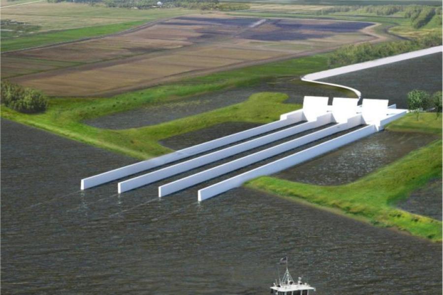
The Mid-Barataria Sediment Diversion would be the first effort of its kind, trying to mimic how the muddy river built south Louisiana over thousands of years before humans constrained it with levees. The goal is to reconnect the degraded wetlands of Barataria Bay with both freshwater and sediment, which in pre-levee days would have naturally and regularly filtered in from the Mississippi River, building land and supporting freshwater vegetation in the process.
According to Waterways Journal Weekly, the diversion structure will involve a break in the river levee just above Ironton, along with a canal extending 2 mi. to the southwest and ending in the upper reaches of Barataria Bay. The region is seeing some of the highest rates of land loss in a state that is losing about a football field of land every 100 minutes due to subsidence, erosion and relative sea level rise.
WWNO, New Orleans' National Public Radio (NPR) station, reported that the diversion is a key piece in the state's 50-year, $50 billion plan to support some of the state's lower third of land in the face of coastal erosion, sinking earth and global sea level rise.
The project, though, has been contentious due to the expected negative impacts it will have on marine mammals in the Barataria Basin, on commercial fishing in the area, and on navigation in the Mississippi River.
"We take great care to neither endorse nor oppose any project when administering our regulatory authorities," USACE New Orleans District Commander Col. Cullen Jones said in announcing its approval. "Our responsibility is to use the science, engineering, technology and data available to make the best-informed decision."
The Corps' will grant Louisiana's Coastal Protection and Restoration Authority (CPRA) two permits — Section 10 and Section 408 — that are critical to start construction if they accept the federal agency's terms. If so, the state could start the five-year construction in early 2023.
The authority's board chair, Chip Kline, said the state is still reviewing the USACE's conditions but is "elated" at receiving authorization to proceed.
"Most importantly, this moves us toward a more resilient, more sustainable, and brighter future for communities in coastal Louisiana," he told WWNO. "It helps restore for injuries from the [2010 BP] Deepwater Horizon oil spill still felt in many of Louisiana's estuaries today, and it moves us toward safeguarding this special place for future generations to enjoy."
BP settlement dollars will pay for most of the project, should the federal and state trustees who hold the purse decide to fund the project. Their final decision is expected early in 2023. In past reports, the trustees have supported the project, stating the Mid-Barataria diversion is "the only way to achieve a self-sustaining marsh ecosystem in the Barataria Basin."
Maj. Gen. Diana Holland, the Army Corps' commanding general on the Mississippi River Valley diversion project, said that all public input was considered before announcing its conclusion.
"The people that live and work in a project area know the area better than anyone," Holland said in speaking with WWNO. "Every comment received was considered and used in reaching the final decisions."
It came nearly three months after the USACE issued its final analysis weighing the environmental impacts of the two-mi.-long sediment diversion in late September. In its press release, the Corps of Engineers said the diversion's current design was the least damaging of all options proposed, including taking no action at all.
During peak flood season, the diversion would send up to 75,000 cu. ft. of river water into the sediment-starved marshes of Barataria Bay, cutting through Plaquemines' west bank.
The Barataria Basin has lost more than 430 sq. mi. of what was once almost 1,500 sq. mi. of land since 1932. Hopes are that the diversion will build and sustain up to 27 sq. mi. of land by 2050, as well as supporting other state coastal restoration projects planned in the region.
According to CPRA's project overview, the Mid-Barataria Sediment Diversion will have about a 1,600-ft.-wide footprint and, during peak flood season, a variable discharge capacity of up to 75,000 cu. ft. per second, or cfs. The targeted site is at about Mile 69 on the Mississippi River.
Besides the cut in the river levee, the project also will require modifications to Louisiana Highway 23 and an existing railroad spur, Waterways Journal Weekly reported. The structure is expected to discharge about 25,000 cfs. when the river has a flow of 450,000 cfs. at Belle Chasse. That would swell to a maximum of 75,000 cfs. as the river approaches one million cfs.
In low-flow conditions, the diversion would run at up to 5,000 cfs. to "protect, sustain and maintain newly vegetated or recently converted fresh, intermediate, and brackish marshes near the diversion outflow," according to the project's Environmental Impact Statement (EIS).
The EIS, though, paints a murky picture both for the projected land-building impacts of the diversion and for coastal Louisiana in general. Construction of the project will result in about a 900-acre net loss of land, with the project having a footprint of 1,376 acres, which will be partially offset by 467 acres of land restored by material moved during construction.
Once in operation, the diversion will build or sustain an estimated 6,260 acres of wetlands over the first 10 years and 13,400 acres by 2070, or just under 21 sq. mi. The EIS noted that over that same timeframe, though, the Barataria region will likely continue its rapid loss of land, with acreage built by the diversion accounting for a quarter of remaining wetlands within less than 50 years.
The project also is expected to undermine the wetlands that make up the birdfoot-shaped delta near the mouth of the river. The EIS projects a loss of 3,000 acres in the delta by 2070, which the study directly attributes to "permanent, moderate, adverse impacts" from the Mid-Barataria Sediment Diversion.
The birdfoot delta is the region below Head of Passes that has seen more than 10,000 acres of land built in just the last decade due to beneficial use of dredged material pumped from the Mississippi River Ship Channel.
In addition, the EIS noted that the Mid-Barataria Sediment Diversion will have multiple and permanent impacts on navigation in the Mississippi River. Shallow-draft vessels can expect safety impacts during construction due to the proposed use of a cofferdam for the river intake system. Once operational, crosscurrents at the structure will create "moderate, intermittent but permanent, adverse impacts" for towboats, and "some congestion may be unavoidable and could cause transit delays."
The project will most likely cause "adverse increases in dredging requirements" for portions of the Mississippi River Ship Channel, both near the structure and below Head of Passes and in Southwest Pass "due to project-induced changes to typical shoaling patterns and locations," according to the EIS.
Despite those dire assessments, Louisiana officials, led by Gov. John Bel Edwards, swiftly praised the announcement from the USACE, and touted the merits of the project.
"Today is a monumental day for the state of Louisiana," proclaimed Edwards. "The Mid-Barataria Sediment Diversion is a first-of-its-kind environmental infrastructure project that will exist in our own backyard to serve areas experiencing some of the highest rates of land loss in the world. The project also represents a major step forward [in fixing damage] suffered by our coastal estuaries as a result of the Deepwater Horizon oil spill. Communities we feared could be removed from the map in 50 years will instead see thousands of acres of wetlands in the future that will provide them with natural and sustainable protection."
Construction Equipment Guide
470 Maryland Drive
Fort Washington, PA 19034
800-523-2200
Construction Equipment Guide covers the nation with its four regional newspapers, offering construction and industry news and information along with new and used construction equipment for sale from dealers in your area. Now we extend those services and information to the internet. Making it as easy as possible to find the news and equipment that you need and want.
Contents Copyrighted 2024, by Construction Equipment Guide, which is a Registered Trademark, registered in the U.S. Patent Office. Registration number 0957323. All rights reserved, nothing may be reprinted or reproduced (including framing) in whole or part without written permission from the publisher. All editorial material, photographs, drawings, letters, and other material will be treated as unconditionally assigned for publication and copyright purposes and are subject to Construction Equipment Guide’s unrestricted right to edit and comment editorially. Contributor articles do not necessarily reflect the policy or opinions of this publication.
Read our privacy policy here.
Mastodon